
|
|
Area/Range |
|---|---|
|
|
39.75560°N / 119.4612°W |
|
|
Hiking |
|
|
Spring, Fall, Winter |
|
|
8367 ft / 2550 m |
|
|
Overview
The Pah Rah Mountain Range is located in Northwestern Nevada, stretching approximately 20 miles north-south from Sparks, Nevada north to Pyramid Lake. The base of the range starts at about 4500 feet, and the main ridge has several summits above 8,000 feet. According to Wikipedia; "Pah Rah" is a Paiute term which roughly translates to "Lake Mountain". The Pah Rah Range is just south of Pyramid Lake.
Essentially the Pah Rah Mountain Range begins just north of where the Virginia Range ends. The geographic dividing line is the Truckee River, while the man-made dividing line is Interstate 80. The range is about 14 miles wide, stretching from the edge of Sparks, Nevada to Dodge Flat where the Truckee River cuts to the north and terminates at the southern end of Pyramid Lake.
The Pah Rah Range is located entirely within Washoe County, Nevada. It is accessible by Nevada terms due to its proximity to Reno-Sparks. However, most of the major summits still require at least a 30 minute to one-hour drive to reach the start of the hike from downtown Reno.
The best time to hike is probably November through April. May through October are probably too hot and too dry, and the area is just way prettier during winter and spring months.
Primary mountains
The Pah Rah Mountain Range is shaped like a backwards “C”. The southwest side is a ridge that follows east of the Pyramid Highway and the highest summit on that ridge is Spanish Springs Peak at 7401’. The northeast side has the highest mountains and the primary ridge. They connect to each other in the south by a connecting ridge of just under 6500’. The north and south are separated by the Warm Springs Valley.
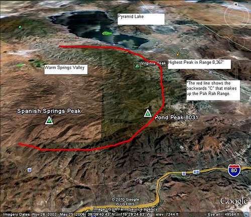 Google Earth™ image of the Pah Rah Range
The high, southeastern ridge, has three primary named summits over 8,000 feet.
These are:
Virginia Peak: 8,367 feet
Pah Rah Mountain: 8,247 feet
Pond Peak: 8,031 feet
The previously unidentified North Pond Peak 7,919' is about 2 1/2 miles north of Pond Peak, and is the third highest peak (i.e. summit rising 300' above the saddle with other summits). Pah Rah Mountain has a prominence of about 225', while the 2nd highest point, Point 8,265' has a prominence of almost exactly 200'. These are both north of Virginia Peak.
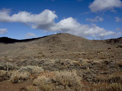 Looking up at the final stretch to the summit of Virginia Peak
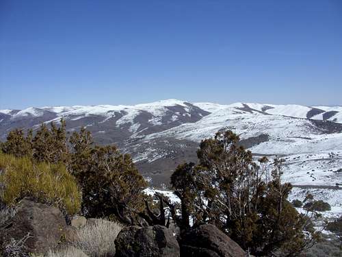 West side of Pond Peak seen from Spanish Springs Peak
All of these can be hiked in one day and are reasonable accessible. Virginia Peak has a very respectable prominence of 3,658 feet.
The northwestern part of the range includes Monte BM 7,487' and Moses Rock 7,181'. Monte BM offers one of the best views of the range, because it is right above Pyramid Lake. The route is relatively long - 13 miles round trip.
Primary access roads
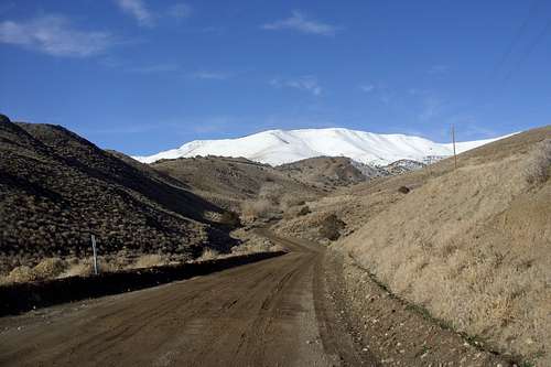
Principal hikes in the Pah Rah Range are located east Sparks and Spanish Springs and south of Pyramid Lake. Most hikes can be accessed off the Pyramid Lake Highway 445, traveling north from Sparks, Nevada. Other hikes can be accessed off Highway 447 from Wadsworth, Nevada, about 25 miles east of the 445 exit off of Interstate 80.
Calle de la Plata off of Highway 445 leads to dirt roads that reach the base of Spanish Springs Peak, the highest summit on the southeastern ridge. Further up Highway 445, Ironwood Road, just south of the Wild Horse Corral, heads through the Warm Springs Valley, and connects with roads leading to the base of Virginia Peak. Virginia Peak and Pah Rah Mountain can both be approached from the northeast side as well as the northwest. There are several dirt roads and double tracks that approach the canyons of the Pah Rah’s from the northeast, near the junction of highways 446 & 447 near Nixon, NV. In particular, there is a dirt track located one mile west of the junction to reach the mouth of Coal Creek canyon. From this point it is possible to do a loop traversing both Pah Rah Mountain and Virginia Peak back to the entrance of the canyon. This can be thick with brush during certain times of year.
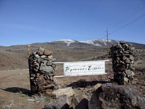 Start of the hike to Spanish Springs Peak
Pond Peak and North Pond Peak and the southeastern part of the high ridge can be reached from Highway 447 via Olinghouse Road, which goes directly towards Pond Peak and connects to Pond Peak Road. Olinghouse Road is accessed via the Pyramid Paiute Reservation, but the road isn't actually in the Reservation boundary, so this provides access. The road is well graded, but can get muddy at times. I had heard the road has a gate about 5 1/2 miles in that may be open or closed, but can be driven around. When taking a group hike up to the peak on 11/12/2011, there was no gate, and the road was open. There is about 1 mile of private land along the way to Pond Peak Road, but after the mile, public access is clearly designated up a hill to Pond Peak Road. An off-shoot of Olinghouse Road leads to prominent and colorful White Hill 5,800' and the White Horse Canyon.
 Pond Peak from the east - Christmas Day 2010
There is also access to Pond Peak from the west, a little further down the road from access to Virginia Peak via Wilcox Ranch Road. This is also a way to access North Pond Peak. Due to private land restrictions along this road, automobiles will have to drive at least up to 7,000' to legally access these mountains. This requires a good 4WD because the last two miles are pretty rough road.
Monte BM and Moses Rock are accessed from Mullen Pass off the 445 road close to Pyramid Lake. The road is at 39.8782, -119.614.
There are no major trailheads in the Pah Rah Range. There aren’t really any hiking trails. There are just dirt roads that wind through the range and enable access to primary summits. Virginia Peak is home to a Doppler Radar Station, and has a road all the way to the summit.
The closest entry to the range to the Reno/Sparks area is off Vista Blvd just north of I-80 on Salomon Ct. A dirt jeep road begins there and winds up towards Peak 5954 and a series of other hills just east of Sparks.
Red Tape
Most major hikes in the Pah Rah Range are accessible. This is mostly due to radio towers and the many dirt roads in the range. However, there are also lots of private landowners in the area. If you stick to the correct roads, there shouldn’t be a problem. If you get lost, odds are you will be greeted with a "No Trespassing" sign. So, be mindful that many roads are private, and be aware of your surroundings.
If approaching Virginia Peak or Pah Rah Mountain from the northeast, you can check camping and/or hiking restrictions with the Pyramid Lake Ranger Station at (775-476-1155).
External Links
Pah Rah Range – Wikipedia Page
Pyramid Paiute Reservation
spence - Mar 16, 2010 4:02 pm - Voted 10/10
Pah Rah accessPond Peak is not accessible via Olinghouse Road. The road is gated and marked private property approximately 4.5 miles from Highway 447.
hgrapid - Mar 16, 2010 4:50 pm - Hasn't voted
Re: Pah Rah accessThen how is Pond Peak accessed? Can you park near the gate, and find an alternate route? That shouldn't be too long a hike? Or do you need to go to Wilcox Canyon road from the west?
spence - Mar 16, 2010 5:01 pm - Voted 10/10
Re: Pah Rah accessI've never been to Pond Peak, but I have been to the closed gate on Olinghouse Rd. It looks like it can be accessed from Wilcox Canyon on the west side of the range.
hgrapid - Nov 13, 2011 3:33 pm - Hasn't voted
Re: Pah Rah accessWe accessed Pond Peak via Olinghouse Road 11/12/2011. No locked gate. There was private land, but they noted that you had to drive 1 mile through this land, and then there was a sign for public access.
rstolting - Mar 20, 2013 12:30 pm - Voted 10/10
Re: Pah Rah accessThe gate has been reopened and there is now access to Pond Peak. However there is no stopping in Olignhouse and there are private property signs on both sides of the road through the ghost town. There has always been access to Pond Peak from Palomino Valley. I don't know the name of the road but there are a few ranches on the way up to the peak.
hgrapid - Mar 16, 2010 5:23 pm - Hasn't voted
Any suggestions for Coal Creek Drainage?Is the Coal Creek Drainage a good way to access these peaks from the northeast side? Should I add this as a way to access the Pah Rah's?
spence - Mar 16, 2010 5:53 pm - Voted 10/10
Re: Any suggestions for Coal Creek Drainage?There are several dirt roads and double tracks that approach the canyons of the Pah Rah’s from near the junction of highways 446 & 447 near Nixon, NV. I used the dirt track located 1 miles west of the junction to reach the mouth of Coal Creek canyon. From this point it is possible to do a loop traversing both Pah Rah Mtn and Virginia Peak back to the entrance of the canyon. It is best to stick to the ridges and stay out of the brush choked canyon.
hgrapid - Mar 20, 2013 4:09 pm - Hasn't voted
Re: Any suggestions for Coal Creek Drainage?Thanks Spence, but isn't that on tribal lands? So you need to consult the tribe in the office in Nixon?
serrulate - Apr 25, 2013 1:18 pm - Hasn't voted
Pah Rah Traverse?Anyone know of options for a traverse across the range? i would love to link the summits. Nick
hgrapid - Apr 25, 2013 2:15 pm - Hasn't voted
Re: Pah Rah Traverse?If you want to traverse the main ridge - about 12 miles or so. Then start at Olinghouse and head up to Pond Peak. Then head north to Virginia Peak and then Pah Rah Mountain. That is probably about 28 miles round trip. Point to Point is possible. Just go from Olinghouse and finish down at 446. Remember this is BIA land, but you can certainly get picked up there, on the road to Nixon. Alternatively do a 28 mile or so horseshoe, start at Spanish Springs Peak trailhead. Then around to Pond Peak and the main ridge. But return heading east towards Moses Rock and back to 445.