
|
|
Mountain/Rock |
|---|---|
|
|
39.65222°N / 119.46345°W |
|
|
Washoe |
|
|
Hiking |
|
|
Spring, Fall |
|
|
8031 ft / 2448 m |
|
|
Overview
Pond Peak is a prominent summit in the Pah Rah Range, a mountain range that stretches from Sparks, Nevada north to Pyramid Lake. Although not the highest peak in the range, Pond Peak has a prominence of approximately 900’, and is a prominent feature if heading west back to Reno on I-80 towards Fernley. The mountain can be seen from parts of Reno, and can be easily accessed from the east, with a longer approach from the west side.Pond Peak is named for a large pond just north of the summit. The mountain is hiked on occasion, but it is often ignored by residents of Northern Nevada who prefer hiking, or skiing, in the nearby Sierra Nevada Range.
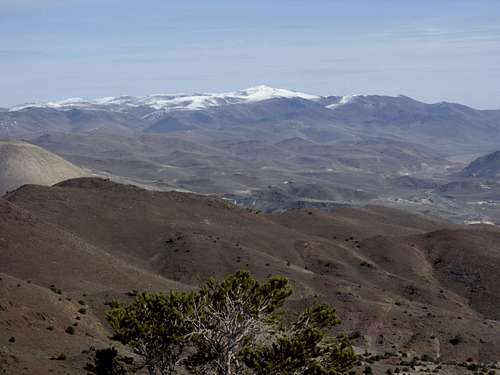
The views from the summit are excellent, with the Sierra Nevada Range to the west and many desert mountain ranges in Nevada in view in all other directions. Pyramid Lake is not visible from the summit.
Pond Peak can technically be hiked all year round, but access is more difficult in wintertime. Snow is usually on the mountain between December and February and the access road gets quite muddy from the east, and can be muddy from the west as well. The best time to hike is probably during the fall from October through early December. Springtime is also a good time to hike, just don’t hike after a rain or snowstorm due to the muddy roads. Rattlesnakes may be present on the rocky areas during warm weather months and the heat during summer can be unbearable.
Pond Peak seen from the Peak 5987 above Hidden Valley east of Reno
Getting There
The primary route to the summit is from the east side approach. Take I-80 East to exit 43, to the Wadsworth exit (427) heading northeast. Drive slow, as you are now in the Pyramid Lake Paiute Reservation. Follow signs to 447, and take it north for about two miles. On the left is Olinghouse Road. Follow this well graded dirt road for about 5 ½ miles. At this point, you will see a sign for private land. Supposedly there is a locked gate at this point, but we did not see the gate when we were there on 11/12/2011. The private land continues for about 1 mile, and then there is a sign for public access. The private land continues to the north at a big mining operation. You have to drive up to the top of a small hill to reach public land, which can be tricky for small cars, or 2WD without front-wheel drive. There is a small parking area on the left side of the road at about 5870’. 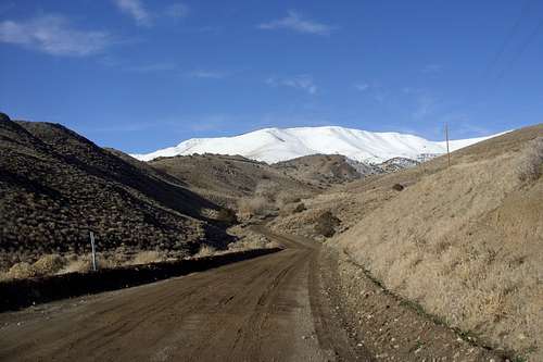
Pond Peak seen on Olinghouse Road - Christmas Day 2010
The mountain can be approached from the west side as well, via Wilcox Ranch Road. From Reno take I-80 east to exit 18 (Pyramid Highway – Highway 445). Follow Pyramid Peak north through Spanish Springs, and continue as the road becomes two-lanes. It is 18 miles north of I-80 to the turn off. The turn off is just before the Wild Horse Corral. At the turnoff, follow Ironwood Road, a partially paved road that is covered in dirt. Follow Ironwood Road for 4.8 miles to a T junction with Amy Road. Take a right on Amy Road and follow it for about 0.4 miles where the road curves to the left and turns into Wilcox Ranch Road. Follow Wilcox Ranch Road for about 8 miles. The road starts to get rough after you pass a house with a pond on the right. Signs urge automobiles to continue past private lands, which leads to a starting point at a jeep road on the right about 2.6 miles past the house with the pond. This road is at 39.66893, -119.47429 at 7,198'.
East Approach Route – Olinghouse
From the parking area, head up the first hill for just over 1/4 mile, and then leave the road and head right up the ridge. This is the most straightforward way up to the summit. This is the “East Ridge” of the mountain. It is less than 2 miles to the summit once leaving the road, and although there is no trail, it is very straightforward. There are opportunities to summit from offshoots further up the road, but the east ridge route is probably the best way. On the way down, you can take the road back. The road heads west for about 1 ½ miles before turning back around and heading east towards Olinghouse. It is 5 miles back to the parking area from the summit this way, making for a nice 7 ¼ miles round trip hike via a loop, with an elevation gain to the summit of about 2165’.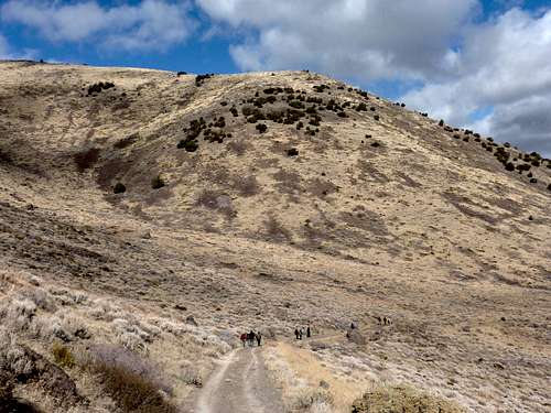
Heading back down the road towards Olinghouse
West Approach Route – Wilcox Ranch Road
You could drive even further up if you want to, but the directions are assuming you park at the jeep road at 7,198' and continue up Pond Peak Road on foot. It is very straight forward from here to Pond Peak. Simply take Pond Peak Road for a little under 1 1/2 miles and a road on the left heads up to the summit. All told, it is just under 2 miles to the summit, gaining about 850'.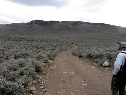
Heading up to Pond Peak from Pond Peak Road
A suggestion is to combine Pond Peak with North Pond Peak 7,919' for a 7 1/4 mile round trip hike.
Red Tape
Pond Peak is mostly on public lands managed by the Bureau of Land Management. The summit has electrical equipment, but is open to the public. Please drive slow through the Pyramid Paiute Reservation, which is crossed on the way to the mountain. Do not park on the private land on Olinghouse Road. Drive through it to get to public lands. There are signs saying you can drive through to access public lands.Watch for signs if approaching from the west. Don’t be deterred at any point. You can legally go all the way up Wilcox Canyon Road which turns into Pond Peak Road. Some side roads are off limits.