
|
|
Route |
|---|---|
|
|
37.14300°N / 118.61°W |
|
|
Scrambling |
|
|
Spring, Summer, Fall |
|
|
Most of a day |
|
|
Overview
If you don’t want to suffer up the southwest chute and don’t have the ability (or the conditions aren’t in) for one of the classic north facing couloirs, then this class 3 route for you. It is relatively easy, fun, and lands you right at the summit. Plus it’s a very reasonable day hike from South Lake unlike the southwest chute. The north ridge also makes an excellent descent route for anyone climbing the couloirs and can be used to do a nice peak bagging loop hike (described below) out of South Lake.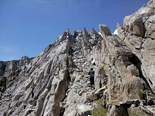
Tommey starts up one of the east side ramps to a keyhole (Aug 13)
Getting There
Follow the Bishop Pass trail to the first junction to Treasure Lakes (about a mile). After about another mile (dropping down, crossing Treasure Creek, and climbing back up), you will find granite slabs immediately to the right of the trail starting at about 10,300’. Climb up the slabs to the ridge and then slowly contour south to the creek in the next valley. Your objective is to aim for Ski Mountaineers Peak , the high point of Thompson Ridge. You may climb this peak and then traverse down or at a point several hundred feet below the summit, aim for the obvious notch in a SE running sub-ridge. An easy traverse taking less than 10 minutes gets you to the saddle between Mt Thompson and Ski Mountaineers. You can also approach this saddle more directly from the east over a fairly brutal moraine or from the west after a disagreeable hike up from Sabrina Lake. If descending from Mt Thompson via this ridge after climbing the couloirs (all located east of the ridge), it is worth the 10 minutes to traverse back to Ski Mountaineers east slope for a pleasant descent on mostly sand versus the previously mentioned acres of moraine talus that lie directly below the saddle.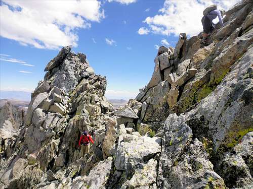
Joan used a crack to cross the ridge while Carol climbed higher to drop to the west side. (Aug 13)
Route Description
For a scramble that has been described as tricky, the route itself is fairly quick and short (>1/4 mile and about 400’). The key is to stay on the left side of the ridge except for a brief foray over to the right to bypass the crux. Easy ramps provide access along the ridge with somewhat helpful ducks along the way. At the top of the final ramp before the crux, the lack of any access on the east side makes the decision to cross the ridge straight forward. This can be done in a number of places just before and just after this last ramp. On the other side, descending to a chute that drops to the west and reclimbing it over to the top of the ridge once more puts you on the east side. The final steep ramp on the east side is the true reason for the class 3 designation. At the top of the ramp, the summit tower is immediately in front of you. Ignore all other summit towers unless that’s your kick. Descend the same way or follow the loop described next. (You can also descend the SW chute and climb Pt Powell but that would require a car shuttle)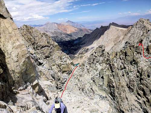
Approximate route (one possibility) over the ridge to bypass the crux on Mt Thompson's north ridge. (Aug 13)
The Loop
Not sure this is true but I’m giving Rick Kent the credit for pioneering this loop (I’ve seen no other records supporting an earlier claim). The loop can be done in either direction and can include more or less peaks depending on the desire. Best time to do the loop is probably earlier in the season when some of the talus fields and moraines are covered by snow. The description of the loop provided here is in the counterclockwise direction. Start by climbing Ski Mountaineers and then Mt Thompson by the approach and route described above. Cross Mt Thompson’s huge plateau to the east end and find the SE class 3/4 chute. This is the chute directly adjacent (south) of the chute that accesses the class 5 ridgeline directly to Mt Gilbert. Down climb the chute avoiding two waterfall pitches by moving to the left to easier granite ledges. Near the bottom, move back into the chute and descend a talus fan for hundreds of feet aiming for and crossing over the basin between Mt Thompson and Mt Gilbert. There is only one easy approach on this side of Gilbert and it’s the obvious class 1/2 chute in front of you. Climb this and follow the ridgeline to the summit. From Gilbert, traverse over to Treasure Col and climb to the top of Mt Johnson via the NW ridge. From Mt Johnson, you can either descend to the moraine mess below on the east side and talus hop (staying higher on the east side is easier) back to the Treasure Lakes trail or traverse the ridge to Trapazoid Peak. From Trapazoid Peak, you can 1) descend either to Bishop Pass or Treasure Lakes trails, 2) traverse over to Hurd Peak before descending to either trail, or follow the technical ridge over to Mt Goode before descending to the Bishop Pass trail.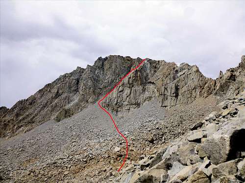
Mt Thompson's Class 3/4 SE chute with lots of loose material and acres of talus (Aug 13)
Essential Equipment
Crampons and ice ax required if climbing early in the season. No permit required if day hiking this peak.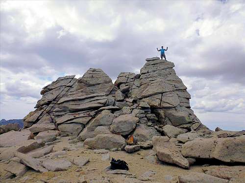
Mt Thompson's summit tower at the exit from the North Ridge route (Aug 13)
External Links
My pictures and story (see 300 series pictures)Rick Kent's photos of the loop