
|
|
Route |
|---|---|
|
|
40.48822°N / 109.23534°W |
|
|
Hiking, Scrambling |
|
|
Spring, Summer, Fall |
|
|
Half a day |
|
|
Class 2 |
|
|
Overview

This route leads to one of the great summit views in the area. It's a steep, off-trail route that leads through juniper and pine wooded areas. Along the upper areas of the route there are great views of the Uinta Mountains off in the distance to the northwest and down into the bottom of the Green River Canyon through the center of Split Mountain. The elevation gain over the course of the two mile route is 2300 feet. There are cryptobiotic soil crusts throughout the area. Please avoid them as much as possible. "So how do I recognize cryptobiotic soil crusts", you ask? Well, take a look at photo to the left. That is "crypto" soil. If you look down and that's what you see around your feet, back out of the area (and pay more attention). Damaging it will promote erosion and it takes MANY years to reestablish itself.
Getting There

The route finding starts before you get to the trailhead. The least complicated way to get there starts by heading east on 500 North/Diamond Mountain Road in Vernal, Utah. As you begin to climb out of the valley, you will pass the entrance to the landfill on the left. From this point, continue east for five miles until you reach a paved but poor quality road intersecting from the right. Turn right here and continue for a little under a mile until you reach the intersection with Brush Creek Road. Turn right again and continue south until you reach the intersection with Island Park Road, a dirt road heading to the east. Turn left here and and continue down this road for approximately 8 1/4 miles until you reach a dirt track veering off to the right. This intersection is located at 40°30.524'N 109°14.200'W. You will need a high clearance vehicle to make it down this track due to erosion and occasional rutting. This track continues 3/4 of a mile to a small parking area. All of the dirt roads may be impassable in the winter and in wet conditions.
Route Description
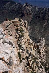
A map and compass are very useful on this off-trail route. Leave the parking area to the left and scramble over two rock spines. At the bottom of the wash after the second spine, bear right to avoid another deep gully. Pick one of the ridges between the washes that lead you directly up the face of the mountain and follow it. This is probably the steepest section but the views along the way are great. Once you reach the crest, follow it to the right until you reach the summit. On the map I've attached to this route description, I show the summit as a red dot, however my GPS indicated the location marked with the blue dot as the highest point.
Essential Gear
Sturdy boots are recommended. This is a steep and rugged route with the potential for injuring an ankle. This is an off-trail route and a map and compass are strongly recommended. There is no water along this desert route, nor is there any near the trailhead. Bring plenty along with you.External Links
Dinosaur National MonumentWeather Forecast
