From the Rawah TH to the Blue Lake TH was a shade under 24 miles
Looking back on the relative ease of doing this trip closer to home vs. the difficulties and cost of a Wind River trip, maybe we got what we paid for, but the die was cast. It was a plan that seemed to make a lot of sense at the time. Instead of spending a day getting to and another day getting back from our usual destinations in the Wind River Range, we’d drive a mear two hours from home to reach our starting point. No motels, no filling the gas tank multiple times and no long approach drives over little used backcountry roads. Definitely made a lot of sense. The Rawah Wilderness in the southern portion of the Medicine Bow Mountains of Northern Colorado was the 2010 destination for our annual weeklong backpacking/fishing/climbing expedition. Our plan was to traverse the wilderness from north to south, climb some peaks including North Rawah and sample the fishing possiblities in between.Multiple issues arose which caused us to change our starting point a couple times as well as our starting date. Because we were locked into the third week of August, my son Chris made a decision to leave us mid-week to prepare for the start of classes at Colorado State University the following Monday. Personally, I was OK with late start date thinking fewer mosquitoes would be nice for a change and that the crowds of mid-summer might be gone. I was less than thrilled about Chris leaving us, but it was his call.After all that, our plan finally set. The three of us, (Chris, Mark and myself, along with Chris’ dog Chewy) would set out from the Rawah TH on August 14th, Chris would head back out on the 18th and Mark and I would emerge from the wilderness at the Blue Lake TH on the 21st.
Rawah TH to the Blue Lake TH ~ August 14th - August 21st, 2010
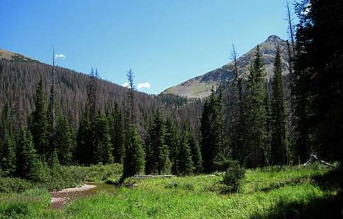
Rawah Wilderness Boundry
First night's shitty campsite
Lost Lake sign-6 miles in
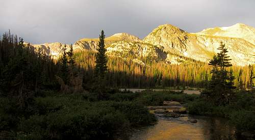
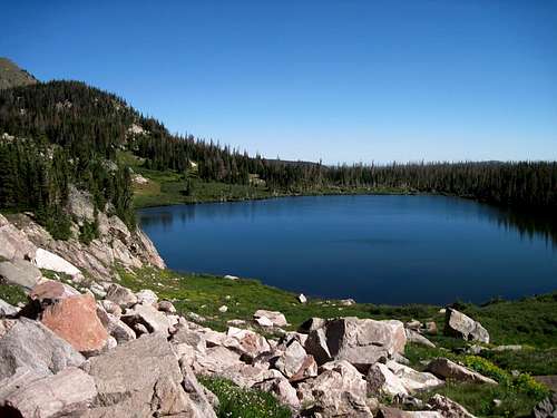
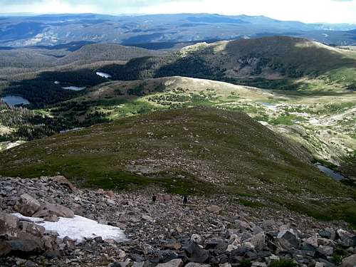
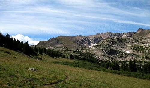
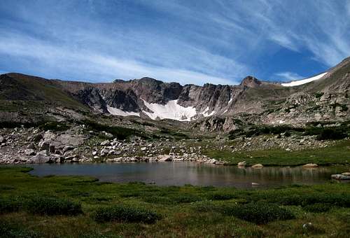
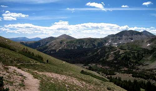
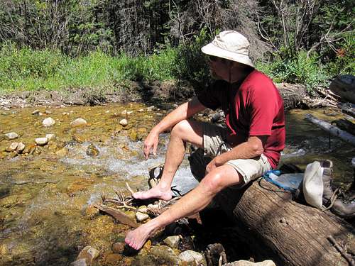
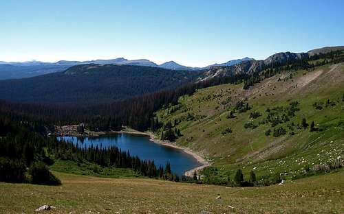
Day 1-Saturday, August 14thChris, his dog Chewy and I set out from my house at 7:20, arrived at the Rawah TH at 9:30 after grabbing breakfast on the run and picking up Mark. The small parking lot was all ready filled, but we squeezed in and were on the trail by 10. Saw only a few folks on the trail that day which we took as a good sign.Settled on a campsite around 3 PM that looked workable and was in compliance with the 200 ft rules. It was a pretty shitty little spot in a maze of deadfall, but we made it work.Figured we had traveled 5.1 miles and gained 1,500 ft. The weather had been near perfect though it did become increasingly cloudy as the day went on. But, no rain fell nor thunder was heard, so it was all good. Dinner filled our shrunken stomaches and after a nip or two we turned in. Mark’s need to answer the call in the middle of the night nearly got him lost in the timber maze. Couldn’t have been a pretty sight. Sunday, August 15th Dawned cloudless and a chilly 39 degrees F. Got packed up and on the trail by 9:45. Ran into a few more people on the trail this day before we reached our destination at Rawah Lake #1. We took our packs off near the south end of #1 to search for a suitable campsite for our three day base camp. Heading up the Little Rainbow drainage we split up, using the two-ways to communicate. I ran into a couple of female backpackers coming down the trail from the McIntyre Lakes. Had no way of knowing when I radioed back to Mark and Chris, telling them what I’d seen, including some detail on the female backpackers, that Chris was standing in front of them with his radio turned up all the way. I still didn’t know it when I came bebopping down the trail and ran into Chris, who was still speaking with them. Chris clued me in afterward. Whoooops!We ended up choosing a spot close to the north end of #1. Got camp set, had a hot lunch and then did our own thing. Chris and Chewy took a nap, Mark read (fell asleep) in his chair and me being the ADD type, went fishing. Since the brookies in the lake were quite small and would only take a high floating fly, I moved to the outlet stream and found the fish a little bigger and less picky.The third week in August brings fewer people into the Rawahs, as I had hoped. The main reason that I’d rarely ventured into this wilderness over the years, was its reputation as a crowded place. On this sunny August afternoon we saw only four people. Not exactly crowded.The weather held and we enjoyed a pleasant afternoon and evening. An excellent meal of Beef Stroganoff and pita bread put us back on track. Chewy seemed to be handling the altitude well and drinking lots of water, which was a concern during last year’s trip into the Winds. Chris brought some doggy re-hydration pills that turned plain water into a broth that Chewy seemed to like.
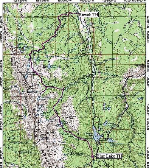
North Rawah Peak in center-the first time we laid eyes on it. From just below Rawah Lake #1, August 15th, 2010
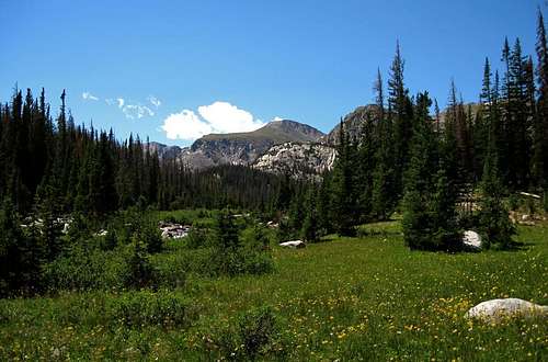
Rawah Lake #1 in late afternoon
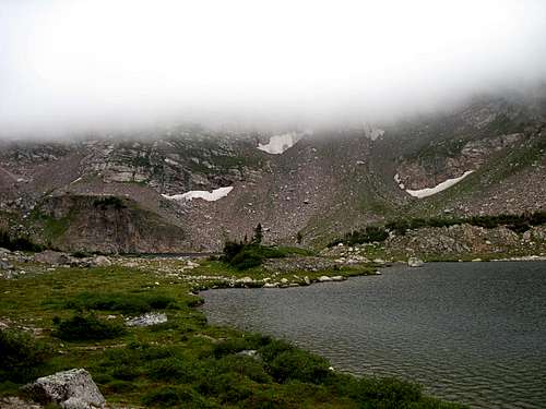
Monday, August 16th I rolled out of the tent at 6:40, to mild temperatures and cloudy skies. Temp was 51 F. Not long after I awoke the wind kicked up, blowing fiercely at times and the temperature started dropping. After putting on some more clothes, I took a bunch of pictures of the lake near the outlet stream.
First rays of sunlight on North Rawah Peak
Another sunrise shot of the lakes outlet taken while the rest of the gang was still asleep
Gathering clouds to the west
Camp Hail!
Primal warmth
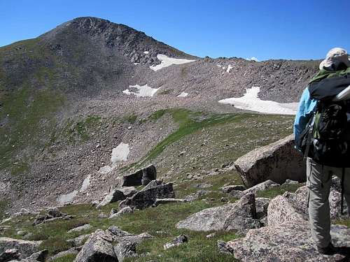
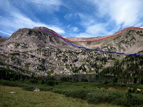
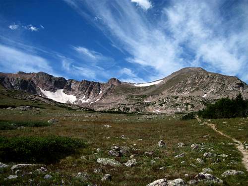
Got some coffee going and tied down everything that wasn’t all ready. Wind showed no signs of letting up with clouds looking darker to the west. I climbed a little knoll next to camp and managed to catch the NOAA forecast for southern Wyoming on my radio. Didn’t sound too bad but there was a 30 to 40% chance of showers in the PM. Started spitting rain a few minutes later so I set up our tarp just in case. Once I got the tarp up skies started clearing and the wind quit. Oh well, I thought, maybe we’ll need it later.I decided to try some fishing on the creek below since it was after 9 and nobody else was up yet. Fish must not have been up yet either as I caught nada! Chris finally got up followed shortly by Mark. Worsening intestinal problems had caused Mark to make three trips into the night. We were concerned enough to tell Mark that we could bail-out at any time and that the call was his to make. With Chris planning on leaving us on Wednesday and taking my car, our remaining options would be few. Given Mark’s condition, Chris and I figured that climbing North Rawah Peak on Tuesday would be out of the question. We spent the rest of the morning doing a little of this and that. Mark and I fished the creek, catching some bigger (8”) brookies. I managed to land a monster (11”) greenback cutthroat. The weather seemed to be following the NOAA forecast with clouds thickening to the west. A trip to Little Rainbow Lake seemed like a good idea to me, in spite of the theatening skies, to check out possible approaches to North Rawah Pk just in case we ended up going in the morning. Mark and Chris were content with staying in camp.I hiked to the McIntyre Lake Trail, taking it west, then followed a less traveled path to Little Rainbow Lake.After making the south end of the lake and spotting what I thought was the best route to get us above timberline, an intense thunderstorm hit. Was on the radio with Mark when the shit hit the fan. Big raindrops began hitting me as I headed down. Before I got too far the weather got crazy. I frantically dug into my pack for raingear as hail pelted my back.By the time I got my gear on, the hail was insane, and I was lovin’ it! Love being able to deal with a little adversity as long as I’ve got the right equipment. Walked back to camp following the whitened path covered by 2 to 3 inches of hail. Not surprisingly, Chris, Chewy and Mark were all snug in their tents when I arrived in camp and they didn’t sound too thrilled about coming outside. Since my gear was all wet, I opted to do some clean-up work in camp and otherwise hangout under the tarp, once I removed the pile of hail that had accumulated on top of it. Tried to keep the ground underneath the tarp dry but it was a losing battle. Chris came out to help get camp back in order and after it was done, we retired to the relative comfort of the tarp. As it turned out, it was a great time for a little rum, whiskey and a cigar.The rain finally stopped and with skies clearing, our normal camp life resumed. Had everybody's favorite, Pasta Primavera for dinner and life was good again. Once Chris coaxed the fire to life, it even got a little better as our chilled bones got a chance to warm.Tuesday, August 17th When we got up, neither Chris nor I figured we’d be doing any climbing based on what Mark had told us the morning before. We sat around drinking coffee, not being in any particular hurry to do anything when Mark announced that he was ready to climb. Long story short, we hit the trail at 9:30, with our sights set on North Rawah Peak. The weather looked perfect, not a cloud in the sky as we set out, following the route I had followed the day before to Little Rainbow Lake. We climbed quickly from the south end of the lake at 10,838 ft, to a broad, gently sloped bench at 11,600 ft.After taking a short break we headed south, aiming for the rock tipped ridge that lay between us and the peak.
Little Rainbow Lake at the start of the climb, looking north
The broad bench above Little Rainbow at 11,600 ft
Mark and Chris looking for a passage through the ridge
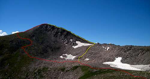
Unfortunately, I led us a little too far to the east so that when we peered over the ridge we found a steep drop-off instead of what we expected. After drifting west, we cleared the ridge, losing altitude to reach a large, flat area below a saddle that was between our peak and it’s northern neighbor at 11,800 ft.Once across the flats, we made our way up the steep north slope to the eastern aspect of the peak at 12,100 ft.
Our route up the north slope in red, alternative route we considered in yellow
Taking in the view-North Rawah Peak, August 17th, 2010~Photo by Mark M
Me strolling up the homestretch just below the summit~Photo by Mark M
From there it was a relatively short scramble to the summit. Chris, with Chewy in tow, took a more direct, steeper course up the rock pile that led to the summit while Mark and I opted for a slightly less steep route about 75 yards south.Numerous clouds hung over the range though none looked particularly threatening to Mark and I. Chris had a different take on the situation, thinking we should head down immediately after summiting. He has a great fear of lightning which is not a bad thing, but sometimes it consumes his every thought. We stayed ten minutes on the summit and dealt with nothing but high winds.
View from the summit looking ENE over the Laramie River Valley toward Sand Creek Pass
Chris and Mark descending to the eastern shoulder of North Rawah Peak
Red=Ascent Route, Blue=Descent Route
Descent route above Lake #3
We made a decision to take what looked to be an easier, more direct route down the mountain via the cirque above Rawah Lake #3. It was a good decision that got us back to camp by 3 PM. Turned in early not long after dinner. Wind blew hard during the night. I was a little sad knowing that Chris would leave us in the morning. He planned on hitting the trail by 8 AM so he set his alarm for 7.Wednesday, August 18th Got up with the alarm had some coffee and started packing. I made a decision to let Chris take our tent, not wanting to add all that weight to my pack. Chris and Mark tried to talk me into keeping it, but I wanted no part of it, preferring to rely instead on our plastic ground cloth and the tarp. It had been a long while since I’d gone so minimalist, but it seemed like the best way to go.
Chris and Chewy hit the trail back to our starting point and home
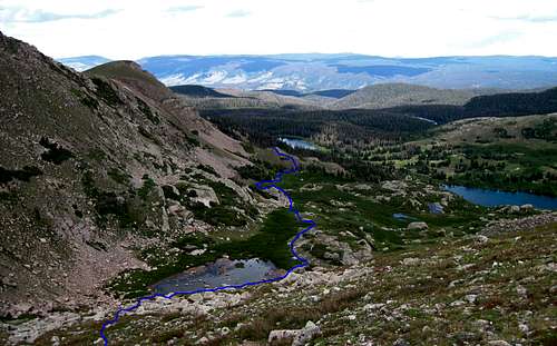
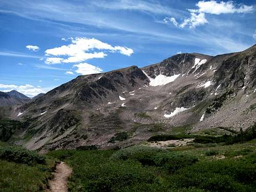
And so it went. Chris left at 9 with Chewy at his side. He planned to hike all the way back to the TH then drive my vehicle back to Fort Collins. For Mark and I, this was in a sense, our point of no return. Our way out lay 14 miles south, at the Blue Lake TH, where we hoped our wives would be waiting us on Saturday, the 21st.About 50 minutes after Chris left, Mark and I hit the trail with our goal being the Twin Crater Lakes area on the south side of Grassy Pass, about four and a half miles south.The first part of the climb up Grassy Pass was the steepest but it wasn’t too bad as far as passes go, a mear 500 ft elevation gain to the top. Took many pictures of the magnificent views along the way. The weather was perfect!
The approach to Grassy Pass from the north
Tarn along the trail just east of Rawah Lake #4 and the immpresive scenery above it
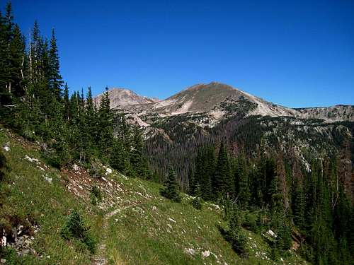
Looking back toward North Rawah Peak from the trail just below Grassy Pass
We saw no one on the trail until we started down the south side of the pass. First group we encountered consisted of a volunteer leading 4 llamas and 2 blind hikers with guides. A couple of women on horseback and a lone female hiker cutting switchbacks rounded out the crowd.
South Rawah Peak from the south side of Grassy Pass. August 18th, 2010
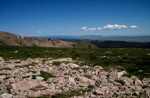
Looking south from Grassy Pass with the Mummy Range left, Cameron Peak, left of center, Dodad right of center and perhaps Lewis right of Dodad,August, 18th, 2010.
Twin Crater Lakes Tr
Riding high-Before the Rain
Low Rider look
We made our way down into the forest until we reached the Twin Crater Lakes Trail junction. Stashed our packs there and went looking for a suitable campsite. Finding none near the jct, we hiked up the Twin Crater trail about a half mile where we found a nice, well used spot that bordered a meadow. After hiking down and back to retrieve our packs, I spent some quality time sitting in that meadow, basking in the afternoon sun, soaking my hot feet in the cool waters of the small stream that ran through the middle of the meadow. Mark was finishing his camp set-up when I got back to camp and started working on mine. Took me quite a while to get the tarp set up but I finally got it done shortly before it was time for dinner. Not long after dinner, the weather started changing. Skies darkened and soon the rain came. Not thunderstorms but a more general rain that varied from a drizzle to a wind driven gale.Before Mark got into his tent, he just had to say, “you should have kept the tent” one more time. I had a bad feeling that he might be right. But, as it were, I had to persevere and make the best of it. So that’s what I did. My space under the tarp did not allow much room for error so I found myself constantly tightening the tie downs and trenching the perimeter. Just before dark, the storm took a turn. The rain and wind intensified, with the wind coming from the south. I had to make some serious adjustments as my down bag was getting wet. Mark yelled out something that I couldn’t make out, but I guessed it was about coming into his tent. I made adjustments, dropping the edge of the tarp on the south side from about two feet high to 10 inches above the ground and that seemed to do the trick.Don’t think I really fell asleep till the wee hours of the morning which is strange considering that I turned in before 8 PM. I remember looking at the time at one point in this long night and it was 1:34 AM. A combination of things kept me awake-worrying about the rain getting my sleeping bag wet and listening to the sounds of the night. It had been many years since I slept without the “insulation” of a tent and laying there under that tarp I learned that, in spite of my advancing years, my hearing is still good enough to hear a titmouse fart and I heard plenty of em’. Every little sound jolted me awake. Bad night, to say the least.Thursday, August 19th I was glad to get out from under the tarp after a tough night. Fortunately, I’d managed to stay dry.Once I got my muscles moving and had a little coffee my outlook improved considerably. Unfortunately, the weather didn’t. Rain continued off and on with periods of wind driven fog in between. Mark didn’t have a good night either, suffering with a migraine headache.So, in the spirit of trying to keep a stiff upper lip, we marched off after breakfast, bound for the Twin Crater Lakes to check out the fishing. A mile or so hike with a stiff climb at the end, brought us to the first lake. The larger, upper lake lay right behind the first, only a few feet higher. In better weather it must be a spectacular place, but with the clouds only slightly above our heads, it’s beauty was severely muted..
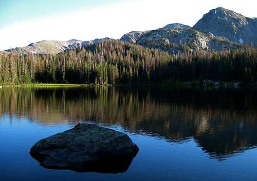
Lower Twin Crater Lake with Upper barely visible behind it
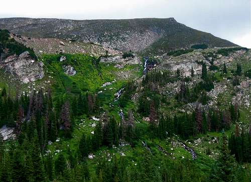
Stll, we pressed on, hoping against hope that the fishing might be decent in spite of the weather. It wasn’t. Mark saw one fish raise, I saw no sign and had no hits.We stayed there for an hour before heading back down. Along the way we stopped to admire and photograph a beautiful series of cascades flowing down the slope below Rockhole Lake. Couldn’t escape the thought of SPer Nelson and Jude’s ordeal at that same lake some years back. It’s a long way to be from a road if you need medical assistance. Fortunately for us, we needed none.
Outlet cascades flowing from Rockhole Lake
Made it back to camp around 1:30ish and had a nice hot ramen lunch, finishing just before the next batch of rain hit. Mark fled to his tent, and back to “The Count of Monte Cristo” while I crawled back under my tarp, to write this in my journal. To break the monotony, I would write for awhile then checked the time and temperature then write some more. At 3:15 the temp was 51 F. Watched a cow moose and calf move across the open area a short distance below our camp.3:41 still raining, still under the tarp- temp 50 F.4:11 still raining, temp 49 F.“It’s times like this that try men’s souls”, I thought. And times like this that make me wonder, “What the hell am I doing here??”Finally, the rain tapered off and I ventured out from under the tarp again. With the falling temps my feet started getting cold so I put on my boots and took a walk in the forest with the thought that I’d gather some firewood. “Just what the doctor ordered”, I thought, “A nice, warm fire would definitely cheer things up around here.” Wood was hard to come by in this well used campsite, doubly hard when everything is wet. I scounged what I could, and was feeling quite proud of the small load I hauled back to camp when the rain started in again.It’s now 5:14, temp 46 F and raining coming down hard. Mark is nestled in his tent, still reading I presume. I’m not liking the way things are going and I’m missing Chris a lot. With him and Chewy gone, the dynamics of the trip are completely changed and I’m struggling with it.Mark finally popped out of his tent, apologizing for not being very good company, citing his continuing migraine. Thankfully, his headache was beginning to fade. Had Beef Teriyaki with rice for dinner. Sat on a log under a thick fir tree and enjoyed a bit of libations and a cigar before turning in. Still raining.I set the tarp low to minimize moisture invasions and pulled my head into the sleeping bag to shut out the outside world as much as I could and it worked! I slept a good sleep!Friday, August 20th I was relieved to awaken and see clear blue skies as I peered out from under the tarp.
After 30 hours of rain, low clouds and fog, I was real glad to see the sun!
Mark was all ready up and at em’ when I crawled out of my bag. After some coffee and breakfast, we spread out what needed to be dried in the sun and started packing. Got on the trail a little late (10:30ish), but we didn’t have far to go and, for the most part, it was all downhill. A series of switchbacks got us down the steep sections after which we hit the West Branch Trail. Took a slight detour down the trail to take a lunch break near the West Branch Bridge.
Zoning out~Photo by Mark M
Chugged back up the trail to its junction with the Blue Lake Trail where we dropped our packs and went looking for a campsite. Mark found a nice one a short way off the Blue Lake Trail. Once camp was set, Mark plunked himself down in a sunny spot and jumped back into “The Count”. I grabbed some Kool-Aid, my piece of ensolite, my journal and found my own place in the sun, sitting on the last log bridge we’d crossed. Sat there writing this, looking at my map, sippin’ Kool-Aid, thinking it doesn’t get any better than this. But such moments are fleeting, especially in the high mountains in the latter half of August and, after about 40 minutes, the shadows were lengthening and it was time to go.Mark was still sitting in the same spot, still reading when I approached. We discussed what we needed to do and got to it. First job was to find a suitable tree to hang our food bags. Had a tough time finding a good tree. The best one we found needed some modification. Drawing on my old winter camping experiences in Pennsylvania, I threw a rock tied to a rope over branches that were in the way and pulled them down. I guess I forgot that when you do that, the branch comes flying at you at a high rate of speed and that’s exactly what happened. The first one smacked me hard in the back of my right hand, giving me a nasty little puncture wound. Didn’t seem like a big deal at the time but I would learn the next day that the impact also bruised the bone in the back of my hand, and that would turn out to be a bigger deal. After that incident, I got better at jumping out of the way and we were able to hang the food bags high. When that was done we gathered a little firewood, pumped some water and began to prepare dinner. Our food supplies were almost gone and all we had left was black beans and rice. This was our “Pot Luck” meal and was meant to include some trout, but sadly, there were none in the vacinity. Our meal was decent, but decidedly gruel-like.The good weather held and we had a pleasant evening sitting around the fire, making our packs a little lighter for the next day’s journey. We’d start our last day by climbing to Blue Lake Pass and end it at the Blue Lake TH, a distance of 7.2 miles. Not like me to plan the last day of the trip to be our hardest, but that’s how it worked out. Our plan was to be on the trail by 8:30 and to make the TH at 12:30. Suffice it to say, it was an ambitious plan.Saturday, August, 21st Alarms went off at 7 AM as planned. Packed it up and were on the trail a little later than planned at 8:50. Our climb to the pass would be 900+ feet in a little over a mile. Always like to get the big climbs done at the beginning of the day. Once over the pass, our hike would be all downhill. Sounded like a piece of cake.
Blue Lake Pass from the West Branch
View north from the Blue Lake Trail
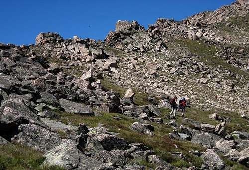
We blazed up the lower sections of the trail to the pass under cloudless skies. First half of the climb wasn’t too bad - second half was a little more in your face. In spite of the grade and downed timber on the trail, we made it to the top at 10 AM. We probably spent too much time relaxing on top - taking a half hour for photos and replenishment. At any rate, we were back on the trail, trying to move fast to meet our goal of 12:30 at the TH. Mark suggested we push it as far as we could without taking a break. We pushed on.
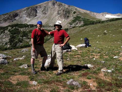
Mark and I atop Blue Lake Pass and near journeys end
Blue Lake - Looking south from Blue Lake Pass. August 21st, 2010. Longs Peak is visible at left on the far horizon, Mount Richthofen on horizon at right.
Ran into a lot more people than we’d seen previously, that were heading up to the lake and the pass. One of the hikers we’d passed said it was supposed to be 100 F in Fort Collins this day. It was starting to feel like it! I had to quit using the trekking pole with my injured right hand as it was becoming quite painful. Strapped the pole on my pack and pressed on. The pain got worse with my hand dangling at my side so I starting draping it over my Platypus tube, which made a sort of a sling and that felt alot better.The one trekking pole thing slowed my pace considerably, particularly on the steeper downhill sections. Plodding along, I tried to move as quickly as possible but I’m afraid that between the heat, lack of breaks and the effects of my hand injury, I wasn’t moving too fast. Mark gave me words of encouragement, which helped a little.At 12:10, my radio jumped to life. Couldn’t hear it very well or get a response due to still being two to three miles from the TH, but I could tell it was my Lynda and that was a good sign! We trudged onward, hoping to see the bridge ahead, which would mean a little less than two miles to go. We finally crossed the bridge and climbed a short hill that put us on the old 4WD road that would eventually lead us to the TH. As we got closer, we were able to communicate via the two-ways so we knew our wives were waiting at the TH with lots of goodies. The remainder of the trek took on that familiar “it’s never going to end” feel until we saw two beautiful women hiking up the trail towards us. What a sight (and smell) we must have been, but in spite of that they seemed as glad to see us as we were to see them. Once we reached the TH parking lot it was party time - Tailgate style. Real food washed down with real beer in the company of some real fine women! Not the same feel as the Lander Bar on a Saturday night, but I wouldn’t have traded it for anything.
wow....what an adventure; especially with the weather. I'm glad Mark got better and you were able to get up North Rawah. Funny about the female hikers and the walkie talkie. hahaha....hope nothing too crazy was said.
Thanks, Nelson. I did get some memories for sure, though some were not the kind I was looking for. Still, you never know how it's going to go, wherever you go.
Definitely looking forward to a return the the Winds next year, if it's in the cards.
Parents refers to a larger category under which an object falls. For example, theAconcagua mountain page has the 'Aconcagua Group' and the 'Seven Summits' asparents and is a parent itself to many routes, photos, and Trip Reports.


Comments
Post a Comment