
|
|
Mountain/Rock |
|---|---|
|
|
40.67623°N / 105.96678°W |
|
|
Larimer/Jackson |
|
|
Scrambling |
|
|
Summer, Fall |
|
|
12473 ft / 3802 m |
|
|
Overview

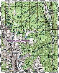
North Rawah Peak is located in the north central portion of the Rawah Wilderness in Colorado. At 12,473 ft, it is the 5th highest peak in the Medicine Bow Range and is also the highest mountain in the range, north of its taller brother, South Rawah Peak. From this peak, the crest of the range drops gradually as it winds northward into Wyoming before rising again, in the Snowy Range.
The summit marks the northern edge of a precipitous ridge that stretches from South Rawah Peak. The scenery in between is some of the most spectacular in the Wilderness and features one of the Wilderness’ larger snowfields which clings to the steep slope above Rawah Lake #4.
The peak ranks 1,021st in the state and 384th as a 12,000er according to Gerry and Jennifer Roach's 12,000er Peaks List.
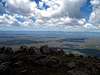
Views from the summit
Unimpeded views in all directions are the climbers reward, with South Rawah Peak being the only nearer, taller peak.North Park and the Park Range to the west, the central portions of the Medicine Bow Range and Snowy Range to the north, the Laramie River Valley and lower ridges of the Laramie Mountains to the east, the Mummys and Never Summers to the south.
 |
 |
 |
 |
 |
 |
Climbing info


This mountain is basically a Class 2 walkup. Long approaches make this mountain more interesting and less visited. The nearest trailheads, Rawah and West Branch, are over 10 and 8 miles away, respectively.
Routes
Many routes are possible to the summit from the south, east and north. For the ambitious, it appears that the North and South peaks are doable together.
Directions


This peak is accessible primarily via the West Branch Trail and the Rawah Trail.
West Branch TH from Fort Collins- Take Hwy 287 (College Ave in town) north to what's known as Ted's Place (Gas station/conveience store). Turn left onto Colo Hwy 14, heading west for approx. 51 miles to the junction with Larimer Co RD 103 (Laramie River Road). Turn right (north) onto LCR 103, following it for 6.8 miles to the TH.
Rawah TH from Fort Collins-
Same as above except drive 11.5 miles north on LCR 103 to the TH.
Red Tape
No permits or fees at this time.Long story short-No campfires above 10,800 feet/No camping within 200 feet of water or any trail! Special closure zone rules also apply in certain areas.
See Rawah Wilderness Regulations for details.