
|
|
Area/Range |
|---|---|
|
|
40.99571°N / 106.18938°W |
|
|
Hiking, Mountaineering, Trad Climbing |
|
|
Spring, Summer, Fall, Winter |
|
|
12951 ft / 3947 m |
|
|
Overview
 Locator Map
Located in north-central Colorado and southern Wyoming, the Medicine Bow Range stretches for a hundred miles from Cameron Pass in the south, to Elk Mountain in the north.
 Looking north at the southern end of the range
High elevations, peaks and lakes dominate the southern and northern reaches of the range, with lower, forested ridges being the mainstay in between. On the western fringes of the central portion of the range, the North Platte River cuts a deep, narrow, canyon over 20 miles long.The Colorado portion of the Medicine Bow is held between the Laramie River Valley on the east, and the high mountain valley or park known as North Park, on the west. In Wyoming, the range widens and is bordered by the Laramie Plains to the east and the North Platte River Valley to the west.
Using the 300+ ft of prominence rule, the range features 18 peaks over 11,000 feet and includes 9 over 12,000 feet, with 12,951 ft. Clark Peak being the highest. Climbing oportunities are concentrated in the southern and northern ends of the range.In Colorado, the range lies within Roosevelt NF and the Colorado State Forest (CSF), with a few small pieces tucked into Routt NF. Medicine Bow NF encompasses nearly all of the range in Wyoming. The crest of the range serves as the border of Larimer and Jackson Counties in Colorado.For descriptive purposes, the range can be divided into three sections:The north-south oriented, Alpine portion that is found in the south, the lower elevation timbered ridges and canyons in the middle, and the broad, high elevations of the Snowy Range in the north.
UPDATE - Wildfires in the Medicine Bow
As of December, 2020, the two large fires in the Medicine Bow Range are 100% contained. Near the southern end of the range, the Cameron Peak Fire, which started on August 13th, consumed 208,913 acres and the Mullen, In the central and northern portions of the range, burned 176,878 acres. Several Wilderness Areas have been affected - The Rawah Wilderness, where the Cameron Peak Fire started as well as the Comanche Peak Wilderness suffered fire damage. The fire also burned the northern Mummy Range in Rocky Mountain National Park. In Wyoming, the Savage Run and Platte River Wilderness were also damaged by the Mullen Fire. Ignition point-Blue Lake Trail-Rawah Wilderness
 Cameron Peak Fire-134,559 acres Mullen Fire-175,535 acres
Geology
 Cameron Peak in September
 High peaks of the Rawah Wilderness from the Laramie River Valley
 Rock Glacier Illustration, courtesy of Dr. Bruce Railsback, Univ of Georgia
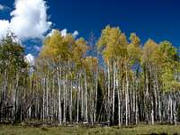 Fall colors along the Laramie River
 The Proterozoic, or Medicine Peak Quartzite that is part of the Medicine Bow Ridgeline is evident in this photo of the northern end of the ridge.
 The Laramie River in late September
The Medicine Bow Range was formed during the Laramide Orogeny, which began about 70 million years ago and lasted approximately 30 million years. Multiple faults in the area were thrust upward, creating the beginnings of the range. After a period of much volcanic activity, 25 to 40 million years ago, the range and surrounding areas were buried under a thick blanket of volcanic ash. Over the last 25 million years, the range continued to rise, reaching it’s current elevation in the last few million years. All the while, the power of erosion sculpted the canyons and valleys. Climate changes beginning 1.8 million years ago changed the engine of erosion from water to ice and the era of the glaciers began. Glaciation During the Pleistocene era, two Glacial Advances occurred in the Medicine Bow Range: the Bull Lake and the Pinedale. The Bull Lake event took place from 50,000 to 125,000 years ago, the Pinedale, 7,600 to 29,000 years ago. These were periods of extensive glaciation, with the Bull Lake glaciation being the most extensive.More recently, three smaller advances known as the: Triple Lakes, Audubon and Arapaho Peak made their mark on the range. The last of the three is commonly referred to as “The Little Ice Age”, and took place from the 14th to the mid-19th centuries. While no active glaciers are found in the Range today, numerous “permanent” snowfields exist in the southern and northern reaches. Unique Features There are two active Rock Glaciers located on the eastern slopes of South Rawah Peak.Two sets of Cold Weather Sand Dunes are located at the western foot of the range: The East Sand Dunes and the North Sand Dunes. Cold climate dunes contain sedimentary structures unique to moist, cold-climate dunes unlike the dunes of Great Sand Dunes NP. Like Great Sand Dunes NP, these dunes were formed when westerly, sand-bearing winds slowed and deposited their load on the western flanks of the range.The East Sand Dunes Natural Area contain the only undisturbed, cold-climated dunes in Colorado. The area is mostly within the boundries of the Colorado State Forest but is only accessable from the east. The North Sand Dunes, on the other hand are very accessible and open to recreational use by OHV’s and accordingly, not deemed a natural area. The North Dunes are currently managed by the BLM as The North Sand Hills SRMA
South-The Rawah Wilderness & The Colorado State Forest
 Rawah Wilderness-central section
 The ranges apex-Clark Peak, over North Michigan Reservoir, Colorado State Forest
 Southwestern portion of the range in the Colorado State Forest
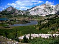
From south to north, the southern section of the range encompasses the area from Highway 14 to the northern edge of the Rawah Wilderness, a distance of 25 miles. From east to west, it ranges from the Laramie River Valley to North Park, varying from 9 to 15 miles wide. High alpine peaks, glacial cirques and pristine lakes are the rule in this southern portion of the Medicine Bow Range.
 Colorado State Forest Map
The 76,394 acre Rawah Wilderness is located on the eastern slopes of the range while the 71,000 acre Colorado State Forest lies on the western flanks.Elevations range from 8,000 to nearly 13,000 feet. No roads cross this southern part of the range. Rawah Wilderness
 Looking south at the Diamond Peaks from the Montgomery Pass area.
 Skier above Montgomery Pass with Parkview Mtn. in the background
 Kelly Lake, Colorado State Forest
 Ruins of Old Man Kelly's cabin below the namesake lake, Colorado State Forest
 Dodad Peak or as I know it, The Sphinx, Point 12,046 from Timber Lake
Was originally part of the Medicine Bow Forest Reserve, created in 1897. In 1964, with the passage of the Wilderness Act, the 27,494 Rawah Wilderness was created. The Colorado Wilderness Bill of 1980 added 48,900 acres, bringing the total to its current 76,394 acres. The Wilderness contains 25 named lakes, numerous glacial cirques and more than a dozen peaks over 11,000 feet.
 Clark Peak>Sickle Mountain October, 1979
“Rawah” is a native american word meaning “wild place”. The Colorado State Forest State Park The Colorado State Forest was officially established on December 2, 1938, with President Franklin Roosevelt's issuance of a patent to the state of Colorado for 70,980 acres. It is administered by the Colorado Division of Parks.The majority of this side of the range lies at a lower elevation than the east side. The steep western flanks of the range in the State Forest are home to three small glacial cirques. Roosevelt NF Trailheads Access to the southern and southeastern parts of the range Zimmerman Lake Blue Lake West Branch Rawah Link-McIntyre Colorado State Forest TrailheadsAccess to southwestern part of the rangeMontgomery Pass Ruby Jewel Kelly/Clear Lake Medicine Bow Notable Peaks Clark Peak - 12,951Lewis Peak (FKA Sickle Mountain) - 12,654South Rawah Peak - 12,644Snowbank Peak - 12,522North Rawah Peak - 12,473Point 12,386Cameron Peak - 12,127Dodad Peak - 12,046North Diamond - 11,852Sheep Mountain - 11,820Point 11,667Point 11,330Point 11,232 Camping options Roosevelt National ForestChambers Lake CG Tunnel CG Browns Park CGSome dispersed, primative camping options may also be available in certain areas. See RNF link for details.Stub Creek Cabin RentalColorado State ForestNorth Michigan CGBockman CGInfo on State Forest campgrounds, dispersed and backcountry camping State Forest camping info . Cabins and Yurts are available for rent within the State Forest.A KOA campground is located near the park entrance.
Central-Including the Platte River and Savage Run Wildernesses
 Platte River Wilderness view
 Northern end of Northgate Canyon, North Platte River
Forested ridges, punctuated by small and medium sized creeks, run from the northern edge of the Rawah Wilderness to Wyoming Highway 130, on the south side of the Snowy Range, a distance of some 37 miles. On the western edge of the range, the North Platte River’s Northgate Canyon provides a wild, remote river canyon. Elevations range from about 7,400 in the canyon bottom to 10,700 at the extreme southern and northern fringes of this section. Motorized recreation is the rule in all but the wilderness areas of this central portion of the range thanks to a myriad of forest roads.
 Platte River Wilderness map
 September colors on the North Platte
Platte River Wilderness Created in 1984, this area encompasses 23,492 acres along the North Platte River in Northgate Canyon. Average elevation is 7,700 feet. Most of the wilderness lies in Wyoming (22,749 acres) with a small portion in Colorado (743 acres), where North Gate Canyon begins. The canyon is popular with white-water enthusiasts and anglers.The Platte River Trail offers some hiking oportunities in the canyon. Because of the narrow canyon and high river flows, late summer is often the best time to hike the canyon. The Douglas Creek Trail follows it’s namesake creek for 9.5 miles with a trailhead at either end.
 Savage Run Wilderness Map
 Looking south over Northgate Canyon
 Platte River Road near Pike Pole CG
Savage Run Wilderness Designated in 1978, this wilderness currently contains 14,927 acres. Located just north of the Platte River Wilderness, this area is bordered by the Horse Creek Road on the east, the Platte Access Road on the south and the French Creek Road on the north. The Platte Access Rd provides access to the Savage Creek Trail via the Cottonwood Trail. Central Section TrailheadsWestDouglas Creek Pelton Creek Platte River Six Mile Gap North Gate French Creek Silver LakeSavage Run EastSheep Mtn Chimney Park Corner Mtn
 Hooked Up! Northgate Canyon
Camping OptionsEastBarber LakeLibby CreekRob RoyLake OwenBobbie ThompsonMiller LakeBoswellWestSix Mile GapPike PolePickaroonFrench CreekSilver Lake
North-The Snowy Range
 Shelf Lake
 Snowy Range Map
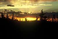
 Another Snowy Range sunset!
 North Gap outlet and Point 11,761
This portion lies mainly in the Snowy Range and is dominated by Medicine Bow Peak, Browns Peak and Elk Mountain. Medicine Bow and Brown’s peak’s seperate ridges, measuring 4.5 and 3 miles, respectively, provide a spectacular backdrop to the area’s numerous lakes and large snowfields. Though the Snowy Range is not designated as wilderness, motorized travel has been limited since the 60's. Perhaps because of the rocky nature of the trails in the upper reaches, horseback travelers are not evident.
 Medicine Bow Peak Ridge over Lewis Lake
The range ends on the south side of Interstate 80, at Elk Mountain, 30 miles north of Hwy 130.Much of the upper portions of the Snowy Range, are closed to motorized travel.Elk Mountain, the northern terminis of the range, is located on private land.
Notable PeaksMedicine Bow Peak- 12,013Browns Peak-11,722Sugarloaf-11,395Elk Mtn-11,156
 Sugarloaf and Medicine Bow Pk.
 Southern end of the Medicine Bow Peak Ridge, above Mirror Lake-Sept 2009
Point 11,761TrailheadsNorth ForkLittle LaramieDeep CreekDeep LakeCrater LakeBrooklyn LakeLewis LakeStump HollowDipper LakeVagner LakeCamping & Cabin Rental optionsBow RiverBrooklyn LakeDeep CreekLincoln ParkNash ForkNorth ForkSouth Brush CreekSugarloaf
Seasonal Access
 Wooden ski wax woes-Snowy Range
 Clark Peak (right) from the Sawmill Gulch Trail-Feb 2010
 Skier in the Snowies
SummerThe Laramie River Road usually opens sometime in May. Depending on snowpack levels, trails leading into the southern parts of the range can be snow covered until early July. Most roads in the CSF are open year-round, though access to some trailheads may be limited until early June.
The Snowy Range Road usually opens on Memorial Day Weekend. Some trailheads can be inaccessible by vehicle into early July. Trails in the higher elevations can be snow covered well into July, depending on snowpack levels. The Laramie River Rd and Snowy Range Rd are open until snow closes them in the fall, usually around October or November.
WinterDue to the winter closure of the Laramie River Road, non-motorized access is limited to the extreme southern portion of the Range via Colorado Hwy 14.
On the western side, some access is available through the CSF.
Wyoming Highway 230, which is open year round, provides a narrow corridor of access to the central parts of the range though it is primarily used by snowmobiles.Further north, Highway 130 is closed in winter and access is from the end of the closure on the east and west sides of the range. This area also is primarily used by snowmobilers.
History
Prior to the arrival of Europeans, various Native American tribes ventured into the range at certain times of the
 Snowy Range Sunset
year to hunt and gather lodge poles. From the north and east, Northern Arapaho and Cheyenne, Oglala Sioux and Eastern Shoshone all frequented the valleys adjacent to the range. From the west came the White River Utes. Meetings between the Utes and the eastern plains tribes
 Hiking the Gap Trail along South Gap Lake
were not cordial and in effect, the range served as a no-mans land between mountain and plains tribes.The name Medicine Bow conjours up images of the old west and, rightly so.
 South Gap Lake
The origin of the name comes from a merging of terms that early settlers associated with the range. The word “bow” refers to the local native’s preference for a particular variety of mountain mahogany found in the lower valleys of the range which they used to make bows of exceptional quality. The word “medicine” was associated with tribal gatherings, or powwows, that were held annually in the mountains. The tribes made their bows and held ceremonial powwows to heal the sick and rid the tribes of disease. The term “powwow” translated into “making medicine” to the settlers and over time, the two words were combined into Medicine Bow. In the early 1800’s, trappers began to penetrate the mountains and valleys of the Medicine Bow. One in particular left his name on the area. French trapper, Jacque La Ramie ventured into the valley of the river that would later bear his name to build a cabin and trap. He traveled alone to the fringes of the Medicine Bow Mountains in the Spring of 1820 and was never seen again. Rumor at the time suggested he was killed by natives, his cabin burned. A few years later, in 1834, Kit Carson spent a summer trapping near the headwaters of the Laramie River with three companions. Shortly before the group was to join up with Jim Bridger and head to the annual rendezvous on the Green River, Carson had an encounter with two huge grizzlies while hunting on the eastern slopes of the range. He managed to survive by climbing a stout aspen.The advance of the Union Pacific Railroad in 1867, across southern Wyoming brought in a new group of white men to the range-Loggers. Railroad lumber contractors operated camps in the mountains to supply railroad ties for the transcontinental railroad. The loggers, known as tie hacks, cut hundreds of thousands of lodgepole pine trees, which they hand-hewed and then floated down the Cache La Poudre and Laramie Rivers.A little piece of Tie Hack HistoryOn the eastern slopes of the central portion of the range was found a logging camp called Old Roach, which operated in the 1920's and 30's.Logging also took place on the western side of the range, though it wasn't all about railroad ties. In the Colorado State Forest logging activity peaked in the middle of the 20th century. The focal point for that activity, the Bockman Lumber Camp, grew to become Colorado's largest. See State Forest History for more detail.Most of the mining activity occurred in the northern section of the range. The town of Centennial on the eastern slopes of the Snowy Range, was a focal point for mining activity. Many mines were located high in the range, just west of Medicine Bow Peak in an area known as Gold Hill. Like a lot of mining in the west, the boom was followed by a bust, though there are still some active mines today. Water was the next resource to bring attention to the Medicine Bow. By the late 1800s river flows to the dry eastern plains of Colorado were already allocated which spurred speculators to seek new sources in nearby drainages. The Laramie River Valley on the eastern flanks of today’s Rawah Wilderness was one such source. A grand plan involving miles of ditches and a tunnel through the mountains to bring water from the Laramie to the Cache La Poudre was born. The plan didn’t live up to it’s potential when the United States Supreme Court ruled in Wyoming’s favor in 1922. Some of the ditches and the tunnel are still in use today though they don’t carry as much water as the original investors had hoped. With the publication of the world's first “western” novel, Owen Wister’s “The Virginian” in 1902, the name Medicine Bow became known world wide. Wister set his novel in the northern foothills of the range, near the town of Medicine Bow.
Wildlife
 Mule Deer along the Sand Lake Road
Moose, elk, mule deer, bighorn sheep, mountain lion, black bear, coyote, bobcat, marmot, pika, beaver and fox are currently found in the range. Fish of the Medicine BowBefore the arrival of the white man to the region, the waters of the Medicine Bow Range contained no trout. Stocking, which began in the late 1800s, introduced several species of trout, two species of char and the Montana grayling.
In recent years some of the introduced species have been removed from the lakes in the southern reaches of the range in favor of the greenback trout, which is the “native trout” of the Colorado Front Range. Along with the greenbacks, anglers in the Rawah Wilderness may find: rainbow, mackinaw (lake trout) and brook trout. In the Colorado State Forest, brook trout, cutthroat trout, brown trout and rainbow trout are present. Golden trout and grayling which were once present in Kelly Lake are gone in favor of the “non-native” native, greenback trout. The greenback has also been stocked in the CSF’s 2 other high lakes-Clear Lake and Ruby Jewel Lake.
The Laramie River contains brook trout in the upper reaches with brown trout dominating the lower stretches.
Rainbow and brown trout are the most common trout found in the North Platte River.
The small creeks in the central part of the range are primarily populated with small brook trout.
In the Snowy Range, a similar variety of introduced salmonids can be found, though brook trout seem to dominate.
Red Tape
Rawah Wilderness and Roosevelt NF
 Lost Lake outlet as the afternoon sun wanes
No backcountry permits required at this time other. Certain areas in the Wilderness have special regulations.Check Rawah Wilderness Regulations for details.Colorado State ForestA State Parks Pass is required for entry. Check CSF for a current fee schedule and Park regs. Platte River Wilderness No backcountry permits required at this time. See Platte River Wilderness for details. Savage Run Wilderness No backcountry permits required at this time. See Savage Run Wilderness for details. Medicine Bow NF No backcountry permits required at this time. Some parking lots/trailheads in the National Forest are marked as FEE Areas. Medicine Bow National Forest seems to be intent on charging day-use fees in certain areas. See Fee Areas for detail.
External Links
 The range can see a lot of snow as evidenced by this snow covered outhouse
 Spider Web in the right light-Northgate Canyon
 Sister Cyndi getting out of the rain-Shelf Lake, Snowy Range
Colorado State Forest Medicine Bow National Forest
Weather
Southern Area-Rawah/CSF Central Area Northern Area-Snowy Range
Snowpack levels
Nearby towns
LaramieCentennialSaratoga-Encampment-RiversideWalden
Getting there
 Driving routes from Laramie
From Laramie The Snowy Range is 32 miles west on Hwy 130.The Central part of the range is accessed via Hwy 230.The Southern portion can be accessed via the Laramie River Road ( Wyoming Hwy 10/Larimer County Road 103 ) which goes south from Wyoming 230 at Woods Landing.
 Driving routes from Fort Collins
From Fort Collins The Southern portion of the range is accessed via Hwy 14. The Laramie River Rd, 50 miles west of Teds Place, provides access to the southeastern and east-central sections of the range.The Colorado State Forest State Park entrance is another 19 miles west of the Laramie River Rd turnoff on Hwy 14.The west side of the range is accessed by Hwys 130 and 230 in Wyoming and by Hwy 125 in Colorado.
Books/Maps
BooksBackcountry Adventure Guide to Colorado’s Rawah Wilderness Hiking Wyoming's Medicine Bow National ForestGuide to the Colorado Mountains - Randy Jacobs and Robert M. Ormes. Gives some route info on the higher peaks in the Rawah Wilderness.MapsArapaho and Roosevelt National Forest MapMedicine Bow National Forest MapBackcountry Adventure Map for Colorado’s Rawah Wilderness - Companion to the above mentioned book.