
-
 2488 Hits
-
 76.66% Score
-
 7 Votes
|
|
Route |
|---|---|
|
|
19.10226°N / 99.76926°W |
|
|
Download GPX » View Route on Map |
|
|
Mountaineering |
|
|
Half a day |
|
|
Class 3 |
|
|
Overview
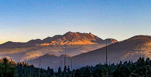
There is another route, more demanding, to directly reach the Pico del Fraile, the true summit of the Xinantécatl Stratovolcano, colloquially called Nevado de Toluca, located at an elevation of 4680 meters above sea level, although the data varies depending on the source that is consulted. The way to summit from Mexico City, or Toluca, is described. However, a stopover is also included, halfway up Cerro Prieto, which appears as a volcanic dome at the northwestern end of the volcano.
Getting There
Of course, the easiest way to get there will be by car. In this case, you must reach the city of Toluca, which is the capital of the State of Mexico, one hour from Mexico City. The park is still about 40 kilometers from the city, and the easiest thing will be to use Maps to find the way, looking for the Parque de los Venados, on the slopes of the volcano. The closest town is Raíces, at 3,600 meters above sea level, which makes it the town with the highest elevation in the country.
By public transport, it is relatively easy, but it has the disadvantage that it leaves you on the detour to the park, so you would have to walk about 4 km to the entrance. By bus, from Mexico City, you should go to the Poniente Bus Terminal, in Observatorio. One line, called Zina-Bus, offers departures every hour to Sultepec, a picturesque town in the state; The important thing is that this transport leaves you in the deviation towards the entrance of the Parque de los Venados, paying more or less $ 150 mxn (all prices are in mexican pesos), and with a trip that lasts around two hours. If you are in Toluca, go to the Terminal, to the same transport line, and buy the ticket to the same intersection to Parque de los Venados, which costs less than $ 50. Another option is the taxi, but I do not know the costs, and the security that it can offer.
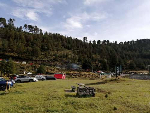
If you get to the intersection, you will have to walk a long dirt road, until you reach the Park, where the parking lot, bathrooms, shops and restaurants are. If you drive a car, you will be charged a fee of $ 50 or $ 60, I do not remember the data well. You will also have the possibility of taking a van to the camp near the crater, which is not necessary on the way if you decide to take this route, but it is the best option to take back from the end of this same route, since that same transport with the same rate can lower you from that camp at almost 4200 meters above sea level.
Route Description
The trail begins in the Parque de los Venados. You actually have to walk on the main unpaved road, which winds slightly ascending towards the southwest. Around it is only a pine forest, with several beautiful herbaceous plants, depending on the time of year. After almost a kilometer and a half, there is a path that turns southeast, towards the volcano, invisible from that point. The trail slightly increases its slope. On some days, the presence of vans carrying groups of hikers is what will indicate that you have arrived. The forest is somewhat denser, and of course the path is narrow, but quite enjoyable.
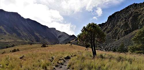
After crossing an intermittent stream, full of tall, thorny plants (they only add beauty to the landscape), a small but somewhat sloping uphill begins, which after a few minutes takes you to the edge of the forest. The Parque de los Venados rises to approximately 3700 meters above sea level, and the forest boundary at almost 4100 meters above sea level.
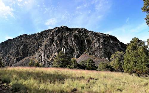
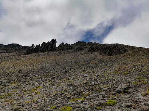
That was the beginning, in the zacatonal that extends over the limits of the forest, the path continues clearly, from there you will have a beautiful view of Cerro Prieto, imposing, covering the west, while Xinantécatl is the huge collapsed volcano in front. On a clear day, you can see the entire route to Pico del Fraile. Trees will become scarcer, and there are huge rocks on the road approaching the valley between the two mountains. The path will turn into a steep slope, approximately 100 meters of unevenness, because at the end of this climb, you can take a break. The top of Cerro Prieto is at 4320 meters above sea level, and offers an excellent panoramic view of the Toluca Valley and the Nevado de Toluca Park, while you can rest quietly on the plateau. But don't delay, because the difference between that location and Pico del Fraile is still almost 400 meters in vertical distance.
If you climbed Cerro Prieto, now you must descend, and again follow the path that clearly follows the contour of the northwest ridge, of which the end will frequently be lost from sight, at the same time that, permanently, and to the left, is the the one that apparently dominates the mountain. It is a heavy slope, due to the total exposure to both sides of the weather elements, but with good physical condition it is quick to overcome. In addition, the points where you can rest relatively comfortably are frequent as you overcome the secondary slopes, crowned by a multitude of weathered stones.
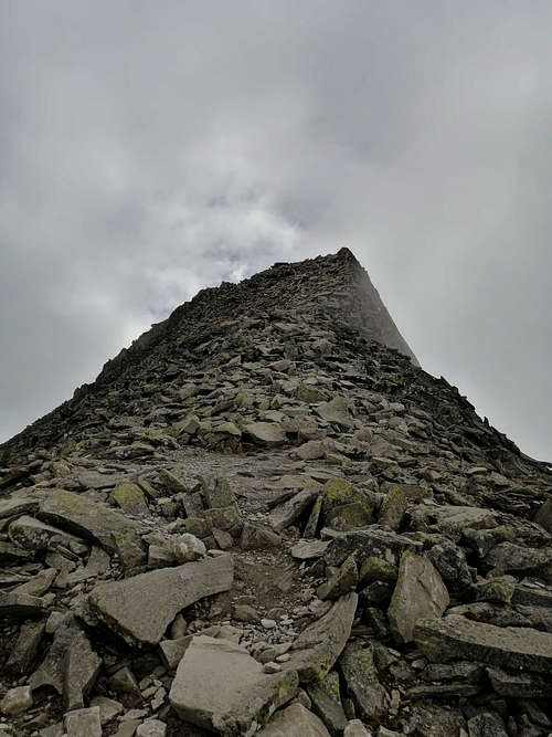
At the end of this slope, it intersects with the ridge that delimits the volcano to the north, and reveals the large crater, iconically occupied by two lagoons, and the "Ombligo" (navel) in the center, as it is an authentic plug of lava, that blocks the way to the magma chamber. Well that's what is in the crater ... at ~ 4200 masl, you are at ~ 4600 masl. What remains, to reach the true summit, is to turn to the right, and walk with caution, because the floor is now a narrow field of chaotic rubble, and the rocks are flat, with sharp edges. The Pico del Fraile is that huge pile of rubble randomly arranged in a sinuous horn. Technically, it is a quiet lvl III climb, with a rather small upper space, some stones stacked at 4680 meters above sea level.
Depending on your interests, your ability, and the level of fatigue you suffer, there are three alternatives. The first is to return to the Park where you came from. I, instead, and also if your time does not pass noon, or one o'clock, I would prefer to descend towards the lagoons and from there walk to the camp, where the transport that charges $50 to go up, the same as $50 to go down.
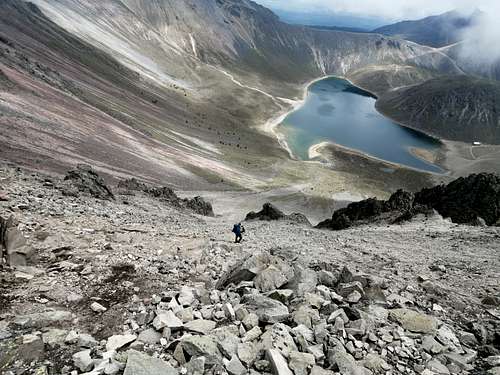
There are two ways to go down to the lagoons. The first consists of continuing along the ridge, heading for Pico de Aguila, towards the east, which was visible on the ascent, since it is evident that the ridge is frankly descending towards the lagoons, but clearly bordering the elliptical crater of the volcano. It is the best alternative, and the path is very clear. You will reach the Humboldt Ridge, where you can choose to descend to the lagoons and comfortably rest there, or cross the "Salto del Quetzal", to go down and take that transport to the Parque de los Venados, which is ultimately the end point of this route. But the most challenging and dangerous way to descend directly from 4680 meters to the lagoons is to do it with a lvl IV and III climb, descending through the steep slope, full of stones of all sizes, which represent a latent danger. If you do not have knowledge of descents on rough rocky terrain, or climbing, it is not recommended, as well as lacking protective equipment, mainly a helmet.
It is a tiring descent, and stressful, but fleeting unlike the other route, and you will arrive directly to the coast, with the "Navel" in front of you. To get out of there, just skirt the lagoon towards the west, there will be a climb, to be able to descend tenderly, on the dirt, to the camp and walk down, or better approach the transport for only $50.
Either way, the gpx file is on this page, or if you want to make the journey, I can gladly share the track in kml or gpx format.
Essential Gear
Without a doubt, the most important thing is clothing. Try to use the widely used layering system, removing or adding as appropriate. Mountain footwear is essential, preferably high-top boots, due to the large amount of dirt and stones that could hurt the lower extremities. Wearing a helmet is also important, and its importance will depend on the type of descent or ascent you decide to execute. UV glasses are highly recommended, indispensable if there are snow conditions. Under the same conditions, it would be essential to carry crampons and ice ax, along with rope. There are numerous potential sites for climbing, which requires technical preparation, and all the instruments.
Bring enough water.
External Links
Nevado de Toluca Weather Forecast.
https://www.mountain-forecast.com/peaks/Nevado-de-Toluca/forecasts/4632