The Trip
My brother John and I decided that Notch Peak in Utah's west desert would be our next objective to tackle. Because it was winter we wanted do something that wouldn't be too epic, but something fun to do on a weekend. President's day weekend was ideal for us.
We left Provo about 7:40 PM on Friday night not knowing what time we would arrive at the trailhead. Because it was pitch black outside we relied on getting there by GPS coordinates taken off topo map software. We made great time and passed through Delta and got onto the highway heading straight to Nevada. Highway 6 is long and straight, at night with the highbeams on we could see the reflectors for nearly a mile ahead of us and nothing else.
The GPS coordinates were very helpful in finding the right dirt roads, this was mainly because it was night and we had never been there before. If you arrive during the day there would be no problem because you would be able to see where you are going. We took a dirt road between mile markers 48 and 47. If you miss this turnoff, there is another turnoff a mile up the highway that connects on to the one we took. I believe there is a sign at the second turnoff announcing that you get to Notch Peak by taking it. Two miles after taking any one of these dirt roads you come to the left turn for Miller Canyon. We took this and went another few miles to a small parking area with a pit toilet. To the left there is a sign for Sawtooth canyon and another small dirt road, we took this until we reached the cabin several miles away. The cabin is easy to get to and finding your way there should not be a problem. At the time we were there, the dirt road to Sawtooth was covered in less than an inch of snow, which did not create any problems, though only a four wheel drive vehicle would make it, due to the roughness of the road. Without snow in the summer it would be easier but still rough.
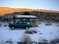
We arrived at the cabin at about 10:30 PM, not bad considering we had never been there before and did not know the roads. When we got out to stretch our legs, we could see millions of stars in the sky, it was amazing! I have never seen so many, not even on a clear night in the Uintas. It was definitly a highlight of the trip to see the heavens displayed so beautifully. After taking in the stars we set up our sleeping bags inside the cabin for the night. The door was unlocked and we assumed that it was okay to use it. The inside was covered with plywood on a dirt floor, animal droppings and a decrepit old cast iron stove. Some might find it disgusting but we cleared a way the best spots with our boots and it was actually quite comfortable inside.
![Notch Peak]() The cabin in Sawtooth Canyon
The cabin in Sawtooth Canyon We awoke a little after 7:00 AM, packed away our sleeping bags and ate some breakfast. We hit the trail about 7:40. It is possible to drive nearly a mile past the cabin to a road block and start hiking there, we didn't know this so we started from the cabin. It is a flat road and we made good time. The trail enters a high walled narrow corridor that leads to upper Sawtooth Canyon. After leaving the corridor you come to a fork in the canyon. I have provided GPS waypoints to help, and it is also obvious where the split is. We took the left fork which leads to a drainage. For the first two miles from the cabin to this point we had encountered several inches of snow on the road, after entering the drainage the snow became nearly ankle deep, which was annoying but not too much of a hindrance. We followed the drainage to where it narrowed and headed west.
![Notch Peak]() This is what you should see after branching left into the drainage.
This is what you should see after branching left into the drainage. We hiked through some deep snow and decided we did not want to continue following through it so by consensus we decided to hike straight up the south facing slope which was not covered in any snow to gain a ridge that lead to the summit. Though steep, the slope was easy to negotiate with some minor scrambling up rock ledges. Once we topped out the views were awesome! To the west we could see the summit, to the north we could see Swasey Peak, and to the east Mt. Nebo could be seen with its white snow capped summits. Also the Tushar range was visible as were the ranges to the south. It was a warm, clear February day, and we had at this point stripped down to only t-shirts to hike in.
![Notch Peak]() Looking west at the summit.
Looking west at the summit.From this point on the ridge it was clear how to get to the summit and with no trail to follow we made our own path through the snow and junipers. Along the way we encountered several rocky portrusions that needed to be climbed over. At other sections we encounterd thigh deep snow drifts which made us expend more effort than we expected. I failed to take my gaiters and I woefully regretted it as we trudged through the snow, they were invented for a reason. Squishy boots are very uncomfortable when hiking. As you get higher you can see the summit, but it's impressive north face is not yet visible from here. Just before getting to the last slope that leads to the summit there is a knoll that is in the way. You can traverse around the right or to the left. We decided on taking the right side which led us into a spectacular grove of bristlecone pines. I don't know how old these ones are but you can't help but wonder about how long they have stood there, and how many seasons they have lived through and survived. I highly recommend hiking through them, they are fun to see and they lead directly to the cliffs which open into the view of the huge north face. We encountered waist deep snow drifts here that made progress frustrating, but we persevered and made it to the overlook. You have to see it in person to feel the height and depth of this amazing cliff and gorge. It is breathtaking.
![Notch Peak]() North Face of Notch Peak.
North Face of Notch Peak.
From this point it is a short hike to the summit, nearly 300 vertical feet higher. We did not have any snow on this part to stop us and we made it up pretty quickly. One thing I hate about climbing mountains is that you can't control the weather. All day long we had hiked in bright sunshine and a cloudless sky. When we summited a lone cloud had formed on the summit, which obscured our views to the west. At points it would clear to give us views of Wheeler Peak and Ibapah, even though it was disappointing not being able to have a clear view, the mist made great frames for pictures of nearby peaks. We took nearly 20 minutes on top to celebrate before heading down.
![Notch Peak]() On descent looking east.
On descent looking east.On the descent we took the same route we used to get up and we descended rapidly. It had taken us nearly 4 hours to get to the top(we are not speed hikers and with snow in our way, we felt that we made great time to the top). On the descent, the time from the summit to the cabin was 2 hours, half of what it took us to get up. In total it took us 6 hours. I would say this is an average time for any group to summit and return to their vehicle at any time during the year.
We had a great time, and with perfect weather we made it to the summit without any problems. I recommend studying the topo maps for the area before going, to get an overview of what the terrain is like around the peak. Navigation was easy and not a problem for the whole trip. Being winter we did encounter snow, which I think could have been deeper if the snow pack for 2007 was not so bad. Notch Peak is a fun mountain to climb and not a disapointment in any way, shape or form.
GPS Waypoints
I am providing these waypoints as a help. They were accurate enough to get us to the mountain and back without any trouble. I have provided them in UTM/UPS grid format with NAD27 Datum.
Turnoff: 12S 0308150, 4326870
Miller Canyon: 12S 0308110, 4331440
Sawtooth Canyon: 12S 0300620, 4334810
Cabin: 12S 0296820, 4333570
Drainage Splitoff(head left): 12S 0294910, 4334050
Ridge Ascent(head up south slope to ridgetop): 12S 0293820, 4333958
Summit: 12S 0291840, 4335210
These are basic waypoints to reach the summit. Once you get on the ridge, you can clearly see the way to the summit and navigating is not hard. Also, after reaching the drainage there is no trail, the rest of the climb will be cross-crountry so it is important to know basic navigation skills. It is always good to carry a topo map of the area and a compass to rely on if you need to. We carried both but did not need them at any point.
Miscellaneous
-We did this hike in February. There was snow to deal with but it was never more than knee deep except for when we made it to the Bristlecones where the snow was waist deep and easily passable. I would expect even more snow than what we encountered during a normal snow pack for the winter season.
-It seems that there really never is a reliable water source anytime during the year except maybe for a short time during spring runoff
-We slept in the cabin, if it is private property I am not aware of it. We found no lock on the wood door and decided that it would be alright to sleep inside. If you do decide to take shelter inside, please do not deface or vandalize the property, some people have already broken out windows and littered around the cabin.
-This is a strenous hike but not overly demanding. Proper equipment and physical fitness is a must for a successful trip.
-We made the trip an overnighter by driving from Salt Lake City to the trailhead in about 3.5 hours on a Friday night. We left after work and it worked perfectly for us.
-I have posted all the pictures of our trip on
my web album


Comments
Post a Comment