|
|
Mountain/Rock |
|---|---|
|
|
49.42808°N / 20.13346°E |
|
|
Hiking, Sport Climbing, Toprope, Bouldering |
|
|
Spring, Summer, Fall, Winter |
|
|
2257 ft / 688 m |
|
|
Overview
|
||||
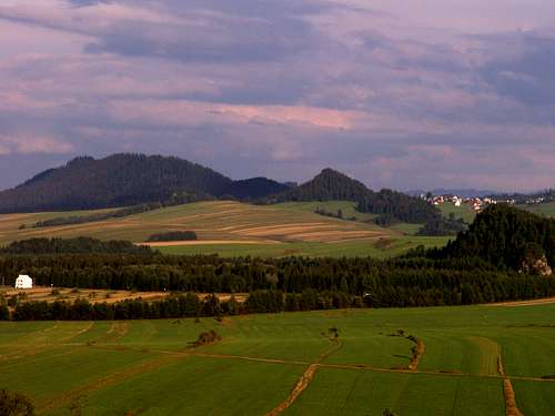
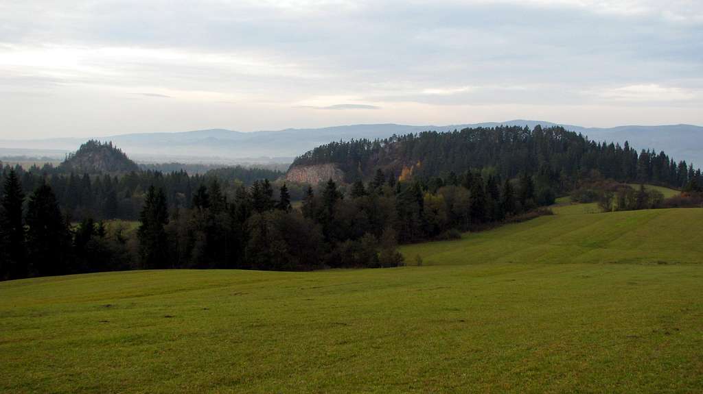
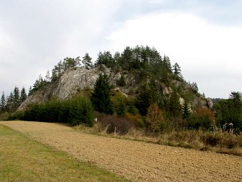
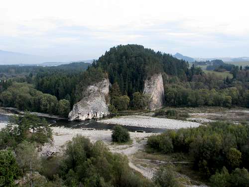
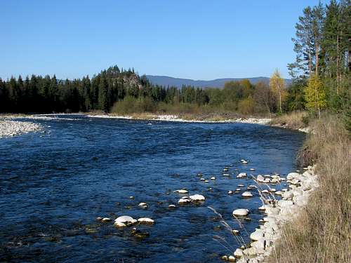
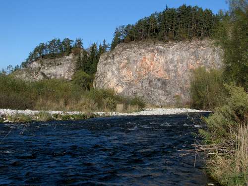
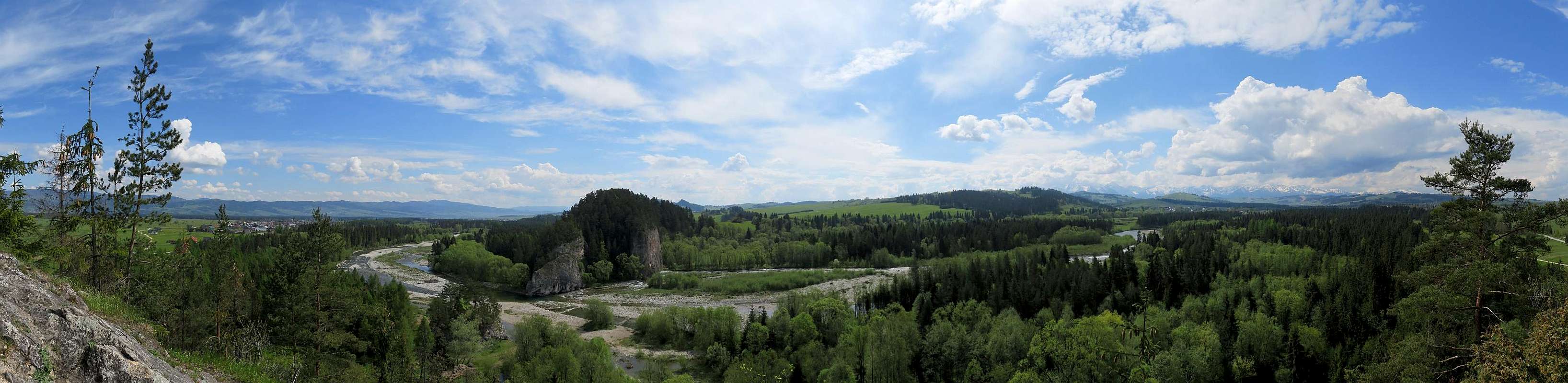
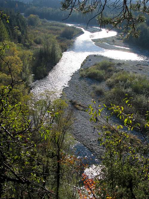
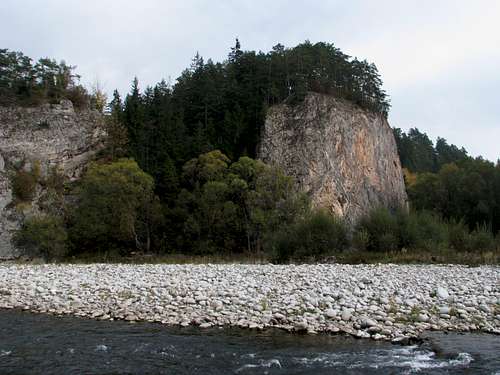
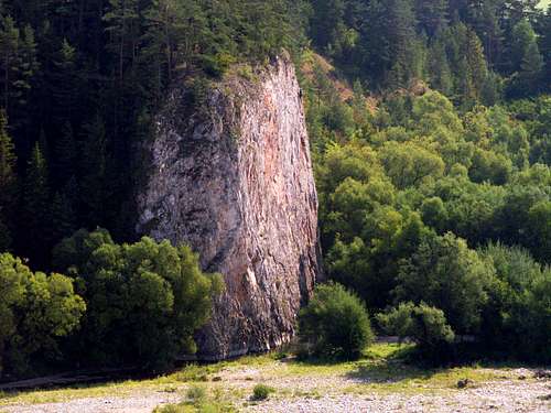
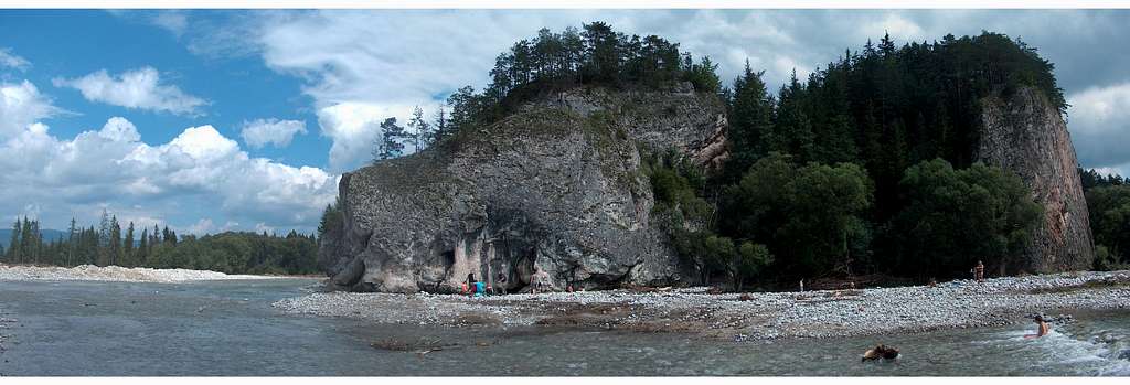
| Several kilometres before discharging into the Dunajec, the River Białka flows between two rocky hills. The hills belong in the western reaches of the Pieniny Spiskie, formed of limestone, wooded and jutting out like islands from a sea of flysch covered with meadows and fields. The pretty round hill on the left (west) bank of the Białka is called Obłazowa and tops out at 670m, whereas the elongated hill on the east bank is known as Kramnica and reaches 688m. Both hills can be easily climbed as they only rise about 50m and 65m respectively over their foot. The easiest routes are not more demanding than YDS Class 2. Obłazowa is more easily accessible than Kramnica and it also offers a little better views. On the other hand, you are more likely to find some solitude on Kramnica. As the limestone forming Kramnica and Obłazowa is reddish in colour, the locals call the hills Czerwone Skałki, which translates as Red Rocks. It seems to me that this name is slowly falling into disuse though. Both hills compose a nature reserve whose official name is Przełom Białki pod Krempachami (the Białka Gorge at Krempachy). | ||||
|
Getting There & Hiking Routes
|
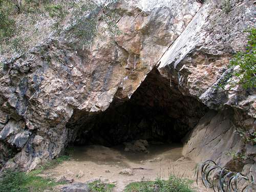
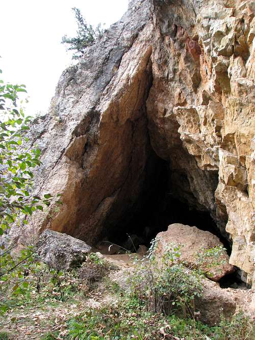
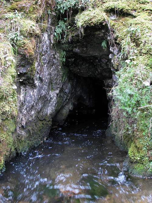
I do not think you are likely to travel from afar just to climb these hills, however, while on holiday at the foot of the Tatras you may feel like paying them a visit. To get there from Zakopane, take the main road for Kraków (#47). At the first village (Poronin), just after passing the first bridge, turn right and head for Bukowina Tatrzańska. At the roundabout in Bukowina take the first exit to the left, then drive down to the other end of the village, where you will see the River Białka on your right. Do not cross the river but carry on straight, through the adjacent village of Białka Tatrzańska. About 1km after the church, at the junction, bear right into a narrow street. Drive out of the village, then straight through the crossroads. After 2km you will see Obłazowa on your right, just by the road. There is a car park (which used to be a field) at its very foot. The fees, about $1 per car in 2013, are collected by a local lady who also tends to her cows grazing nearby. To get to this place by public transport, take a minibus heading for Białka Tatrzańska or Czarna Góra Zagóra. Get off at Białka Grapa (near the end of the village), then continue down the road on foot for about 3km. From the car park at the foot of Obłazowa, walk along the path across the adjacent field to a short, well-trodden path leading to a use trail circling the hill. If you follow the trail skirting Obłazowa in the anticlockwise direction, you will soon pass three shallow caves. The first cave is not to be entered as it is an extraordinary archeological site, still being dug. In this cave a unique, probably the world's oldest known boomerang was found, made over twenty thousand years ago of mammoth tusk. The second cave doesn't seem to be very interesting, unlike the third cave, whose entrance serves as a rock climbing spot providing a route which is both extremely short and extremely difficult.
The shortest way to get from the foot of Obłazowa to the foot of Kramnica is wading across the river. At low water it should be easy to find a suitable ford nearby so that your shorts can remain dry. Bear in mind the boulders in the river can be surprisingly slippery. The northern foot of Kramnica is terribly muddy near the river so it is wiser to make the crossing south of the hills, that is to say upstream.
If you want to cross the river dry-shod, there are two bridges nearby, downstream and upstream, each about two kilometres away. To get to Kramnica as close as possible by car, cross the bridge downstream, between the villages of Nowa Biała and Krempachy, then turn right at Krempachy along the road heading southwest. The road, which soon turns into a dirt road, will lead you just east of Kramnica, a few minutes’ walk from the hill. You can leave your car by the road. On the downside, it is rumoured that some cars parked there have been broken into.
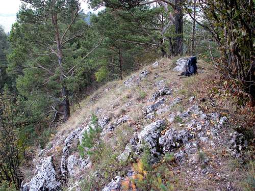
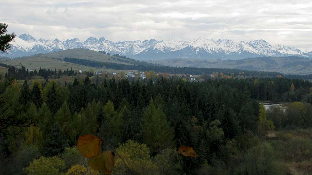
From the road walk across the meadows towards the east end of the forested ridge of Kramnica, which stretches from west to east, then – still heading west along the north foot of the hill – look for a path dipping into the wood, then running up to the crest. The path will lead you along the top of the mountain – which makes for a rocky but wooded crest of limestone, a couple of metres wide – past its highpoint as far as you want to go (to the other, west end of the mountain by the River Białka if you like), from time to time offering a view north (to the village of Nowa Biała beyond the river and the Gorce Mountains on the horizon) and finally a panoramic vista of the Tatras rising about twenty kilometres to the south.
|

Red Tape & Rock Climbing
|
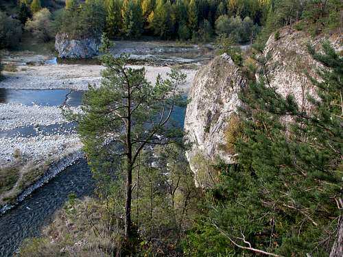
There are several rock climbing routes on Obłazowa but the finest climbing is to be found on the south-facing crag of Kramnica which is situated right by the river. The topos can be seen here. The problem is that the area is a nature reserve in which rock climbing is officially forbidden. Nevertheless, all the routes have been bolted in recent years and rock climbing seems to be tolerated by the occasional ranger as long as it is not accompanied by littering, camping or making bonfires.
|

Maps
Several versions of the paper map are available in bookshops in any of the nearby towns.
When To Go
In summer, except for September, expect crowds of holidaymakers sunbathing by and dipping in the river. There will be far fewer visitors in May, the first half of June, September, not to mention October.
| There are a good many guesthouses and other types of accommodation in the nearby villages and towns, e.g. Zakopane. When booking online, I usually use this site. | ||
|