
|
|
Mountain/Rock |
|---|---|
|
|
36.42387°N / 117.41239°W |
|
|
Hiking |
|
|
Spring, Fall, Winter |
|
|
2700 ft / 823 m |
|
|
Overview
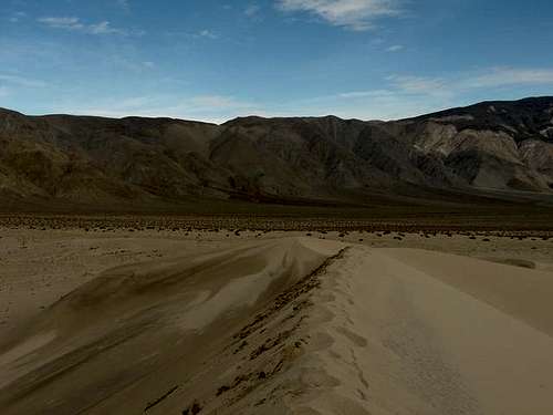
 Looking back from the dunes to Telescope Peak
The Panamint Dunes are a small and compact area of dunes located at the northern end of the Panamint Valley. The dunes top out at an elevation of around 2700' which is a figure that changes with the wind. With a prominence of around 400', they are also among the tallest dunes in Death Valley though trailing the "world-famous" Eureka Dunes by 300'.
Due to its remoteness, the dunes are rarely visited and are, thus, almost always in pristine quality.
Getting There
 Getting to the dunes takes plenty of time.
The Drive
The summit of the dunes is located 4 miles from the nearest road with the base located 2 miles from it. That road, the Big Four Mine Road, is located on the western section of CA-190 just east of Panamint Springs and Panamint Dry Lake. The road is unsigned (as of November, 2008) and may be washed out after rain.
Continue up until the road makes a right turn away from the dunes (visible in the distance) and park along the side of the road.
The Hike
Despite its apparent closeness, the dunes require a 1 hour hike to reach. There is no defined trail (due to sand) so the best way to reach it is to pick the nearest route by heading straight for the highest dune (on the right).
The Climb
Getting to the dunes is only half the adventure. Climbing it is really something else.
The going gets slower after reaching the base but continue straight on through the sand. The base of the highest dune is where things really get tough. Head for a ridge rather than climb straight up to save energy for the return.
Restrictions
 No motorized vehicles allowed on the dunes!
Only foot traffic is allowed. No suitable camping spots around the dunes. Also, dogs are not allowed off the road.
Bob Sihler - Nov 11, 2008 7:02 pm - Voted 10/10
Dunes photoYou might want to attach this photo: http://www.summitpost.org/view_object.php?object_id=238319. It is not mine, which is why I can't just attach it myself.
Cedar - Nov 15, 2008 11:42 am - Hasn't voted
Re: Dunes photoAttached and ready! Completely forgot about attaching my own images!
tarol - Nov 13, 2008 10:53 am - Voted 10/10
Great pageMight want to attach it to the Sand Dunes Page
Cedar - Nov 15, 2008 11:38 am - Hasn't voted
Re: Great pageDone! Thanks...
rice - Dec 29, 2009 2:12 pm - Hasn't voted
CAMPINGTHERE WAS A COUPLE OF SUITABLE AREAS TO CAMP NEXT TO THE ROAD JUST BEFORE THE ROAD TURNS MORE ROCKY. NEAR THE AREA YOU WOULD PARK TO START YOUR HIKE.