
-
 23545 Hits
-
 90.13% Score
-
 31 Votes
|
|
Mountain/Rock |
|---|---|
|
|
36.10300°N / 116.624°W |
|
|
6384 ft / 1946 m |
|
|
Overview
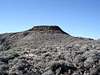
Funeral Peak is located in Death Valley National Park in the Black Mountains on the southeast side of Death Valley. Pyramid Peak (6,703 ft) is nearby in the Funeral Mountains. The picturesque overlook of Dantes View is about 10 miles north of Funeral Peak. Funeral Peak is ranked #33 in California in Prominence with 3,304 ft of prominence.The Black Mountains form the eastern side of Death Valley and the Panamint Range cumulating on Telescope Peak forms the western edge. The topology here is the basic Basin and Range formations in an arid desert environment. There are no trees on Funeral Peak or anywhere on the hike to the summit.
The views from Funeral Peak are good and you can see part of Death Valley to the west, however, the views from Dantes View are more spectacular because of the cliff face that Dantes View sits atop.
Funeral Peak is a great place to get away from civilization and people. To get to the summit you have to drive at least 12 miles on dirt roads and then hike crosscountry for 4.5 miles to the summit.
 |  |  |  |
Getting There
There are two ways to approach Funeral Peak. Both involve some dirt road driving, but a normal 2WD vehicle should be able to negotiate the roads. The dirt roads have been repaired and newly graded in 2005.If your travels take you through Shoshone, stop at the Crowbar Café and Saloon for a great burger and fries. They have other good food and pastries also.
Option 1 is from Highway 190 that connects Furnace Creek in Death Valley and Death Valley Junction or Amargosa east of Death Valley. From Death Valley Junction/ Amargosa where Hwy 190 and Hwy127 intersect, proceed west on Hwy 190 for 18.1 miles to a paved road on your left or south side of the road. If you are starting in Furnace Creek, proceed east on Hwy 190 for 12.1 miles from the Visitor Center and then turn right or south onto the paved road. This paved road has a small sign indicating Dantes View and the Billie Mine are accessed from this road. Proceed south 7.3 miles to a dirt road on your left. This is the Greenwater Valley Road and there is a sign that says Shoshone is 36 miles away. This is a good road and I drove 30+ MPH most of the way. Proceed down this dirt road 7.6 miles, stop, and pull off the road. Funeral Peak is on your right or west about 2 miles across the desert. You should be near the highest saddle on the Greenwater Valley Road. Don’t drive past this saddle.
Option 2 is from Hwy 178 that connects Furnace Creek and Shoshone. From Shoshone proceed north on Hwy 127 for 1 mile to and then turn left on Hwy 178 for 5.6 miles. Turn right or north on the dirt Greenwater Valley Road. From Furnace Creek it is a long drive through Death Valley, pass Badwater and at the south end of Death Valley Hwy 178 starts to climb out of the valley and you go over Jubilee Pass and Salisbury Pass. 4.9 miles from Salisbury Pass is Greenwater Valley Road on left or north. This is a good road and I drove 30+ MPH most of the way. Proceed down this dirt road 16.1 miles, stop, and pull off the road. Funeral Peak is on your left or west about 2 miles across the desert. You should be near the highest saddle on the Greenwater Valley Road. Don’t drive past this saddle.
Red Tape
Funeral Peak is in Death Valley National Park and there is some red tape.First, if you are coming from Death Valley you have to pay the $20 access fee to enter Death Valley.
If you are coming from the east on either Hwy 178 or Hwy 190, the Greenwater Valley Road is not in Death Valley and you don’t have to pay the fee because the fee stations are further down the road in Death Valley.
Camping is not allowed within 2 miles of either end of Greenwater Valley Road.
For more information contact Death Valley National Park
By Mail
Death Valley National Park
P.O. Box 579
Death Valley, CA 92328
By Phone
Visitor Information
(760) 786-3200
(760) 786-3241
By Fax
(760) 786-3283
When To Climb
Climbing Funeral Peak is best done in the Fall and Winter seasons. It can be DEADLY hot in the summer so be prudent.Camping
Camping is available in Death Valley at several campgrounds of varying quality.For more information follow this link: Camping
There are unlimited possibilities for backcountry camping in the desert. Just pick a spot off the road and out of a wash and have fun.
Mountain Conditions
Take precautions when climbing Funeral Peak. Don’t climb if thunderstorms are forecast or when the weather is too hot.Shoshone Weather
Death Valley Weather
Acknowledgements
Dennis Poulin was the original creator of this page and has asked me to take care of it. Thanks for all your contributions to the peakbagging world Dennis!I intend to make updates to the page in the near future. If you have any pressing information that needs mention, please let me know.