
|
|
Mountain/Rock |
|---|---|
|
|
36.90902°N / 117.59787°W |
|
|
Inyo |
|
|
8674 ft / 2644 m |
|
|
Overview
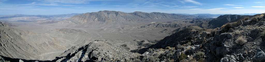
Dry Mountain is the highpoint of the remote Last Chance Range in Death Valley National Park which separates the Saline Valley, Eureka Valley, Racetrack Valley, and northern Death Valley. Aside from Racetrack Valley, this area is less frequently visited than the more tourist oriented locations further south in Death Valley. It makes for an excellent area to get away from the crowds and explore.The summit marks the fourth most prominent in Death Valley NP (and 26th in the state) with 3,614 feet of mean prominence. This, along with the peaks inclusion on the Sierra Club’s Desert Peaks Section DPS List, generates the motivation for many of Dry Mountain’s visitors. Though the hike takes a full day, it is technically easy (class 2) and well rewarded with scenic views of the desert, the Inyo Mountains, and the Sierra Nevada. There are many other sights worth visiting in the area to fill out a long weekend or week in the park, including the aforementioned valleys (Saline and Eureka Valley are highly recommended), a climb of nearby Tin Mountain, or many other sites including Ubehebe Crater, Ubehebe Peak, The Racetrack, Scotty’s Castle, Ubehebe Lead Mine north of The Racetrack, and the Lost Burro Mine in Hidden Valley.

Getting There
 Route Map
 Hunter Mountain Road
Dry Mountain can be climbed from either the east or the west (well, technically the south is also possible), but the eastern approach from Racetrack Road is the standard route due to its relative accessibility and easier driving. Racetrack Road's proximity to nearby Tin Mountain also plays a factor for those interested in making the trip to both peaks on successive days. Racetrack Road is unpaved but well graded (but often washboarded) and as of early 2011 it was not at all challenging for even low clearance vehicles (despite NPS warning signs specifying high-clearance requirements).
Racetrack Road (36.88165° N, 117.50406° W)
From Highway 190 in Death Valley head north on Scotty's Castle Road from just east of Stovepipe Wells. After 33 miles turn left at the signed junction to Ubehebe Crater bearing left again after 2.8 additional miles (this is where the drive from Big Pine/Eureka Valley joins). Continue west and then south following signs to The Racetrack. Follow Racetrack Road for 10.4 miles from the Ubehebe Crater loop to a point wide enough to park on the road, making sure you are fully on the roadbed.
Alternatively Racetrack Road can be reached from the south via Hunter Mountain/Hidden Valley Road. High clearance is needed for this route and four wheel drive is advisable over the Hunter Mountain area if there is any chance of wet or inclement weather, and it may be impassable for periods during the winter months (highest elevation is 7140 feet). There are excellent mining remains and dispersed camping opportunities throughout the drive and it is very highly recommended if you have the right vehicle.
To reach the trailhead via Hunter Mountain Road, head north on Saline Valley Road from Highway 190 east of the Darwin turnoff. After 15.7 miles bear right onto Hunter Mountain Road above Grapevine Canyon. Follow the main road towards Hidden Valley, keeping right at a fork seven miles from Saline Valley Road. There are several side routes to mines along the way, the highlight being the Lost Burro Mine in Hidden Valley, 21.5 miles from Saline Valley Road. The roads ends at Teakettle Junction on Racetrack Road 3.2 miles later. Follow Racetrack Road north for 9.1 miles to the trailhead area.
Route Description
 Dry Mountain from the Saddle at 7900 Feet
Trip statistics from Racetrack Road:
Class 2, 6.5 miles one-way, 4700 feet elevation gain out plus 700 feet on the return
Park at one of a few locations wide enough to remain on the road near the northern end of the small hills that lie immediately west of Racetrack Road in the vicinity. An intermediate ridge with a large drainage to the left (south) lies west of the summit and is visible two miles east of the trailhead. Begin by walking up the sloping desert around or over the hills near the trailhead in the general direction of the southern end of this ridge as shown on the route map. There are several routes up the ridge to a saddle visible at 7900 feet. It is generally easier to gain the ridge the further south you approach it. Follow the ridge north to the 7900 foot saddle just north of point 7944 where the true summit comes into view to the west. Cross the flat, broad saddle and follow the northernmost of two western ridges past point 7934 and drop 700 feet to the large wash below. From the wash it is a straightforward but steep ascent (1400 feet over one mile) up the east ridge of Dry Mountain. There are occasional but infrequent use trails, not really necessary due to the easy terrain and good visibility of the route throughout.
Red Tape
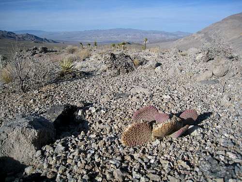 Desert Flora around Dry Mountain
Entrance Fees:
Dry Mountain is in Death Valley National Park and an entrance fee is required. Please see the Death Valley Fee Page for full details. Note that the fee stations are at the entrances to the main valley, and if you approach Racetrack Road from Hunter Mountain/Hidden Valley no fees are collected. The drive to the west side of Dry Moutain via Saline Valley also lacks entrance fees.
Wilderness Permits:
Wilderness permits are not required but backpackers may obtain them for free at the Furnace Creek Visitor Center or Stovepipe Wells Ranger Station.
Campfires:
Campfires are prohibited in Death Valley outside developed campgrounds.
Death Valley National Park
P.O. Box 579
Death Valley, California 92328
(760) 786-3200
Current Conditions
Current NOAA / National Weather Service ForecastWhen to Climb
This is the California desert and trips are best done in the cooler months of fall, winter, and spring. In the winter months some snow is periodically present at the higher elevations, but generally will not be an obstacle unless attempting to drive in from the Hunter Mountain/Hidden Valley direction. Snow and ice can make the drive over Hunter Mountain (elevation 7140 feet) impassable during portions of the winter months.
 |
 |
 |
 |
 |
 |
Camping
 Dry Mountain from Ubehebe Peak
One of highlights of Death Valley National park is dispersed camping. Roadside camping is permitted at the trailhead vicinity on Racetrack Road, throughout Saline Valley, and at most other locations at least two miles from the nearest paved road (but be sure not to pull off the road along Racetrack Road). Exceptions to dispearsed camping include some high use areas and portions of the Death Valley floor and Racetrack Road from Teakettle Junction south to Homestake Dry Camp near The Racetrack, for complete details see the Death Valley Backcountry Camping Page. Be sure to bring enough water for the duration of your stay if dispersed camping.
There are also numerous locations for established campgrounds throughout the park. Mesquite Spring near Scotty's Castle (full amenities) and Homestake Dry Camp south of The Racetrack (very primitive, bring water) are the closest options. More details are on the Death Valley Campgrounds Page.
Etymology
“There are more than one hundred Dry Creeks and about twenty-five Dry Lakes in the state, together with an assortment of Dry Sloughs, Gulches, Valleys, Arroyos, and Lagoons. Most of these were named in the dry season; very few are dry all year round.” – Erwin Gudde, William Bright, California Place Names (2004)The above description certainly applies to Dry Mountain. Best climbed in the winter, the summers can be oppressively hot and there are no water sources in the vicinity. The cooler months, however, bring precipitation. Though you remain unlikely to encounter any water, it is not uncommon to encounter small amounts of snow at the higher elevations.