
|
|
Mountain/Rock |
|---|---|
|
|
37.99310°N / 107.59815°W |
|
|
Ouray |
|
|
Mountaineering |
|
|
Summer |
|
|
13132 ft / 4003 m |
|
|
Overview
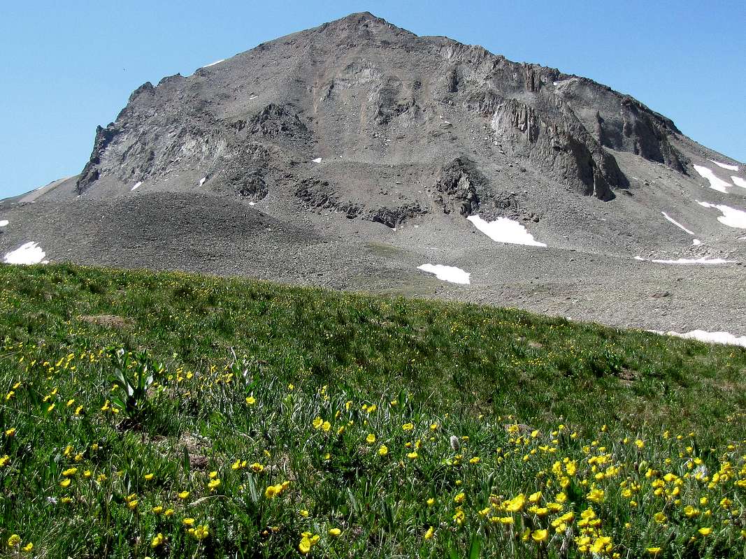
North face of Peak 13132 ft
Name: This peak is officially unnamed.
Rank:: Peak 13132 ft is Colorado’s 543rd highest ranked peak.
For more information about Bear Creek Trail, see this Summitpost Page.
Peak 13132 ft rises at the eastern end of Bear Creek Canyon in the San Juan Mountains of southwestern Colorado near the town of Ouray. Bear Creek Canyon is a spectacular gorge with sheer walls that rise hundreds of feet above Bear Creek. In the late 1800s, gold and silver were discovered in the upper portions of Bear Creek Canyon. In order to access the mines, a trail was carved into the walls of the canyon. This trail has now turned into a popular hike that takes you from Route 550 to the remains of Grizzly Bear and Yellow Jacket Mines giving you fantastic views of the canyon. To reach Peak 13132 ft, you must leave the trail at Yellow Jacket Mine and hike up another 2000 vertical feet. This creates a strenuous but scenic 12.7 mile roundtrip hike with more than 4600 ft of vertical.
A much easier way to reach Peak 13132 ft is to drive the Engineer Pass Jeep Road to the 12800 ft Engineer Pass. You can then hike to the top of the 13260 ft Darley Mountain, or bypass it over the 12600 ft high American Flats Plateau, to reach the base of the eastern ridgeline of Peak 13132 ft. Such an approach will obviously require much four wheel driving and much less hiking.
West face of Peak 13132 ft from Bear Creek Trail between Grizzly Bear & Yellow Jacket Mines
Getting There
Directions to Bear Creek Trailhead:From the south end of Ouray, drive 2 miles south on Route 550 and go through the small tunnel. Immediately on the south side of the tunnel you will see a parking area and sign for Bear Creek Trail.
Route, via Bear Creek Trail

Map
All distances are per my GPS. The sign at the trailhead says 2.4 miles to Grizzly Bear Mine and 4.2 miles to Yellow Jacket Mine.
At the parking area, go to the west side of Route 550 at the southern entrance of the tunnel and find the Bear Creek Trail. The trail takes you right over the top of the tunnel. Abrams Mountain will be well visible to the south.

Abrams Mountain from the top of the tunnel
The trail goes into a forest and makes many switchbacks going up a steep slope. Whitehouse Mountain and Mount Ridgeway will at times come to view.

Whitehouse & Ridgeway Mountains
As you go higher, trees go away and the trail can be seen as a pathway carved into the steep rocky slope.

Trail
At some of the switchbacks, you can look north to see the town of Ouray and parts of Route 550. You may feel like a rock climber far up a wall.

Town of Ouray & Route 550
The Red Mountains can be seen to the south.

The Red Mountains
Another view of Route 550.

Route 550 far below
After 1.1 miles and 1000 vertical feet up, the trail turns east and enters Bear Creek Canyon far above the bottom of the canyon. For the next half mile or so, the trail appears as a pathway dug into the walls of the canyon. This is the most dramatic looking part of the hike.

Trail carved into the wall of the canyon

Bear Creek Canyon

Bear Creek Canyon

Bear Creek Canyon

Bear Creek Canyon
As you keep going, the bottom of the canyon begins to rise getting closer to the trail. A forest of Aspen Trees appears. You will then reach the remains of Grizzly Bear Mine.

Remains of Grizzly Bear Mine
The 2 miles between Grizzly and Yellow Jacket Mines consist mostly of an Aspen forest. The trail stays near the bottom of the valley.


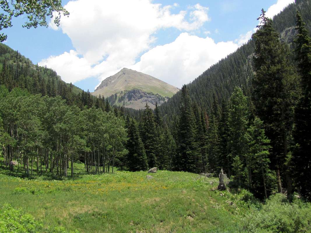
Peak 13132 ft finally comes to view to the east but as you keep going, it goes out of view again.

First view of Peak 13132 ft, west face
To the west the jagged summit of Mt. Sneffels and its entourage appear.

Mt. Sneffels
You will then reach the remains of Yellow Jacket Mine. If you continue on the trail a short distance toward Engineer Pass, you will see this pretty waterfall.

Remains of Yellow Jacket Mine

Near Yellow Jacket Mine
A sign at Yellow Jacket Mine may point to Horsethief Trail & Engineer Pass Trail in the same direction. The USGS Map shows a trail that goes up the slope above Yellow Jacket Mine to enter the valley to the north of Peak 13132 ft. This trail probably branches off of the Engineer Pass Trail a short distance beyond Yellow Jacket Mine (and not directly above the mine). I decided to leave trail at Yellow Jacket Mine and went directly up a steep grassy slope to the east/northeast of the mine. Soon Peak 13132 ft and this rocky point came to view.

Peak 13132 ft

Rocky Point
More views of the Mt. Sneffels group to the west.

Mt. Sneffels/Potosi Peak
I was now in the grassy valley to the north of Peak 13132 ft. A trail appeared. I suspected that this trail separated from Engineer Pass Trail a short distance beyond Yellow jacket Mine.

Valley

Valley

Valley
As the north face of Peak 13132 ft came into full view, it appeared that its western ridgeline might be easier to climb than the eastern ridgeline. Grassy slopes, however, went much farther up on the approach to the eastern ridgeline so I decided to go up the grassy valley to reach the base of the eastern ridgeline of Peak 13132 ft.

North/northwest face of Peak 13132 ft

North face of Peak 13132 ft
Near the base of the ridgeline, it did not look promising.

Base of the eastern ridgeline
At 12700 ft, I reached a saddle at the base of the eastern ridgeline. Great view of Darley Mountain appeared to the south.

Darley Mountain
The hike up the ridgeline turned out to be not bad at all. Some scrambling needed among the rocks.

Eastern ridgeline

Climbing the eastern ridgeline

Climbing the eastern ridgeline
Views from the summit of Peak 13132 ft:

Mt. Sneffels & Bear Creek Canyon

Uncompahgre & Wildhorse Peaks

Looking SW, Red Mountains

Looking SE

Darley Mountain

American Flats Plateau