
-
 4841 Hits
-
 76.66% Score
-
 7 Votes
|
|
Mountain/Rock |
|---|---|
|
|
34.70402°N / 117.573°W |
|
|
San Bernardino |
|
|
3996 ft / 1218 m |
|
|
Overview
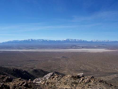
Peak 3996 is the highpoint of the southern half of the Shadow Mountains. The summit has extensive views of the western Mojave Desert and especially of El Mirage Dry Lake. It is a great peak to combine with trips to Shadow Mountain (Highpoint) and Silver Peak. This peak is best hiked in the cooler months. Peak 3996 is on the San Antonio Cell with a prominence of P496.
Getting There
Take any freeway you need to connect with the Interstate 15 through the Inland Empire. Take I-15 north through Cajon Pass and take the Highway 395 from the junction. Take the 395 passing the town of Adelanto and continuing for about another ten miles to the the junction with the unpaved, but passenger car fiendly, Shadow Mountain Road. Turn left(West) onto this road and take it for about 7 miles passing through the mostly abandoned town of Shadow Mountain. On your right (north) you will see the crest of the northern Shadow Mountains and on your left will be the southern hald of the range. When you reach a abandoned house with a road just to the west of it, keep going about a mile or two more and park on one of the many turnouts on the left side of the road.Route

From the road hike south across open desert country straight to the high summits. Gain the rocky peaks and transverse over to the highpoint, the second one south of the neighbor peak you first gained.
Roundtrip is 3 miles with 800-1000 feet of gain.
External Links
Weather UndergroundFor road and highway information in San Bernardino County.