
-
 27622 Hits
-
 79.04% Score
-
 10 Votes
|
|
Mountain/Rock |
|---|---|
|
|
34.67490°N / 116.8151°W |
|
|
Hiking |
|
|
Winter |
|
|
6309 ft / 1923 m |
|
|
Overview

The Ord Mountains are the most prominent range in the western Mojave desert. The highpoint of the range, Ord Mountain 6,309 feet, is the 36th most prominent peak in California with a value of P3253. The range is made of three prominent but isolated summits. West Ord 5,525 feet forms the western arm of the range, in the middle is Ord Mountain, and forming the eastern arm is East Ord Mountain 6168 feet. The Ord Mountains ara weathered rugged volcanic range made of mostly andesite and dacite. The Ord Mountains have been mined heavily for gold, silver, and copper. Throughout the range mines litter the slopes of the rugged peaks. The range was named after General O.C. Ord who lead the first survey of the Los Angeles area.
Getting There
 |
 |
 |
From I-15 in Victorville take Highway 18 east to Apple Valley. Drive 23 miles on the 18 reaching the 247 junction. Take the 247 east for 5 miles reaching Camp Rock Road. Go north on Camp Rock, at 14 miles stay to the left at a fork, and continue 8 miles. At this next junction, I believe is road 7526 turn left at after about .5 miles turn left at another junction. Take this road for 4 or more miles. Look for a bunch of mining roads on the west slope of Ord. Also look for the prominent notch. The roads are very confusing once you leave Camp Rock, they are poorly signed, be mindful you are trying to find the road that runs south along the western slope of Ord. There is only one road that does this I believe its number maybe 7525, but I didn't totally trust the signs.
There is a summit road to Ord, but I have no information on either it being gated or private use only.
Route
 |
 |
 |
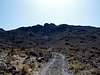 |
From the parking spot hike up the old mine road for .75 miles to the blueish pile of rocks. There is a mine on the left side of this pile, on the right side a use trail ascends up to a water tank area. Behind the water scramble up the steep slope to the prominent notch. Enter the notch, Class 3 rock, and ascend it to the ridge top. Watch out for knocking rocks loose in this area. From the top of the notch ascend the rocky ridgeline to the south. At the top of this ridge you will see the summit plateau and the true Ord Summit with towers. Cross the plateau going east, less then .5 miles, to a summit road used to service the summit towers. Take the road all the way up to the summit. The highpoint is just to the left of the towers. There was three survey markers but no register.
Roundtrip is 4-5 miles with +2000 feet of gain.
Camping
The Ord Mountains are managed by the Bureau of Land Management and primitive camping is allowed in the area. When camping out here be mindful of offroad vehicles driving potentially into your camp. Locate tents in a protective manner, like behind your vehicle, from potential offroad driving routes.The San Bernardino National Forest is not very far to the south and has many campgrounds, especially in the Big Bear Lake area.
Essential Gear
All the standard gear, but especially sun protection. Also extra water and food due to the remote nature of the dirt roads encountered. A breakdown could be a long nervous wait.External Links
For more information on the Ord Mountain Route Network go to this BLM link.For a interesting webpage on mining history in the Ord Mountains and San Bernardino County go to Empire.net.
gimpilator - Nov 5, 2015 6:10 pm - Hasn't voted
East Ord LinkIt appears as though the old East Ord page was deleted for some reason. I have created a new one (http://www.summitpost.org/east-ord-mountain/958615). Please update the link on your page.