
|
|
Mountain/Rock |
|---|---|
|
|
40.72881°N / 111.64358°W |
|
|
Salt Lake County |
|
|
8281 ft / 2524 m |
|
|
Overview
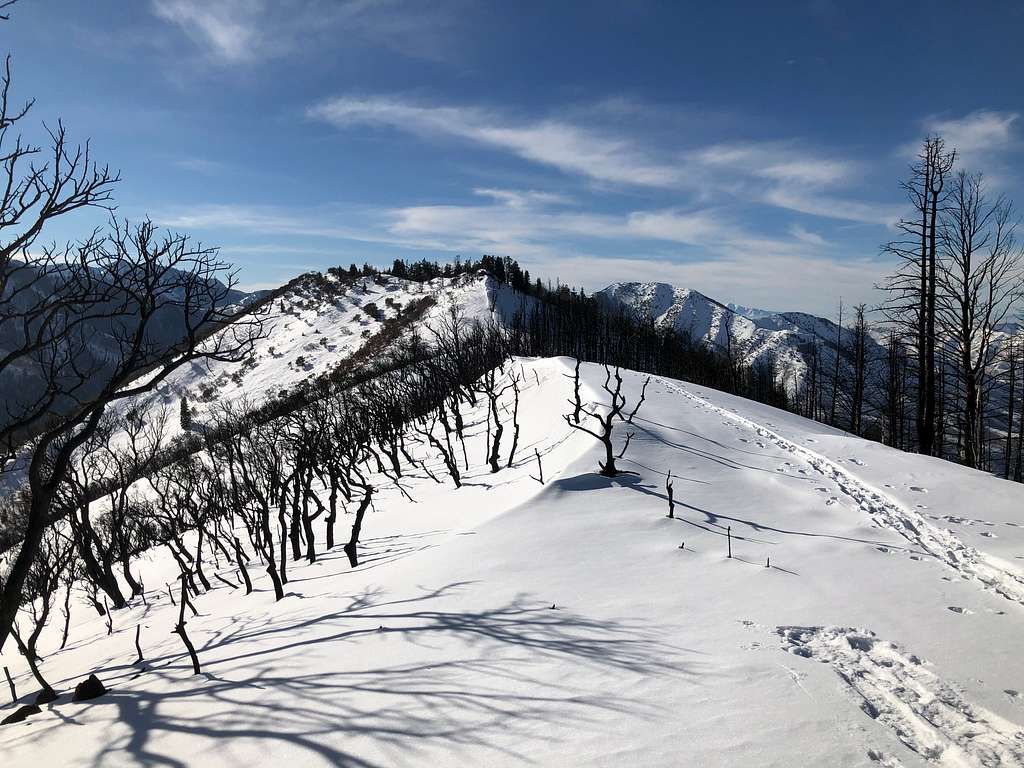
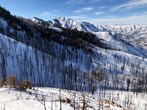
Peak 8281 is the high point of an infrequently visited mountain in the Wasatch Mountains of Utah, not too far east from the capital city of Salt Lake. This mountain is seen by hundreds of drivers daily travelling on Interstate 80 far below in Parleys Canyon. The mountain is wedged between Parleys Canyon (I-80 corridor) and its tributary Lambs Canyon. It is a mid-elevation mountain with some coniferous forest on its north slope; otherwise it has dense patches of scrub oak mixed with some maple and mountain mahogany, making it a bushwhack of a hike. I looked at it from Lambs Canyon before successfully trying the route recommended below. The high point is on a long more-or-less east/west trending ridge with bedrock outcrops. Expansive views are to the south, east and west; northerly views are partly obstructed by trees (especially mountain mahogany). The final section of ridge travel will show extensive fire damage. It is a good half-day or less hike by the route I recommend.
The Parleys Canyon Fire, August 2021
The Parleys Canyon Fire started at about 2PM on Saturday, 14 August 2021. It started adjacent to Interstate 80 - the ignition was officially attributed to hot particles emitted by a malfunctioning catalytic converter. The fire took off on a very hot dry day. Partial and total road closures of the interstate highway and other area roads followed. Area homes were evacuated. The huge plume of smoke was obvious from the Salt Lake valley.
A well-timed rainy period (especially with heavy rain on 18-19 August) greatly suppressed the fire. The fire was 90% contained by 21 August, and declared 100% contained the day after. 541 acres were burned. It was officially stated that the fire (spreading uphill and south/southeast from the ignition point) did not crest the mountain ridge, but clearly the large trees on the ridgeline were badly scorched (confirmed up-close on 11 January 2022).
Getting There
The most practical starting place is the town of Summit Park: one of the trailheads on Matterhorn Drive as listed on the account of Summit Park Peak. I paraphrase from the Summit Park Peak account: Take interstate 80 Exit 140 "Parleys Summit". Turn west onto Aspen Drive (the frontage road), passing the gas station. Take the first left - Parkview Drive. Stay on Parkview Drive as it meanders up and south through a residential district, taking care not to turn off this road for any reason. Parkview Drive will dead-end in a T - intersection with Matterhorn Drive. At this intersection is the trailhead with several parking spaces. Take care to park so as not to obstruct snow removal, or to not block residential traffic.
Route
Study the map before the hike - this description will make sense. Start up the signed trail toward Summit Park Peak. A network of municipal trails (foot and bike) is found here; your immediate goal is the west-east oriented ridgeline of which Summit Park Peak is the east end. The Salt Lake / Summit county border veers east from a hilltop, and following this boundary takes one to the top of Summit Park Peak. However, head west from this hilltop, to some point along this ridge where a broad saddle with some aspen forest is not far below to the northwest. The objective Peak 8281 will become visible when the forest thins. The route continues with descent to this broad saddle and re-climbs the next ridgeline to the north. This ridgeline can be followed to the west to reach the summit. I took ~1.5 hours from trailhead to summit and had time left over to visit Summit Park Peak as well.
Alternative route: park at the end of the Kilby Road (Summit Park, road parallels I-80). There is a trailhead with very limited parking. Walk down the road about a mile or so; the route is self-evident over the burn scar.
Red Tape
Trailhead parking is extremely limited; carpool if you can.
When to Climb
A few people have summited when there was little or no snow; I cannot vouch for their experience. It seems to me that a good snowpack will eliminate a lot of bush-whacking; I took ~1.5 hours from the Matterhorn Drive trailhead to reach the summit on snowshoes.This is not to say that it will not present difficulties: attaining the final summit ridge (steep and south-east facing) should be done on stable, well-consolidated snow.