
|
|
Area/Range |
|---|---|
|
|
33.81440°N / 116.6783°W |
|
|
Hiking, Mountaineering, Sport Climbing, Bouldering, Mixed, Scrambling, Canyoneering, Skiing |
|
|
Spring, Summer, Fall, Winter |
|
|
Overview
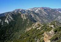
The Peninsular Ranges are a group of north-south running mountain ranges which stretch approximately 900 miles from southern California to the southern tip of the Baja peninsula. They are part of the North American Coast Ranges that run along the Pacific coast from Alaska to Mexico. They are bound by the Pacific Ocean on the west and the Sonoran Desert on the east in California. On the Baja Peninsula their eastern boundary is the Sea of Cortez/Gulf of California.Aerial View of the Peninsular Ranges in CA
The Peninsular Ranges include the Santa Ana Mountains, San Jacinto Mountains, and Laguna Mountains of southern California and the Sierra Juarez, Sierra San Pedro Mártir, and La Giganta mountains of Baja California. The vegetation in these mountains varies from coastal sage scrub to chaparral to oak woodland to conifer forest, depending on elevation.
View Larger Map
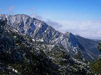
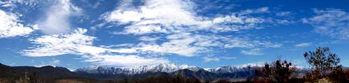
These mountains are notable for many reasons. The Santa Ana Mountains are the largest intact natural landscape remaining in coastal southern California. The San Jacinto Mountains rise up dramatically from the desert areas to the north and east and are a popular area to visit both in the winter and summer. Mt. San Jacinto has one of the highest vertical reliefs in the US; this peak soars 10,350 feet above Palm Springs. The Laguna Mountains are in eastern San Diego County and at their eastern edge is a sharp escarpment that drops down dramatically to the Sonoran Desert. The Sierra Juárez and the San Pedro Mártir contain the southernmost extremity of the Mediterranean climate. Also, in both of these ranges, 10 species of pines along with white fir, incense cedar, and many species of oak can be found growing. Picacho del Diablo at 3100 m (10,153 ft), the highest point on the peninsula of Baja California, is in the San Pedro Mártir Mountains. The La Giganta Mountains are the southernmost mountains on the Baja Peninsula and there are many notable cave paintings there.
There are endless peaks to climb and trails to explore in the Peninsular Ranges. To the left on this page are just some of the mountains and rocks that others here have climbed and written about!
North of the Peninsular ranges are the Transverse Ranges which run east-west.
Getting There
In southern California I-10 runs east-west along the northern boundary of the Peninsular Ranges. Major north-south Interstates are I-5 along the coast and I-15 and I-215 inland. Highways 74, 76, and 78 each head into the Peninsular Ranges with Hwy 79 linking them. A good map of southern California should show all these highways and the boundaries of the San Bernardino and Cleveland National Forests which roughly are the boundaries of the Peninsular Ranges.
In Mexico Hwy 1 is the main north-south route along the Sierra Juárez, the San Pedro Mártir, and the La Giganta Mountains.
The PCT runs through the Peninsular Ranges in Southern California. Click here for more info on trails in the Cleveland National Forest.
Suggested Map: Pacific Crest Trail 1 (Southern California) $10 Order it from the National Forest Store
Red Tape

An Adventure Pass is needed when recreating on the San Bernardino and Cleveland National Forests.
Click here for more info on wilderness permits for the San Bernardino National Forest.
Click here for more info on wilderness permits for the Cleveland National Forest
Click here for more info on wilderness permits for the Mount San Jacinto State Wilderness
Fire restrictions on the San Bernardino National Forest.
Campfire permits are required year-round in some areas. The permit is free and can be issued by any Forest Officer. Call your local ranger station for more info.
External Links
Geologic, climate, and vegetation overview of the Peninsular Ranges
Weather Forecast from the NWS
Cleveland National Forest
San Bernardino National Forest
Cuyamaca Rancho State Park
Palomar Mountain State Park
Mt. San Jacinto State Park
Santa Rosa & San Jacinto Mountains National Monument
San Pedro Mártir Mountains
Camping
Campgrounds on the San Bernardino National ForestCampgrounds on the Cleveland National Forest
Visitor Centers
Santa Rosa and San Jacinto Mountains National Monument Visitor CenterEcology of the Peninsular Ranges
From Wikipedia:Several terrestrial ecoregions cover portions of the Peninsular Ranges. Most of the ranges are in the Nearctic ecozone. On coast side of ranges, California chaparral and woodlands ecoregion covers the northern portion of the range, in southern California and northern Baja California. Baja California desert ecoregion runs along the coast side of the southern portion of the Peninsular Ranges. On eastern side of ranges, Sonoran Desert ecoregion covers southeastern California and northeastern Baja California as far south as the town of Loreto, Baja California Sur. Anza-Borrego Desert State Park, on the eastern side of the Peninsular Ranges in San Diego County, is famous for its springtime profusion of Sonoran Desert wildflowers. The Gulf of California xeric scrub ecoregion covering the southeastern portion of the peninsula and the islands of the Gulf of California.
The higher portions of the Peninsular Ranges, especially the west-facing slopes, are home to coniferous and mixed forests. Cleveland National Forest covers much of the southern California Peninsular Ranges, and includes oak woodlands and forests of Jeffrey Pine (Pinus jeffreyi) and Coulter Pine (P. coulteri). Sierra Juarez and San Pedro Martir pine-oak forests cover upper slopes of Sierra Juarez and San Pedro Martir ranges. These isolated forests, predominantly pines, White Fir, junipers and oaks, harbor many rare and endemic species.
The southern end of the Baja California Peninsula, including the Sierra de la Laguna, was formerly an island, and evolved in relative isolation from the northern part of the peninsula. It is considered part of the Neotropic ecozone, and its flora and fauna share many affinities with southern Mexico and Central America. It includes three distinct ecoregions, the Sierra de la Laguna dry forests, Sierra de la Laguna pine-oak forests, and San Lucan xeric scrub.
 Laguna Mountains