
|
|
Mountain/Rock |
|---|---|
|
|
33.64880°N / 116.5595°W |
|
|
Riverside |
|
|
Hiking |
|
|
Spring, Summer, Fall, Winter |
|
|
7054 ft / 2150 m |
|
|
Overview
The Desert Divide is a spur ridge that runs south from Red Tahquitz to Toro Peak on the San Jacinto Massif. Pine Mountain is one of the many noteworthy "bumps" along the Pacific Crest Trail on the Desert Divide with grand views of Garner Valley to the west and Coachella Valley to the east.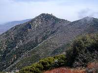
Pine Mountain may be a slight chore to ascend to due to the less-traveled "ducked" trail off the PCT, but it can be clearly seen and easily identified from Garner Valley by the large monolithic pinnacle and rock croppings on the summit. Its gentle sloping sides are spotted with boulders, thick Manzanita, Chaparral and occasional pines that produce monstrous cones. It was added to the Hundred Peak Section list in 1962.
The crowning prize of Pine Mountain's summit is the 60' granite monolithic pinnacle that sits on the southern end, and although the Sierra Club's HPS does not consider the monolith to be the true summit of Pine Mountain, it is the tallest feature on the plateau - go figure. To ascend the pinnacle, some 5th class climbing is required. The eastern prow is the obvious low-end, possibly 5.3, to the summit where two anchor bolts are found on the northern edge of the pinnacle. (No rings though; slings replaced on 08 April 07). Rappel from here.
The southern face will produce much more difficult routes considering it is mostly over-hanging. The northern face is wrought with lichen, may be interesting routes if cleaned up.
From Pine Mountain's summit, the most interesting views are north to east - Coachella Valley, Hell's Kitchen in Palm Canyon, and sprawling views of the Santa Rosa Mountains are most prominent. Southeast of Pine Mountains is Devil's Rockpile, a bit of an organpipe-like formation of fragmented blocks with a troublesome access issue due to thick Manzanita and steep slopes.
Getting There
From I-15, north or southbound, you can exit in Temecula onto Winchester Road (Hwy 79N) and head north to Hwy 74E and continue on through Hemet and up the slope on pleasant winding mountain roads, complete with competition "S-curves" to Mountain Center. Once you reach Mountain Center at the intersection of Hwy 243 to Idyllwild and Hwy 74 to Palm Springs, stay to your right and on the 74. In approx 8.5 miles, you will reach Morris Ranch Road on your left, a fire station sits on the corner. Turn left here.Or you may exit in Temecula onto Hwy 79S and drive east toward the San Jacinto Mountain range for approx 20 miles, then turn left onto Hwy 371 for Anza. In another approximate 20 miles up a long slow grade to about 4500' through dry rocky terrain, passing the Temecula Olive Oil Company ranch and Cahuilla Casino, you will reach Hwy 74 bound for Palm Springs to the east and Mountain Center to the northwest. Turn left at Hwy 74, there is a nice restaurant on the right hand corner, Paradise Cafe; probably the ONLY good place to eat for many, many miles. Approx 3 miles after turning left, you will come upon Morris Ranch Road on your right with a fire station on the corner, turn to the right here. You will pass a sign for the trailhead to Thomas Mountain on your left just prior to reaching Morris Ranch Road.
Once on Morris Ranch Road, drive approx 3.5 miles, passing the Joe Scherman Girl Scouts of America Camp and many mobile homes. On the right, you will come to a gate with a sign for "Cedar Springs Trail." Park in the vicinity and be sure to post your National Adventure Pass.
The Approach
From the gate at Cedar Springs Trail trailhead on Morris Ranch Rd, begin your 4-mile trek to Pine Mountain. You will have no choice but to stay on “The Trail” due to the barrage of “no trespassing” signs, wire fences and gauntlet of gates (there are 4 of them). There are even picnic tables and trash cans along the way.
At the third gate, you will finally be entering the National Forest boundary and feel you have escaped the confines of bureaucracy, but wait….one more gate…. The gentle switchback trail takes you to the PCT for another 1.5 miles; great view of the canyon and surrounding area along the way, but as this portion of the trail remains in the sun, take care to protect yourself from the heat and rays. The only running water can be found dribbling from a pipe in the clearing near the picnic tables.
At the saddle of PCT and Cedar Springs Trail junction, turn right and continue to march east, then south for approx another 1.5 miles, passing Little Desert and Pyramid Peak. If you’re interested, there will be a small pile cairn on your right for climbing trail to Pyramid Peak. Otherwise, continue on PCT just passed Pyramid Peak and into the saddle between Pyramid and Pine Mountain. There will be a “ducked” trail to your left the meanders up a knoll directly west of Pine, take this trail and keep a watchful eye out for each successive “duck,” there are many.
This half-mile climbers’ trail will mainly skirt Pine Mtn west to south; in some spots it is a bushwack but totally manageable even with a decent sized pack. Tall Manzanita and thick underbrush threaten and daunt the feint climber, but press on through. Don’t forget to enjoy the views, gar-hugo pine cones, and scrambles along the way. The trail will dump you on the western portion of the summit plateau; class 2 scrambling gets you to large rock cropping where geo-markers are located and more to the south will put you in position to climb the pinnacle. Those interested in climbing the pinnacle should rope up considering the consequences of uncontrolled slippage on lichen. Small pro is all that is needed in horizontal cracks, and 50m rope will be enough for the rappel. Check out the eastern prow for easier route up.