
|
|
Mountain/Rock |
|---|---|
|
|
32.94680°N / 116.6068°W |
|
|
6512 ft / 1985 m |
|
|
Overview
| Prominance: 2,854' | 2nd Highest Peak in San Diego County | ~6.2 miles round-trip | 1,610' elevation gain |
| Park fee/dogs allowed | Line Parent: Hot Springs Mountain | Quadrangle: Cuyamaca Peak | Located in the Cuyamaca Mountains |
The city of San Diego isn't particulary known for hiking or mountains. San Diego County however, has some decent hills located in the eastern reaches of the county. About 42 miles to the east on highway 8 are the Cuyamaca Mountains and the VERY popular, Cuyamaca Rancho State Park (Est: 1933). Within this state park is the counties second highest point, Cuyamaca Peak (pronounced- 'Kwee-a-meck-a').
This state park (24,700 acres) boasts over 100 miles of hiking trails, campgrounds, interpretive sites, equastrian opportunities and mountain biking. Also popular here is bird watching and wildlife viewing. The park really is a spetacular place as, within 40 miles of sea level, the terrain rises up a few thousand feet and provides cooler temperatures, different ecosystems and wilderness. And of course, recreation.
The Cuyamaca Mountains are part of what's called, The Peninsular Ranges of Southern California. The Peninsular Ranges are made up of several smaller ranges including: San Jacinto, Sierra de San Pedro Mártir, Santa Ana, Temescal, Cuyamaca and Sierra de Juárez to name but a few. All these ranges run from Southern California to the tip of Baja California.
This land was once inhabited by the Kumeyaay Native Americans who referred to the area as "Ekwiyamak" which roughly translates into, 'The place where it rains.' Which makes sense considering the higher peaks and points receive an average of 30" of rain per year.
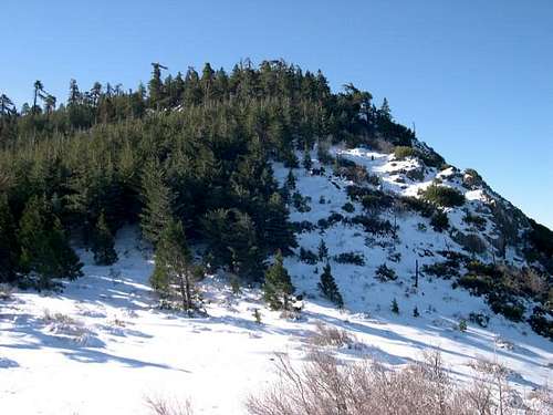
The Cuyamaca Mountains consist mainly of chaparrell, dispersed montane and pockets of pine forest with riparian ecosystems. There are year-round water sources and the San Dieago River can trace its hedwaters to these mountains.
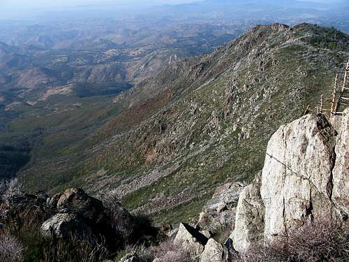
Cuyamaca Peak is the highest peak in the state park and the second highest in San Diego County. While hiking this peak, it may not seem much. But from a distance, its 2,854' of prominance stands out. From its gentle summit of which, there are multiple ways to access it, the views are among some of the best at the state park. To the Northeast is the Anza-Borrego Desert State Park (fairly good-sized in its own right) and to the west is the Cosmit Indian Reservation. All the aforementiond lies within Cleveland National Forest lands.
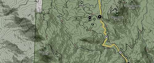
From the trailhead at Paso Picacho Campground, expect about 1,610' of elevation gain, so not too shabby. If you're looking for alternatives or something else in addition to Cuyamaca Peak, the state park has other trails and peaks such as: Stonewall Peak, Oakzanita Peak and Green Valley Falls Trail near the campground.
Some top trails in Cuyamaca Rancho State Park:
- Stonewall Peak Trail
- Deadhorse Falls Trail
- Cuyamaca Peak
- Middle Peak Loop Trail
- Oakzanita Peak Trail
- Sweetwater River Loop Trail
Getting There
From downtown San Diego, hop on highway 94 eastbound for roughly 7.7 miles.At the interchange for California 125 N, stay left (three lanes) and proceed onto 125 N. Highway 94 will turn south. Continue north for about 9.1 miles to the interchange with I-8 East. This is exit #18B, take it.
Drive east up into the mountains on I-8 for 24.1 miles. I-8 is also known as Kumeyaay Highway.
Take exit #40 (CA-79) north onto Japatul Valley Road towards the small town of Julian. After 7 miles, give or take, Cuyamaca Rancho State Park will be on the left. Park at the Paso Picacho Campground/trailhead. It is signed.
If the campground/trailhead is full (always a possibility with this location), just up the road is the Stonewall Peak trailhead. So this is also an option. Expect the drive to take 45 minutes to an hour.
Route Overview

This mountain is as easy as it gets. Cuyamaca and Stonewall Peak can both easily be done in a day. Start at the gate (trailhead) for Lookout Fire Road located next to park headquarters at Paso Picacho Campground. There IS another access point you can take that will shave off a short distance. Drive or walk through the campground to Camp Site #69. There is an outhouse located here too. There is a dirt path that will connect to the main, paved trail.
The route up Cuyamaca Peak stays on the Lookout Fire Road all the way to the summit. I'm not sure if the road actually gets used much these days, but its current state is fairly dilapitated and deteriorating. The average grade is about 12% and roughly 5.8 miles round trip. The campground is at 4,902'. The ascent to the top will get you about 1,610' of elevation gain. It is paved the whole way. So in the summer months, this walk will be hot. Plan on bringing extra water for yourself and your dog. This is the only hike/walk in the park that allows dogs. Expect it to take about 2.5 hours roundtrip. This is an easy to moderate walk.
On the lower sections of the road, the scars of the 2003 Cedar Fire are still prevalent. It's much hotter and more open. However, the higher one walks, pine trees start to populate the hillside providing much needed shade and views. On a clear day, from the summit, one can spy as far away as the Channel Islands and down into Mexico.
Red Tape/State Park Regulations

Day use visitors may use the picnic areas provided at the campgrounds for $10 per vehicle. The receipt is good for the entire park for the day. The picnic areas offer tables, restrooms, and barbeques. Visitors may also park in legal turnouts along the highway and hike for free. Fire is not allowed anywhere except in the developed picnic areas and campgrounds. The park is located approximately 50 miles east of San Diego on Highway 79. It is 15 miles south of the historical town of Julian.
For the most current information on the park, go to http://www.crspia.org. This website also covers our tremendous volunteer program and its opportunities. The park phone number is 760-765-3020. Come visit this park rich in beauty and history! The park phone number is 760-765-3020.Near the Beginning
Campsites are $30 per night. Reservations are necessary for weekends April through October. The camping fee includes one motorized vehicle. Extra vehicles are $10 per night. There is a limit of 8 persons per campsite. Dogs are allowed but are restricted to the campgrounds, picnic areas, and paved roads and Cuyamaca Peak Fire Road. They may not be left unattended.
Cuyamaca Rancho State Park number: (760) 765.0755 or (760) 765.3023
Current Fire Restrictions Info: (760) 767.4037
Park Hours: Basically dawn to dusk
RV's and trailers are allowed up to 30'- Dogs are allowed in campground areas and designated paved park roads.
Campgrounds are closed SEASONALLY. December through March.
Paso Picacho Campground: 760-765-3023
Green Valley Campground: 760-765-3024
Email the Park directly for further Information: cuyamaca@parks.ca.gov
Cuyamaca Rancho State Park
12551 Hwy. 79
Descanso, CA. 91916
OVERNIGHT FACILITIES
Environmental Campsites
Family Campsites
Group Campsites
RV Dump Station
Alternative Camping
RV Access
Environmental Campsites
Family Campsites
Group Campsites
RV Dump Station
Alternative Camping
RV Access
TRAIL USE
Hiking Trails
Horseback Riding
Hiking Trails
Horseback Riding
DAY-USE ACTIVITIES & FACILITIES
Historical/Cultural Site
Picnic Areas
Env. Learning/Visitor Center
Exhibits and Programs
Guided Tours
Interpretive Exhibits
Nature & Wildlife Viewing
Museums
Family Programs
Geocaching
Historical/Cultural Site
Picnic Areas
Env. Learning/Visitor Center
Exhibits and Programs
Guided Tours
Interpretive Exhibits
Nature & Wildlife Viewing
Museums
Family Programs
Geocaching
OTHER FACILITIES & VISITOR INFORMATION
Parking
Restrooms / Showers
Restrooms
Drinking Water Available
Parking
Restrooms / Showers
Restrooms
Drinking Water Available
When To Hike
Cuyamaca Peak is climable all year. Summer can get very hot and dry down here with high temps in the upper 90s to the low 100s. Spring and fall are great but my favorite time of year for Cuyamaca Peak is winter. Right after a winter storm Cuyamaca Peak can have a thick blanket of fresh snow, not uncommon to be thigh deep! And the views that time of year are crystal clear. It is awesome to be standing on Cuyamaca Peak after a winter storm in thigh deep snow looking west at the Pacific Ocean!! And then turning east and looking out at the desert.
Camping
Cuyamaca State Park has two main campgrounds: Paso Picacho and Green Valley. Both are very 'family orientated' and large. Both also run on a reservation system from April to September. Keep in mind, during the summer months, weekends especially, both campgrounds fill up fast. Otherwise, it is first come, first serve.
Piso Picacho- This campground sits t 5,000' and is located five miles to the north. There are 85 sites here and the two most popular trails in the park originate here. Lake Cuyamaca can also be accessed from here. Each campsite has a fire ring and picnic table. This campground has restrooms and pay showers but no hook-ups (for your RV). Firewood and ice can also be purchased. Each site is $30/night and during busy summer weekends, reservations are HIGHLY ENCOURAGED.
Dogs are allowed as long as they stay in the campground, picnic areas or Cuyamaca Peak Fire Road. Each reservation allows for one vehicle. Anything additional is $10 extra.
Reservations can be made through: ReserveCalifornia at #1.800.444.7275 (PARK)
Green Valley- This campground has 81 camping sites and sits lower at 4,000'. What sets this area apart from Picacho is that there is a stream that runs through the center of the area. It's the first camping area accessed off I-8. Otherwise, it has all the same amenities, regulations as referenced above.
Reservations can be made through: ReserveCalifornia at #1.800.444.7275 (PARK)
The Cedar Fire
On October 25th, 2003 a lost hunter lit a signal fire in hopes of being found. That fire quickly burned out of control and went on to become one of California's biggest wildfires in state history, The Cedar Fire. The fire, having burned 280,278 acres took just over two weeks to be contained. It burned 90% of Cuyamaca Rancho's 24,700 acres.
This is the reason when one is visiting the state park, there is a clear lack of trees or forest. The slow rate of natural forest regeneration has prompted forest officials to step in and artifically speed up the reforestation. This is being done through state grants and private donations. Wildfires of course, are still a threat. So PLEASE be mindful of park regulations and restrictions.
History
 Early History of the Cuyamaca

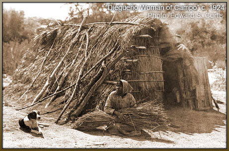
The ancestors of today's Kumeyaay Indians occupied the Cuyamaca Mountains from antiquity into the historic period. Their village sites are located throughout Cuyamaca Rancho State Park. Some of these sites are: Ah-ha' Kwe-ah-mac' [what the rain left behind], Iguai' [The Nest], Wa-Ku-Pin' [Warm House], Mitaragui' [Crooked Land], Pilcha' [Basket Bush] and Guatay' [Big House].
Historic mention of the Cuyamaca Kumeyaay begins in 1782 when Spanish Lt. Col. Pedro Fages noted that the villagers "approached me very pleasantly and I gave them some beds." However, the Kumeyaay did not want to give up their independence. They resisted missionization. In 1837, a Mexican expedition attacked the villagers of Ah-ha' Kwe-ah-mac' after the Kumeyaay raided two ranchs to the south, eventually exacting a promise from the Kumeyaay to leave the settlers alone.
Augustin Olvera of Los Angeles obtained the Rancho Cuyamaca grant in 1845. Olvera intended to harvest timber but his contractor, Ceserio Walker 'being afraid of the Indians,' who kind of made a revolution, abandoned the place.
By 1857, a few Kumeyaay remained. James Lassator reportedly bought about 160 acres in Green Valley from the last heredity chief in the region. Lassator's family maintained a home, hay fields and a way station there supplying those still using the area's early overland trails until after his death in 1865.
Gold Mining in the Cuyamaca
The 1869 discovery of gold near today's town of Julian triggered a brief but very frenzied rush to the Cuyamaca Mountains. The southernmost and most profitable of the mines was the Stonewall, located south of the Laguna Cuyamaca. By 1872, this profitable hard-rock mine supported a permanent worker's camp and mill. In 1886, mining entrepreneur and soon-to-be California Covernor, Robert W. Waterman purchased and expanded Stonewall's operqtions. At its peak from 1886 to 1891, the mine produced over 7,000 pounds of gold while regularly employing 200 men and housing their families at the company town, Cuyamaca City. Financial problems ensued after Waterman's death and by 1892, the mining had basically ended.
Later owners separated remaining gold from previously milled ore tailings using cyanide leaching until final closure in 1906. After the miners left, Cuyamaca City continued for several more years as a mountain resort.
Becoming a State Park
Capitalist Ralph M. Dyar bought the rancho in 1923 along with partners planning a resort development for the lakefront's northern half. Dyar also built his family a second home in Green Valley using locally sourced stone from the mine. Later, when all had passed or moved on, this second home was used as park headquarters and as a visitor center until the disasterous 2003 Cedar Fire which burned iot down.
The Great Depression ended Dyar's development plans. In 1933, he sold it to the state of California to be included in their new state park system. Cuyamaca Rancho State Park was doubly benefitted in the 1930's by the placement of two CCC labor camps which helped to develop the park and install infrastructure (many of the current campgrounds & trails).
YouTube
Topographic Map
External Links
- Laguna/Cuyamaca HPS roundup - Dec 27, 2005
- Wildflower guide (brochure)
- Modern Hiker (California)
- Hiking Project
- I Hike San Diego
- Curtrent Weather!
Additions and CorrectionsPost an Addition or Correction
Table of Contents
Bob Burd - Jan 21, 2004 11:26 pm - Voted 10/10
Untitled CommentAre missing. These can be added using the "Edit" form, adding these coords for the peak:
32.9468 / -116.6068
thanks,
bob
caleb - Feb 8, 2006 2:46 pm - Hasn't voted
Untitled CommentIf you don't want to pay the 6$ for parking at the campsite, you can drive north up 79 about another 5 miles to the parking area by Lake Cuyamaca. Parking is free until 8 pm.
Cross 79 and walk up Milk Ranch Road (Fire Road) to Azalea Springs Fire Road, follow Azalea Springs up to Conejos Trail which will lead you to the summit of Cuyamaca Peak. This trail is about 3.5 miles altogther.
Personally I like it better than walking the paved trail from the campsite. It's a little more secluded and quiet... Injoy...
NavySeabee - May 1, 2006 10:51 pm - Voted 10/10
Campground usage feesThe fees to use / park at Paso Picacho campground are now $6.
tarol - Mar 13, 2007 11:49 pm - Voted 10/10
Mountain loin?What exactly is a mountain loin? lol Otherwise it's a great page :)
NavySeabee - Sep 6, 2011 12:07 pm - Voted 10/10
Fees up againThe day use fees are now $8. Happy times!