
|
|
Mountain/Rock |
|---|---|
|
|
33.65280°N / 116.5716°W |
|
|
Riverside |
|
|
Hiking |
|
|
Spring, Summer, Fall, Winter |
|
|
7035 ft / 2144 m |
|
|
ANOTHER Pyramid?
 Yes, another Pyramid Peak.
The views along this section of the PCT are breathtaking; the entire Santa Rosa range to the south, the San Jacinto Wilderness to the north, the Coachella Valley to the east, and Garner Valley, Thomas Mountain along with Lake Hemet to the west all seen quite clearly year-round. Many of the Hundred Peaks Section peaks in the 7000’ range are found here and easily accessed off the PCT.
Although the name “Pyramid Peak” first appears on USFS San Bernardino National Forest map in 1959, the USGS bench mark on the summit reads “Morris.” Undoubtedly “Pyramid” is a popular peak name in California; there are numerous other peaks, rocks and hills so described, mostly for their shape. Pyramid Peak was added to the HPS Peak List in 1965.
Getting There
From I-15, north or southbound, you can exit in Temecula onto Winchester Road (Hwy 79N) and head north to Hwy 74E and continue on through Hemet and up the slope on pleasant winding mountain roads, complete with competition "S-curves" to Mountain Center. Once you reach Mountain Center at the intersection of Hwy 243 to Idyllwild and Hwy 74 to Palm Springs, stay to your right and on the 74. In approx 8.5 miles, you will reach Morris Ranch Road on your left, a fire station sits on the corner. Turn left here. Cedar Springs trailhead.
Or you may exit in Temecula onto Hwy 79S and drive east toward the San Jacinto Mountain range for approx 20 miles, then turn left onto Hwy 371 for Anza. In another approximate 20 miles up a long slow grade to about 4500' through dry rocky terrain, passing the Temecula Olive Oil Company ranch and Cahuilla Casino, you will reach Hwy 74 bound for Palm Springs to the east and Mountain Center to the northwest. Turn left at Hwy 74, there is a nice restaurant on the right hand corner, Paradise Cafe; probably the ONLY good place to eat for many, many miles. Approx 3 miles after turning left, you will come upon Morris Ranch Road on your right with a fire station on the corner, turn to the right here. You will pass a sign for the trailhead to Thomas Mountain on your left prior to reaching Morris Ranch Road.
Once on Morris Ranch Road, drive approx 3.5 miles, passing the Joe Scherman Girl Scouts of America Camp and many mobile homes. On the right, you will come to a gate with a sign for "Cedar Springs Trail." Park in the vicinity and be sure to post your National Adventure Pass.
Elevation is approx 4900' so icy road conditions may exist in winter.
The Hike In
From the gate at Cedar Springs Trail trailhead on Morris Ranch Rd, begin your 3.5-mile trek to Pyramid Peak. You will have no choice but to stay on “The Trail” due to the barrage of “No Trespassing” signs, wire fences and gauntlet of gates (there are 4 of them to keep range cattle out of National Forest). There are even picnic tables and trash cans along the way.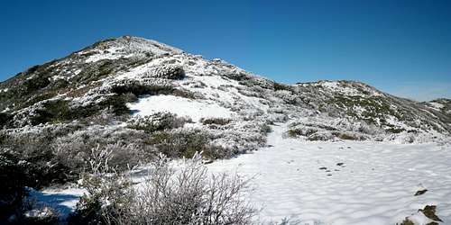 Looking at ascent via southeastern shoulder.
For the first 3/4 mile, the trail alternates between trail and road. At the third gate, you will finally be entering the National Forest boundary and feel you have escaped the confines of bureaucracy, but wait…one more gate. The gentle switchback trail takes you to the PCT for another 1.5 miles; great views of the canyon and surrounding area along the way, but as this portion of the trail remains in the sun during spring and summer, take care to protect yourself from the heat and rays. The only running water can be found dribbling from a pipe in the clearing near the picnic tables.
At the saddle of PCT and Cedar Springs Trail junction, there is a large half-busted sign pointing to several different trails, turn right for the PCT and continue to march east and soon headed south, passing Little Desert for about a mile.
Pyramid Peak is easy to spot once you are on the Desert Divide. There will be a small pile cairn on your right for climbing trail to Pyramid Peak’s summit once you have hiked just past the peak’s southeastern shoulder. A light use game trail is also available about a quarter mile before this point which switchbacks through thicker brush up the northeastern face. I prefer this route for the descent, especially with snow; and apparently so do the deer, rabbits and large cats.
The established ascent trail switchbacks gingerly through shrubs, low trees and eventually boulders. It is possible to make this a Class 2 endeavor by scrambling up the southern face and you’ll also avoid most of the brush. Keeping large summit boulder in sight, navigation is simple.
Admin Stuff
 Yikes!
Be mindful of private property and courteous parking at the trailhead. There is not much parking space available at this trailhead, especially when roads are iced when abundant snow.
Mountain Weather
Compliments of NOAA. The forecast.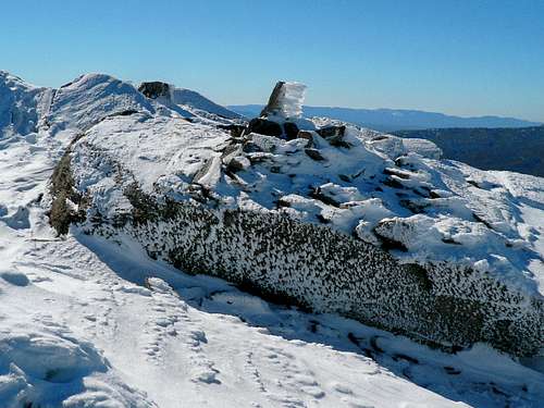 As of 12 December!