
|
|
Mountain/Rock |
|---|---|
|
|
38.78983°N / 120.2417°W |
|
|
Trad Climbing, Sport Climbing, Toprope, Bouldering, Aid Climbing, Scrambling |
|
|
6000 ft / 1829 m |
|
|
Overview
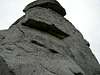
Phantom Spires is a rock climbing area west of south Lake Tahoe consisting of granitic rock formations, or spires, among low scrub and old burned pines.Various sport and trad routes have been established, mostly single-pitch, though some might be more convenient to do in two pitches. Some of the routes have walk-offs, but others require rappelling. Compared to Lovers Leap, it's less crowded, warmer and windier, with shorter routes.
I have included only a small sampling of the climbs available - a far better guide is South Lake Tahoe Climbing : SuperTopos, Chris McNamara, SuperTopo, 2004.
Here is a list of the various formations and the climbing that can be found on them : (as listed in the guide above)
| Name | Climbing Grades (YDS) |
|---|---|
| Upper Spire | 5.6 - 5.11d |
| Middle Spire | 5.5 - 5.11b |
| Lower Spire | 5.5R - 5.11d |
| Lizard Head | A3, 5.10c - 5.11d |
| Lost John | 5.8 - 5.12a |
| Shark's Tooth | 5.8 - 5.10a |
| Clam Rock | 5.10d - 5.12? |
| Twin Owls | 5.8 - 5.11a |
| Gorilla Rock | 5.6 - 5.8 |
| Phantom Wall (right) | 5.7 - 5.12a |
 |  |  |
Getting There
From the west :1. Drive 4.9 miles on SR50 from Kyburz and make a left onto Wrights Lake Road.
2. Follow this paved winding road uphill for about 2.2 miles, then take a left turn onto an unpaved logging road.
3. Continue for about a half mile to the parking area.
From the east : go 4.1 miles on SR50 from Strawberry / Lovers Leap to Wrights Lake Road and make a right, then follow the directions above.
Note: The unpaved access road may be a bit rough, with large rocks, ruts, and scraping brush. Supposedly, low-clearance vehicles may have problems during the winter or spring, but it's possible to park at pullouts on the road and walk the rest of the way in. I've made it in with an ordinary passenger car in dry weather.
Red Tape
No day-use fees or permits are required.When To Climb
I've only climbed here in the fall so far, but winter and spring are supposed to also be nice, if there is a good stretch of weather. The recommendations I have read are that summer is too hot.This area faces south, so it's warmer, but relatively unsheltered and so may be quite windy.