|
|
Mountain/Rock |
|---|---|
|
|
32.97872°S / 69.40613°W |
|
|
Mountaineering |
|
|
14107 ft / 4300 m |
|
|
Overview
This mountain is located in Cordon del Plata, a very popular climbing region near Mendoza city. Most of the people visitng the region goes to climb the highest mountains as Plata o Vallecitos. The access to Pico Parra is through a different valley, much less crowded than the one used to access Plata or Vallecitos.So the large chance is that no other people will be in the area. In adition view from the summit is fantastic. The mountain is surrounded by other mountains, so from any direction the view is magnific.
From the summit is possible to see Loma Blanca, Estudiante, Caucaso, Iluso, Ignorado, Rastrillo, Falso Santa Elena, Santa Elena, Agustin Alvarez, Morro Chato, Juncion, Cerro Colorado and Mausy making it probably one of the nicest views in all Cordon del Plata.
Climbing is not difficult at all but is long. Access is through the red morraine, the valley with the ski trails.
A good suggestion is to camp up in the morraine. There are many peaks that can be climbed from there. Also some ice cascades depending on the time of the year.
 |
Getting There
You must start climbing at Vallecitos Ski Center. It's located 80 km from Mendoza. Access is via the international route, getting out at Potrerillos. From there to Vallecitos are 23 km. There is a ski center with many shelters and a couple of hostels to stay.From the ski center (32 58.484S 69 21.506W) you need to go up through the red morraine (NW of the ski center). This is the valley where the ski trails and the lifts are. You will need to go up through the base of the mountain. There are aproximatley 5 or 6 km walking in the morraine to gain 1000 mts. of height.
At this point (32 56.466S 69 23.596W) the morraine splits in three and you need to turn left.
 |
Red Tape
No permits required. You can register in the ski center and also, mules are avilable if you wan't to camp up and don't wan't to carry all your stuff.When To Climb
November to March is the most popular time, but it can be climbed all year long. |
Camping
There are some shelters in the ski center. It's also possible to camp up in the morraine. Some people uses to go up to the small valley from where Pico Parra is easily accesed.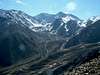 |
Area map
As a compliment to previous information I'm adding this map of Cordon del Plata area. Main ridges are marked in black. Main peaks with a flag. In blue there is a river that goes through Campo Grande and Las Veguitas. And main routes are also marked in colors. This map covers mostly of the area, but not all. The area of Nevero peak at S of Plata is not included. And some peaks ( Blanco, Salto) at N of Agustin Alvares and Santa Helena are also not showed. |
Corax - Jan 15, 2006 3:50 pm - Hasn't voted
Untitled CommentI have the new map of Cordon del Plata in front of me. It's based on SRTM-3 Final and the altitude of Pico Parra is given at 4387m.