
|
|
Mountain/Rock |
|---|---|
|
|
39.99340°N / 112.06557°W |
|
|
Utah |
|
|
Hiking |
|
|
Spring, Summer, Fall, Winter |
|
|
7720 ft / 2353 m |
|
|

Overview
This isn't one of the big boys of the Wasatch mountains found to the east nor does it qualify as a western Utah desert peak as it just on what might be considered the border of that desert so it is a peak that is sitting on the fence. So what does this peak offer? Read on.
This one offers a nice short hike on a seldom visited peak less than 80 miles from Salt Lake City, Pinyon Peak is not far from the mining town of Eureka and an easy drive from the booming suburbia of Utah Valley. Pinyon is easily noticed from Provo since it has a distinctive pyramidal shape but most of us look right at it and don't know the name of it. Until recently, I couldn't have named it either nor any of the other peaks that are seen to the west of Utah Lake but when I found out that it had over 1000 feet of prominence (1229 to be exact), I put it on my "to do" list. It ranks as #225 on the Utah 1,000 feet and above prominence list and that was good enough for me since chasing any peak with more than a thousand feet of prominence is worthy of my attention since I need something to keep me motivated, especially in the wintry months of the year. A fellow peakbagger who is into chasing prominence had been there a week or two before me so it does see a few of
us. There is no trail and you can climb it from most any direction although the Southwest ridge is the best way to ascend the peak.
While the peaks to the east of I-15 get a heavy load of snow during snowstorms, peaks like Pinyon Peak often get just a small load of snow and this makes it possible to hike without snowshoes for a good part of the winter. Pinyon is probably hikeable most of the months of the year but it is the kind of peak that will allow you to have a good workout and is one you can squeeze in as either a morning or afternoon hike. The value of a hike like this one is that it introduces you to an area you probably wouldn't have hiked or climbed in before since there is so much good stuff so close to Salt Lake City and Utah County. SP member Eric Willhite has done an outstanding job in compiling a list of peaks in these areas here. Check his effort out when you get a chance.
One negative about the summit of Pinyon Peak is that it is wooded and doesn't offer great views from the summit area. In fact, the best views are found on the flanks of the peak as you ascend it or down a bit to the east of the summit. A pile of rocks and a stick marked the summit when I found it and I placed a register amidst the rocks for others to sign. I found no benchmark but then there was a fair amount of snow marking the top area and it is possible if one exists it was buried.
The peak was named after the dominant species of tree that is found on the flanks of it, the Pinyon pine. In the great basin, this tree can generally be found at elevations varying from 4500 feet to 7500 feet. (Link)

Getting There
 SW ridges is on the right of pic
If you are coming from Salt Lake City or Provo, take I-15 south to the Santaquin exit 244. Go east on U.S. 6 and follow the signs to Eureka, about 21 miles from the exit. After going through the twisty curves near the top of the pass a couple miles from Eureka, watch for a turn off (unmarked) that heads to Homansville Pass. It is the first dirt road to the right as you come out of the canyon part of U.S. 6. See the pic and map for a bit of clarification on finding this road. From US 6 to the pass, it is not more than one mile on a dirt road. Turn north off the highway and the road bends back a bit to the east before heading uphill to the north. The first thing you will see is a gate with a No Trespassing sign but just left of this gate the road goes over a cattle grate and this is the road you want. Follow it as it drops down a bit and then goes uphill where it will lead up to a saddle, Homansville pass. At the pass, you will note a rough dirt track heading off uphill to the right. Unless you have high clearance 4WD, it is just as well to park at the pass and hoof it from there. Just to the left side of the road at the pass is an area where you could probably car camp.
Route - Southwest Ridge

If you hike from the pass by following the 4WD road (I didn't drive it because it was muddy and still had snow patches and I need all the exercise I could get from this hike), you will crest out atop a small hillock and the road will then drop down a bit so you'll lose maybe 150 feet in elevation before you actually get onto the flank of the southwest ridge. As there is no trail, just pick a line upwards and eventually you'll meet up with a fence that runs up the ridge. Stay on the west side of the fence and the way is fairly simple.
After the fence ends, the route turns into a class 2 type of hike and the key is just to stay on the rocky ridge and follow it up. There is no other way to go so just keep gaining elevation and enjoy the views when you get openings.
After you leave the rock of the ridgeline, the top rounds out and before long you'll most likely find the cairn with the stick that marks the top of Pinyon Peak. A register in a glass container is to be found among the rocks. It is marked Badger but ignore that and sign in.
Round trip: 2.4 miles
Elevation gain (including the loss from the pass) 1500 feet.
 As seen from nearby Boulter Pk
Red Tape
None that I am aware of. It isn't posted as no trespassing and I believe it is on BLM land.Main Office
2370 S. 2300 W.
Salt Lake City UT 84119
Phone: 801-977-4300
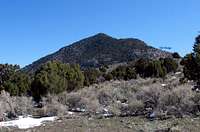
 As seen from the Provo area
Camping
Since this is a simple day hike, camping is probably not part of most people's plans. However, there is a camping spot (primitive) at the pass area where you could car camp. Motels and a Koa are available in Provo.
Weather - Eureka

Google Map for PInyon Peak
View Larger Map
Eureka Utah & History
WikipediaGhost Town
History of Eureka
Pictures of Eureka
Map of area
Eureka Mining Museum
Nearby peaks & Tintic Range info
Boulter PeakSabie Mountain 8021' (east & visited on 4-6-09)
East Tintic North Group
Eric Willhite has put together an outstanding resource which I recommend to anyone interested in Pinyon Peak as it gives you a great feel for the overall area. Click on "East Tintic North Group" For more great stuff, go to his home page, I think you will be impressed by what he is putting together. Eric, by the way is a SP member so take a moment and check his stuff out. [img:503531:alignleft:medium:]