
|
|
Mountain/Rock |
|---|---|
|
|
45.38495°N / 6.92001°E |
|
|
Vanoise |
|
|
Hiking, Mountaineering, Skiing |
|
|
Spring, Summer, Fall, Winter |
|
|
11273 ft / 3436 m |
|
|
Overview
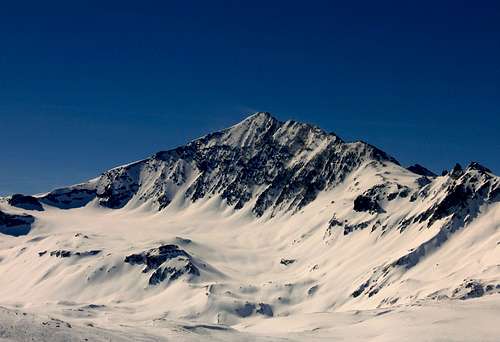
 Pointe de la Sana North-West Face
 |
In the National Parc La Vanoise in France lays this impressive pyramid-shaped mountain: Pointe de La Sana. The mountain has a fabulous look and can be seen from the slopes of the ski-area’s of Tignes and Val D’Isere.
The mountain is mostly climbed during the summer months. In winter it can be climbed as a ski-ascent. From the summit the view is beautiful. You have a stunning view of La grande Motte and La Grande Casse, the highest peak in the Vanoise range. You can also see Mont Pourri, Dome de la Sache, La grande Sassiere and even Gran Paradiso in the distance. Last but not least the view towards Mont Blanc is really awesome.
Underneath the summit lays the ‘le Glacier des Barmes de l'Ours’ which has to be crossed in order to reach the summit. Pointe de la Sana is often climbed in combination with its neighbour Mean Martin. (3330m)
Getting There
La Sana 3436m
Val D’isere:
Motorway A43 to Albertville
Dual carriageway to Moutiers
Road D902 to Bourg St Maurice and Val d'Isère
Please note that in autumn & winter the following alpine passes are closed :
- Petit St Bernard
- Iseran
- Mont Cenis
You can also take the train to Bourg-St Maurice. Once in Bourg St Maurice, you can easily take a bus or taxi to Val d'Isère.
Bourg St Maurice train station to Val d'Isère : 40mn by car & 1h10mn by coach
Termignon:
Autoroute A43 to Chambéry : exit Modane
(at 15 km of Termignon)
• N6 : direction Haute-Maurienne/Lanslebourg
• Lyon : 2h • Marseille : 4h • Paris : 6h
Getting to the Top
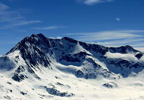
La Sana South Face
The route starts at the village of Val D’Isere. From there you follow the road to Le Manchet, where a restaurant is located together with a couple of houses. From there the real ascent starts. There are two options at this point:
Route 1: You follow the road towards col de la Rocheure (2917m) from there you walk over the mountain ridge until Col Barmes de l’Ours at an altitude of 3077m. The final stage is up to the summit, which is fairly steep (>30 degrees slope).
Route 2: You follow the road to the Barmes de l’Ours glacier, which you have to cross completely. Eventually you’ll reach Col Barmes de l’Ours. The last part to the summit is the same as route 1.
In winter the mountain can climbed on skies. (only for experienced skiers!) all the way down to the village of Val d”isere. In summer the descent is mostly done via Refuge de la Femma, where you can get a drink, and stay the night when maybe planning an ascent to Mean Martin the next day.
From Col de la Rocheure (2917m) it’s a 2 hour walk down to Refuge de la Femma. Marked trails go down from Refuge de la Femma to the village of Val d’Isere, ending point of the route.
Of course the ascent to Pointe de la Sana can also be done from Refuge de la Femma ( Femma-Col de la Rocheure – Pointe de la Sana)
Note that crampons and rope are needed to cross the ‘des Barmes de l'Ours’ glacier!
Check out the Map (below) for a visualisation of the routes!
Orientation: SE
Difficulty: PD
Difficulty Ski: S2/S3
Time: 7 hours
Map: IGN: Top25 3633ET (Tignes-Val d’Isere)
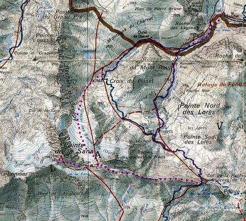
Map Pointe de la Sana
Red Tape
Rules of the National Vanoise Park :-No picking, no collecting the animals, plants, rocks and fossils all belong to the environment.
-No loud noise, no disturbance, for the tranquility of all.
-No dogs, not even on a lead, so as not to disturb wild and domestic animals alike.
-Leave no rubbish, no trace of your passage.
-No camping, no bivouacking. Bivouacking is allowed near certain refuges, under the control of the warden.
-No fires. To reduce the risk of wild-fires and to avoid damaging the soil.
-No paragliders or other means of air-transport. Overflying at less than 1000m is also forbidden for the tranquility of the animals.
-No mountain biking. For the safety of walkers and to avoid erosion of the paths. However, certain trails in the Park have been designated for biking.
Huts
Refuge de la FemmaHight: 2352 m
Location: Termignon area
Places: 44
Telephone: 04 79 05 21 27
Guardian: Mme C. Jacquemot - 23, rue du Coin - 73500 Aussois - Tél./Fax : 04 79 20 33 00