
|
|
Mountain/Rock |
|---|---|
|
|
45.33284°N / 7.10223°E |
|
|
Alpi Graie |
|
|
Mountaineering |
|
|
Summer |
|
|
11900 ft / 3627 m |
|
|
Overview
 Albaron di Savoia
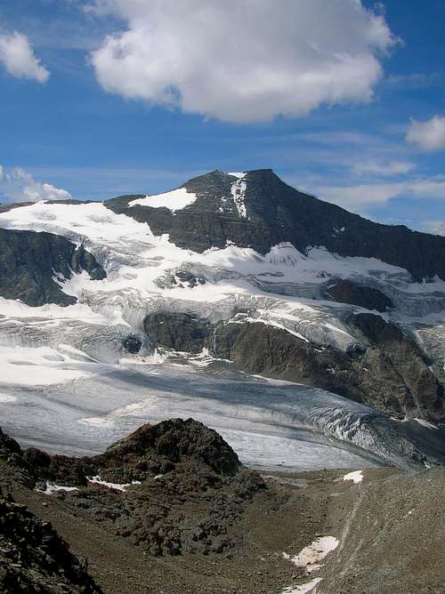
Albaron di Savoia or Pointe d'Albaron is an elegant mountain, expecially wiew of SE or NO sides where it appears like a sharp snowy pyramid.
For its easy and amusing routes it is visit frequently from a lot of alpinist and is very important even for ski-mountaineering.
Wiew from Refuge des Evettes, Albaron forms with Piccola Ciamarella and Glacier des Evettes a big glacial basin with impressive seracs and glacial tongue like highest mountain areas.

SE ridge

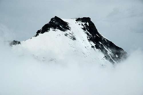
Albaron north side. 1984...
Getting There
- Italy:From Turin motorway A55 exit Venaria Reale follow indications for Lanzo Torinese and go on through Germagnano and Ceres, here you enter in Val d'Ala, continue passing Ala di Stura and Balme and reach Pian della Mussa (1830 m.) where the road ends (78 km from Turin). From here in 2.30 h on a good path you can reach the Rifugio Gastaldi.
 Albaron - East side
- France:
From Modane motorway A43 exit Le Freney follow indications for Val Cenis, Bessans, Bonneval sur Arc and Col de l'Iseran.
- Just after Bessans turn right towards Les Vicendieres and Averole. Reach the parking just before Les Vicendieres (1880 m., 45 km from Modane), only allowed person could go on with the car. From here in 1.30 h on the road or 1.10 h on a good path you can reach the Refuge d'Avérole.
- Reach Bonneval sur Arc, pass the old village and just after the first left bend turn right towards L?Ecot (2027 m., 52 km from Modane). From here in 1.30 h on a good path you can reach the Refuge des Evettes (2.30 h from Bonneval sur Arc).
Red Tape
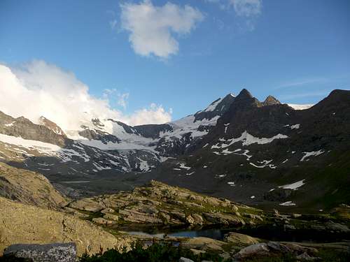 Albaron di Savoia view from Ref des Evettes
 ITALY
Pay parking at Pian della Mussa, at the start of the route to Rifugio Gastaldi, there are no limitations for climbing and hiking. No problem for one night free camping, take care of nature as usual!
FRANCE
Park at Les Vicendières, at the start of the route to Refuge d'Avérole, and at L'Ecot, at the start of the route to Refuge des Evettes, are free and there are no limitations for climbing and hiking. Free camping is forbidden, the whole region is part of the Parc National de la Vanoise you should take care of nature as usual limitations of natural parks.
When To Climb
The best time is from June or July (depending of snow quantity and conditions) to September.First Ascents
O versant: R.C. Nichols and J.V. Favret - Sept 2, 1866SE ridge: G. Yeld, J. Heelis, A. Paiot and B. Le Greffier - Aug 8, 1878
NO versant: J. Mathieu, C. Regaud, B. Le Greffier and JM. Blanc - Jul 17, 1895
S wall : E.C. Biressi, O. and G. Dumontel - Aug 17, 1903
NE wall : E. Garrone, A. Sacerdote, P. and P. Castagneri - Sept 4, 1905
NNO ridge : V. Paschetta and J.B. Culet - Aug 27, 1929
NNO pilier : C. Guinard - Aug 13, 1968
Accomodations
ITALYYou can find accommodations in all villages of Valli di Lanzo, at Pian della Mussa you can use Rifugio Città di Ciriè .
Contacts: Rifugio Città di Ciriè phone +39 0123 820008
You can use Rifugio Gastaldi as base for the ascents to: Uja di Ciamarella (3676 m), Albaron di Savoia (3627 m), Bessanese (3604 m), Piccola Ciamarella (3540 m), Punta Chalanson (3466 m), Punta Maria (3302 m.).
Contacts: Rifugio Gastaldi phone +39 0123 565008 or visit www.rifugiogastaldi.it
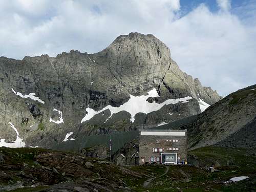
GASTALDI hut
FRANCE
You can find accommodations in all villages of Haute Maurienne- Vallée de l'Arc, at Bonneval sur Arc you can use Chalet CAF de Bonneval sur Arc .
Contacts: Pizzeria La Benna phone +33 04 79 05 83 78
You can use Refuge d'Avérole as base for the ascents to: Albaron di Savoia (3627 m), Bessanese (3604 m), Punta d'Arnas (3560 m), Punta Maria (3302 m.).
Contacts: Refuge d'Avérole phone +33 04 79 05 96 70, Club Alpin Français de Lyon phone +33 04 78 42 09 17
You can use Refuge des Evettes as base for the ascents to: Albaron di Savoia (3627 m), Piccola Ciamarella (3540 m), Punta francesetti (3410 m), Punta Tonini ( 3324m).
Contacts: Refuge des Evettes phone +33 04 79 05 96 64, Club Alpin Français de Lyon phone +33 04 78 42 09 17
google books - Guida dei Monti d'Italia - Alpi Graie Meridionali
MAPS
- IGC- Istituto Geografico Centrale
N° 103, 1:25.000
Rocciamelone Uja Di Ciamarella Le Levanne
- ASF- Alpi senza frontiere / Alps without frontiers (IGN Institute Geographique National)
N° 13, 1:25.000
Mont-Cenis Ciamarella
- IGC- Istituto Geografico Centrale
N° 2, 1:50.000
Valli di Lanzo e Moncenisio
Contacts: Pizzeria La Benna phone +33 04 79 05 83 78
You can use Refuge d'Avérole as base for the ascents to: Albaron di Savoia (3627 m), Bessanese (3604 m), Punta d'Arnas (3560 m), Punta Maria (3302 m.).
Contacts: Refuge d'Avérole phone +33 04 79 05 96 70, Club Alpin Français de Lyon phone +33 04 78 42 09 17
You can use Refuge des Evettes as base for the ascents to: Albaron di Savoia (3627 m), Piccola Ciamarella (3540 m), Punta francesetti (3410 m), Punta Tonini ( 3324m).
Contacts: Refuge des Evettes phone +33 04 79 05 96 64, Club Alpin Français de Lyon phone +33 04 78 42 09 17
Books and Maps
- G. Berruto, L. Fornelli "Guida dei Monti d'Italia - Alpi Graie Meridionali" Club Alpino Italiano/Touring Club Italiano (1980). (Italian)google books - Guida dei Monti d'Italia - Alpi Graie Meridionali
MAPS
- IGC- Istituto Geografico Centrale
N° 103, 1:25.000
Rocciamelone Uja Di Ciamarella Le Levanne
- ASF- Alpi senza frontiere / Alps without frontiers (IGN Institute Geographique National)
N° 13, 1:25.000
Mont-Cenis Ciamarella
- IGC- Istituto Geografico Centrale
N° 2, 1:50.000
Valli di Lanzo e Moncenisio
Mountain Conditions
You can get whether forecast at this site:www.3bmeteo.com
www.nimbus.it
www.regione.piemonte.it official site of the Regione Piemonte
www.meteofrance.fr
www.nimbus.it
www.regione.piemonte.it official site of the Regione Piemonte
www.meteofrance.fr