
-
 23162 Hits
-
 83.69% Score
-
 17 Votes
|
|
Mountain/Rock |
|---|---|
|
|
45.54960°N / 6.82660°E |
|
|
12398 ft / 3779 m |
|
|
Overview
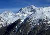
The Mont Pourri is the second highest peak of the Massif de la Vanoise after the Grande Casse. It's the most northern situated summit of this massive face on the Col du Petit Saint Bernard. This huge mount dominates Bourg Saint Maurice, located at 12 km distance from nearly 3000 meters. The NE face is breathtakingly high located over the haute Tarentaire : the village of La Gurraz, 4 km as the crow flies from the summit is 2500m lower and threatened by the 2 hanging glaciers of La Gurraz north and south which drop down to near 2000 m height (they are the lowest permanent icefields in La Vanoise). Mont Pourri means rotted mountain.
 |  |  |  |  |
Getting There
Start point is Peisey-Nancroix near Bourg Saint-Maurice.
Nearest airports :
-Geneva Cointrin (150 km),
-Chambery (100 km),
-Lyon (180 km).
By the road, A 43 to Albertville. Take then the route de Tarentaise to Moutiers (27 km from Albertville), Aime. Bellentre (22 km after Moutiers). At the right the D 87 leads to Peisey-Nancroix (it belongs to the famous ski-resort of Les Arcs). Continue after Peisey along the D87, cross Le Moulin, Nancroix, to Les Lanches (park near the bridge 1524m).
Some advices : saturdays in february and march arrive to Albertville before 8 h or after 16 h. Traffic infos on France Bleu Pays de Savoie (103.9 )
 |  |
Red Tape
There is no permit required to climb this mountain, but the massif is located in the Park National de la Vanoise.
Rules :
-No picking, no collecting the animals, plants, rocks and fossils all belong to the environment.
-No loud noise, no disturbance, for the tranquility of all.
-No dogs, not even on a lead, so as not to disturb wild and domestic animals alike.
-Leave no rubbish, no trace of your passage.
-No camping, no bivouacking. Bivouacking is allowed near certain refuges, under the control of the warden.
-No fires. To reduce the risk of wild-fires and to avoid damaging the soil.
-No paragliders or other means of air-transport. Overflying at less than 1000m is also forbidden for the tranquility of the animals.
-No mountain biking. For the safety of walkers and to avoid erosion of the paths. However, certain trails in the Park have been designated for biking.
Histoy of the Park
King Victor Emmanuel II created the Gran Paradiso royal reserve in 1856; it was enlarged in 1922 and made into a national park. In France, the creation of a national reserve in the Vanoise mountains was being considered from 1943, under pressure from the Club Alpin Français, the Touring Club de France and hunting associations. There were numerous hesitations concerning the surface area to be protected as well as whether the focus should be placed on humans or animals. Finally, the project was planned with two zones, one central, the other peripheral. The ibex was at last permanently protected by the Vanoise National Park, created on 6 July 1963 - the first French national park. It has a common border with the Italian Gran Paradiso National Park. Twinned since 1972, together they cover 1250km2 and constitute the largest protected site in Western Europe.
When To Climb
This mountain can be climbed all year round. Also quite a popular extreme skiing mountain in the spring time.
Normal Route
The normal route of ascent is by the crevassed and fairly steep Glacier du Geay from the Refuge du Mont Pourri.
Orientation : NW
Total level : 1425m
Maximal level : 40°
Difficulty : PD
-Day 1 : Climb to the Refuge du Mont Pourri (850 m level, 2h). From les Lanches, cross the bridge and take the path to the hamlet Beaupraz. Climb tight to near 2000m, crossing the Combe du Trovet (gully) and reach the Chalets des Loyes. Take left, climb to the Plan des Ecuries to the refuge (2370m)
-Day 2 : Take the path near the waterstream to the annex of the refuge (2460m). Climb along the moraine (steep and painful) to the rightbank of the glacier (at 2880 m). Go the glacier up in the middle, avoiding the seracs. Climb the last NW slope to the shoulder and follow the ridge to the summit.
Descent : the same way
Equipment : crampons, ice axe, harness.
 |  |  |  |  |
Huts
Refuge du Mont Pourri (2370m) Tél 04 79 07 90 43
 |
Other summits of the Mont Pourri Massive
- Mont Turia (3650m) : noth ridge of the Mont Pourri
- Dôme de la Sache (3601m) : second highest peak in the south of the Mont Pourri. A gigantic icecap covers the summit.
- Grande Parei (3365m)
- Dôme des Platières (3473m)
- Aiguille du Saint Esprit (3419m) : elegant needle on the left of the Glacier du Geay and dominating the normal route
- Aiguille Rouge (3227m) : can be reached by cablecar from Arcs 2000.
- Rochers Rouges (3002m)
- Pointe du Chardonnay (2870m) : gully skiing eldorado in the skiresort of Tignes
- Aiguille Percée (2778m) : crumbly limestone massif, eroded by the high winds that bluster through the Palet and Sachette passes chiselling weird and wonderful geological structures – needles, turrets and other sculptures forged by Mother Nature.
 |  |  |  |  |
Climbing History
-The first ascent was accomplished solo by the famous Chamonix guide Michel Croz the 3/10/1861.
-Second ascent : W. Mathews and Rev T. G. Bonney in august 1862 with Michel and Jean Croz.
-Third ascent : Horace Walker with Melchior Anderegg and J. Jaun (26/06/1868)
-Fourth ascent : Joseph Paccard from Peisey (1873)
-First crossing Dôme de la Sache - Mont Pourri : J. Blanc-le-Greffier and V. Mangard (13/08/1880)
-SE face : A. Messimy with J. Blanc-le-Greffier (26/08/1894)
-E ridge : M. H. Mettrier wjth Jean-Marie and Auguste Blanc (30/07/1904)
-South face with skis : 1000 m Pierre Tardivel le 26 mars 1989
-Direct south face with skis : 850 m Pierre Tardivel le 12 avril 1995.