
-
 8178 Hits
-
 87.76% Score
-
 25 Votes
|
|
Mountain/Rock |
|---|---|
|
|
46.51486°N / 11.73714°E |
|
|
Trad Climbing |
|
|
Summer |
|
|
9688 ft / 2953 m |
|
|
Overview
Geographical classification: Eastern Alps > Dolomites > Sassolungo Group > Pollice del Sassolungo
Pollice del Sassolungo - Langkofel Daumen 2953 m
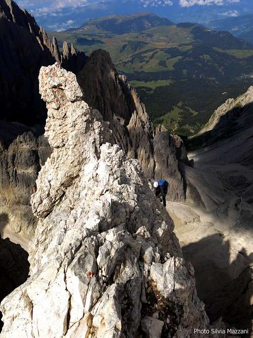
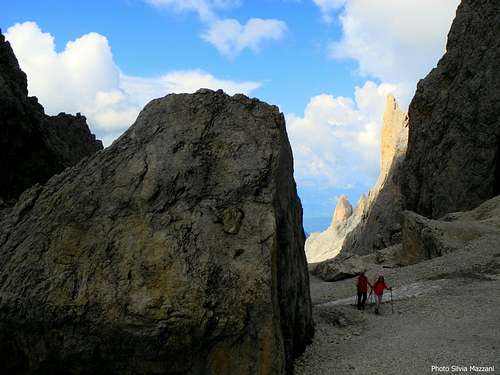
Pollice del Sassolungo – or Langkofel Daumen in German – is a slender and sharp obelisk located in the Sassolungo Group and separated from the nearby Punta delle Cinque Dita or Fünffingerspitze (Five Fingers Peak) by the narrow notch named Forcella del Pollice 2891 m. Despite being very close to the structure of Punta delle Cinque Dita, the needle rises isolated overhanging the Forcella Sassolungo, towards which it projects a steep wall 250 meters high, North-East oriented.

This wall is bounded on the right by an exposed and sharp edge facing North, along which it runs an elegant route of moderate difficulty, one of the most classic climb of the Sassolungo and of the whole Dolomites. The route is very well known and visited for the beauty of its breathtaking line and for the excellent quality of the rock. Known as the Spigolo Nord del Pollice or Daumenkante (Thumb North Edge) it faithfully follows the edge with a spectacular and amusing rock climbing on very carved “dolomia”.
History
The first ascent to the top was made in the year 1899, August 7th by the Austrians Otto Ampferer and Karl Berger, the same who first summited Campanile Basso di Brenta.
Getting There
The starting point to climb Pollice del Sassolungo is Rifugio Passo Sella, where it starts the trail to Forcella Sassolungo. Here is located the lower station of the Forcella Sassolungo cable-car, reaching Rifugio Demetz on Forcella Sassoungo m. 2681.
Road access
- From Bolzano North follow the road to the little town of Ponte Gardena. From here take the road entering Val Gardena, pass Ortisei and reach Selva di Val Gardena. After 5,2 km from Selva di Val Gardena the road forks; turn to right (signpost Passo Sella), reaching the Rifugio Passo Sella
- From Trento follow the Brennero Motorway towards North, exit Egna-Ora and take the road S51 towards Fassa Valley, getting to Cavalese, Predazzo, Moena and Canazei. Here take the road to Passo Sella, reaching the pass and descent some hundred meters to the Val Gardena side, reaching the Rifugio Passo Sella
- From Brennero Pass take the Brennero Motorway towards South, exit Chiusa and then follow the roadway joining the Val Gardena road, pass Ortisei and Selva di Val Gardena. After 5,2 km from Selva di Val Gardena the road forks; take the road on the right (signpost Passo Sella), reaching the Rifugio Passo Sella
Red Tape
There are no special restrictions or prohibitions in hiking and climbing


Spigolo del Pollice - Daumenkante

Spigolo Nord del Pollice - Daumenkante (Thumb North Edge)
Summit altitude: m 2953
Difficulty: Alpine AD+, UIAA max IV-
Route length: 350 m
Exposure: North
First ascent: Gustav Jahn, Karl Huter and Erwin Merlet 1917, july 22nd
Starting point: Rifugio Demetz on Forcella Sassolungo
This route is one of the most classic and repeated climbing of the Sassolungo Group. The excellent quality of the rock, the exposition of the route and the beauty of the tiny summit make this itinerary absolutely advisable.
Approach: from Rif.Demetz head to right to the base of the rocks of the obvious Pollice (a few minutes from the shelter)
L1 - Climb the wall with black stripes - often wet - and reach a gravel ramp to its left end. III +, 30 m.
L2 - Follow the ramp towards right and then for gravel, easy rocks and a little gully reach a narrow saddle between the first pinnacle and the edge itself. I, II 120 m.
L3 - Follow the ridge to reach a stance below a vertical section along the edge. II, III, 35 m.

L4 – Up a vertical section along the edge with superb climb and reach a terrace IV-, 30 m.
L5 – Traverse left and descent an easy chimney to reach a small saddle with boulders under a vertical jump, from which climb a crack, reaching a huge hourglass. II, III, 30 m.
L6 - To the right climb the edge again to a little terrace III+, 30 m.
L7 – More easily along the ridge reach a step. III-, 30 m.
L8 - Overcome the vertical edge slightly to the right with fun and exposed rock climbing to the terrace. III+, IV- 30 m.
L9 – Up again on the sharp edge to reach the airy summit III, IV-, 30 m.


Descent: From the top an easy 10 m. downclimb in the SW direction (towards Punta delle Cinque Dita) leads to the first abseils’anchor. Three abseils (each one 25 meters long) lead to the deep notch named Forcella del Pollice m. 2891, joining the Pollice Normal route. Downclimb a few meters along the gully below the notch to a terrace. Cross the gully and traverse right to a slabs. Downclimb along the slabs (cairns), then head to NW reaching the Piano Inclinato over the Rif. Demetz. Near a cairn is located the first abseils'anchor. Four abseils (15 m + 20 m. + 25 m. + 25 mt) lead to the bottom of the wall.
Other routes on Pollice del Sassolungo


- SW face Normal route – UIAA IV, 60 meters – It’s the route of the first summiters, nowadays rarely climbed
- North East Face, Via Nike max UIAA V+, 250 m. – Stefano Righetti and Ivan Fuligni 1997 – This route runs on the left and very close to the classic Spigolo del Pollice, reaching this latter in the upper part
- North East Face, Diretta del Pollice max UIAA VI, 250 m. – Karl Runggaldier and Toni Malsiner 1959 – The route climbs straightly the North-East face of the tower. Rarely climbed.
- East Face, Via Senoner max VI and A1, 150 m. – Mario Senoner and Karl Runggaldier 1963 – Short challenging climb, rarely repeated
When to Climb
Best season goes from the end of June to the end of September. The face - North oriented - is sometimes cold even in summertime.
Where to stay
Plenty of accomodation's possibilities both in Val Gardena and Val di Fassa. Near Passo Sella there are some huts.
Rifugio Demetz at Forcella Sassolungo
Meteo
Meteo Bolzano Alto Adige
Meteo Alto Adige
Guidebooks and maps


-Guidebooks

“IV grado Dolomiti Occidentali by Emiliano Zorzi, Ed. Idea Montagna
“Sassolungo” by Ivo Rabanser - Collana Guide dei Monti d’Italia, CAI TCI
- Maps
Tabacco 05 Val Gardena 1:25.000 Tabacco 06 Val di Fassa 1:25.000