-
 48064 Hits
-
 93.06% Score
-
 41 Votes
|
|
Area/Range |
|---|---|
|
|
46.51750°N / 11.72910°E |
|
|
10437 ft / 3181 m |
|
|
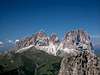
Overview
The Langkofel / Sassolungo Group is one of the most significant mountain groups of the Dolomites. The 6 main summits of the group (Langkofel/Sassolungo, Fünffingerspitze/Punta d. Cinque Dita, Grohmannspitze/Punta Grohmann, Innerkofler Turm/Torre Innerkofler, Zahnkofel/Il Dente and Plattkofel/Sassopiatto) are arranged in the shape of a horse-shoe opened to NW. All mountains are very close together, they form an impressive landscape with huge faces, bizarre rock formations, exposed ridges and some minor snow or ice fields/gullys above green meadows. The borders of the group are Val di Fassa (South), Grödnertal/Val Gardena (north) and the Sellajoch/Passo Sella (East). West of the group there are Schlern and Seiser Alm, Europe's largest mountain pasture.Especially the view from the Sellajoch to the trio of Langkofel, Fünffingerspitze and Grohmannspitze or the view to the huge N and NE-faces of Langkofel are among the most impressive landscapes of the whole Dolomites or even the world. Just imagine that Langkofel's summit is located nearly 2000m above the village of St. Christina in Gröden / Val Gardena. Hiking below the huge wall results in craned necks...
All the mountains of the group have huge faces with many climbing routes. For all of them - with the exception of Plattkofel - you need mountaineering experience. There are only a few regularly done routes: the famous traverse of Fünffingerspitze, the regular route of Fünffingerspitze, the regular route and the Via Ferrata ("Oskar Schuster Steig") to Plattkofel and the regular route to Langkofel. Most other routes are rarely climbed and as a result most of the summits are not crowded.
Beside climbing the Langkofel Group is a paradise for hiking. Possibly the best hike is the hike around the whole group from Sellajoch and back (very long). Other good possibilities are the ascent of Plattkofel using the regular route from Fassajoch or a hike along the Friedrich-August trail at the Fassa-side of the group. Also a visit to the Langkofelkar (ascending from St. Christina / Mt. Pana or descending from Langkofelscharte) is recommended.
  |
The Names:
The Saslonch Group is located on "Ladinian territory" - the heart of the Dolomites around the Sella Group where this old rhaetian language is spoken. However, as I have found out while posting the Vallaccia (Italian) / Valacia (Ladinian) Group there are different pronounciations and spellings depending on the area. All guidebooks are in Italian or German anyway so that the LAdinian names are hard to come by. I used both Italian and German names as I found them, sometimes I translated the German names into Italian, never the Italian names into German. It might be a little confusing but over time the missing names will be added to the listings.
|


Geology
 Schematic Map of the Saslonch Group
The Langkofel / Sassolungo Group is a perfect example to discuss the origin and geology of the Dolomites. Its base is a large porphyry plate, the so-called Bozen / Bolzano plate, which covers all the area of the western Dolomites and reaches far north towards the Alpine main Ridge. At the southern borders of the Dolomites you can witness these formations in the Lagorai Group where the build-up of the Alps left a long chain of porphyry mountains. In the Dolomites themselves you will see these structures everywhere the open faces reach deep enough.
Some 350 - 400 million years ago a shallow inland sea - the so-called Thetis Sea - started to cover the area in which you find the Dolomites today. This coverage lasted for about 200 million years. Huge coral reefs formed the remainders of which today are the mountain groups of the Dolomites. Inside pressure converted the original limestone into the harder and more durable dolomite but when the sea retreated the dolomite formations were covered and interspersed between sandstone sediments. These latter eroded much more easily creating the impressive formations you witness today.
The Langkofel Group is one example for a former atoll reef, just like the equally impressive but much smaller Vallaccia Group a bit further south. Both Groups still show the circular form and both have collapsed on one side and over the ages were eroded by a small creek. Still the closeness you witness when at the centre of the group is absolutely comparable.
|


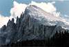
Saslonch / Langkofel / Sassolungo
Saslonch / Langkofel / SassolungoLangkofel / Sassolungo is a huge wilderness of rock with big faces, a small glacier, pinnacles, ice gullies and big ledges. The regular route is a long, sustained route covering an elevation difference of 800 m. Famous for profiled climbers is the traverse using one of the big NE-face routes (Pichl-route etc.) for the ascent and the regular route for descent.
Langkofel is not a single mountain but rather is a massif with a width of 3000m and faces of 1000m height. The main summit is connected by a long ridge to Langkofeck / Spallone di Sassolungo, the eastern end of the massif. We are talking about the biggest single mountain of the Dolomites, even topping such big mountains as Civetta or Marmolada. The north face is counted among the 20 largest faces of the Alps and again compares with the Marmolada south face and the Civetta north-west face. The vertical distance from the summit to the village of St. Christina measures almost 2000m.
There are a multitude of satellite summits all around the Langkofel Massif. Many of them are interesting climbing destinations by themselves. The named ones shall be listed below:
- Nordwestschulter / Spalla Nord-Ovest (2811m)
- Nordturm / Campanile Nord (3130m)
- Pichlwarte / Pilastro Nord (2834m)
- Ostturm / Campanile Est (3120m)
- Roter Turm / Torre Rossa (3160m)
- Biwakturm / Torre del Bivacco (3150m)
- Apokalypsenturm (3158m)
- Pilastro Paolina
- Mittelturm / Campanile di Mezzo (3136m)
- Doppelturm / Campanile Doppio (3029m)
- Salami / Campanile Salame (2844m)
- Torre di Guardia (2633m)
- Bergführernadel / Guglia delle Guide (2787m)
- Wesselyturm / Gran Campanile del Sassolungo (3077m)
- Pyramidenturm / Torre Piramide (3100m)
- Unterer Pyramidenturm / Torre Bassa (2950m)
- Venusnadel / Campanile di Venere (2987m)
- Punta Rosemarie
- Punta Gialla (2700m)
- Langkofeleck / Spallone del Sassolungo (3069m)
- Ostturm / Torre Est (2850m)
- Dreieckiger Turm (2850m)
- Viereckiger Turm (2950m)
- Langkofelturm (2996m)
- Guglia Cristina
- Ostturm / Torre Est (2850m)
|


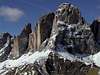
Pizes di Cin Dëic/ Fünffingerspitze / Punta delle Cinque Dita
Fünffingerspitze/Punta d. Cinque DitaThe "hand" of Fünffingerspitze / Punta delle Cinque Dita is one of the best known mountains of the Group as it can be easily seen from both Passo Sella and Passo Pordoi, two of the main (and crowded) road passes of the Area. Located between Langkofeleck / Spallone del Sassolungo and Grohmannspitze / Punta Grohmann it is one of the most popular climbing destinations of the group. The proximity to Langkofelscharte with Rifugio Demetz, which can be reached by a cableway from Passo Sella, ensures crowds at the bases of the many high quality climbs. The most recommendable route is the traverse of the mountain, climbing each of the five fingers.
Satellites:
- Dito di Dio (2825m)
- Daumen / Pollice (2953m)
- Zeigefinger / L'Indice (2980m)
- Mittelfinger / Medio (2996m)
- Ringfinger / Anulare (2953m)
- Kleiner Finger / Mignolo (2943m)
- Punta Leone (2934m)
|


Piza Grohmann / Grohmannspitze / Punta Grohmann
Grohmannspitze/Punta GrohmannGrohmannspitze / Punta Grohmann dominates the upper Fassa-valley. It is a massive block of dolomite separated from the neighbouring summits by deep passes. There are some very good, recommendable routes all of which are long, sustained adventures. Also the regular route used as common descent is not an easy climb (up to UIAA 4). As a result of this the Grohmannspitze is climbed rarely.
Satellites:
- Torre Zero
- Südturm / Torre Sud (3000m)
- Erster Turm
- Zweiter Turm
- Dritter Turm
- Vierter Turm
|


Langkofelkarspitze / Punta Dantersass
Langkofelkarspitze/DantersassLangkofelkarspitze is a secondary mountain in the centre of the group and is climbed very seldom. The mountain is notorious for its brittle rock. Because of the rock quality there are no recommendable routes though the views from the top must be spectacular with all the higher summits of the group close by and all around.
|


Ciampanil Innerkofler / Innerkofler Turm / Torre Innerkofler
Innerkofler Turm/Torre InnerkoflerThis is the second of the big mountains of the Fassa (southern) side of the Langkofel/Sassolungo Group. Similar to Grohmannspitze the mountain is climbed very seldom. There are some very good but demanding / very demanding routes. Even the regular route is not easy with a dangerous ice gully (crampons/ice axe often needed).
Satellites:
- Nordostgipfel (3060m)
- Torre Dagmar (3050m)
- Torre Astrid (3000m)
- Torre Fantasia (3000m)
|


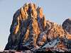
L Dënt / Zahnkofel / Il Dente
Zahnkofel/Il DenteThe third big mountain on the Fassa side of the Langkofel Group is a large spire, formed like a shark's tooth. It is climbed very seldom though there are some good and interesting routes. The normal route is a good, moderately difficult route of UIAA grade III. There are some very interesting but very seldom done routes at the north side of this mountain (a place for real adventures).
|


Sasplat / Plattkofel / Sassopiatto
Plattkofel/SassopiattoPlattkofel / Sassopiatto similar to its brother Langkofel / Sassolungo is a massive mountain with a long stretched ridge. However, it also is a mountain of contrasts. To the south-west you find a 30° slope, on its north-east side there is a labyrinth-like maze of towerlets and pinnacles. Many of the latter have established climbs but due to their remoteness they are rarely done.
Plattkofel is the only summit of the Langkofel / Sassolungo Group with an easy ascent route, the regular one using the SW-slope. It is a harmless hike on a good trail. On fine summer days you'll see the hikers lining up like ants to reach the central summit. On its SE-flank the famous, very beautiful and therefore popular Via Ferrata "Oskar Schuster Steig" climbs up to the summit adding to the crowds up there.
Satellites
- Kleiner Plattkofelturm / Torre Minore (2533m)
- Erster Plattkofelturm / Prima Torre di Sassopiatto (2691m)
- Zweiter Plattkofelturm (2718m)
- Dritter Plattkofelturm (2853m)
- Castiglioniturm
- Vinatzerturm
- Nordwandnadel (2800m)
- Westschulter (2700m)
|


Climbing Spots
Col Rodella : A beautiful crag above Campitello close to the upper station of the cable car from Campitelloto Col Rodella (access: 5 minutes from the cable). Bolted routes from 5 to 7b (5.9 to 5.12b)
Steinerne Stadt / Città dei Sassi : Bolted routes in a beautiful setting close to Sellajoch / Passo Sella at big boulders witch are somewhat tricky to find for the first time. Routes from 5 to 7c+ (5.9 to 5.13b)
Sasso delle Streghe : Close to Campitello in Val di Fassa, 12 bolted routes from 6b to 7b (5.11a to 5.12b)
Getting There
There are different villages below the Langkofel / Sassolungo Group: Ortisei / St. Ulrich, St. Christina and Selva di Gardena / Wolkenstein in Grödnertal / Val Gardena, Canazei and Campitello in Val di Fassa. Traveling to the Langkofel / Sassolungo Group most times means travelling to one of those villages. Grödnertal / Val Gardena and Val di Fassa are connected by the Sellajoch / Passo Sella. The common approch to the Langkofel / Sassolungo Group is done from Sellajoch / Passo Sella, which can be accessed by car or by public transportation from both sides.Approach from S
- From the south (Lago di Garda, Trento, ...) take motorway A22.
- Leave it at Auer / Ora and follow SS48 through Val di Fassa to Campitello or Canazei.
Approach from N
- From the north (Germany, Austria, ...) take motorway A22 from Brenner / Brennero.
- Leave the motorway at Chiusa / Val Gardena and follow the road through Grödnertal / Val Gardena to St. Christina and Wolkenstein / Selva.
Approach from W
- From the west (Switzerland, Bodensee, ... ) take the road to Reschenpass / Passo Resia and travel SS38 through Vinschgau / Val Venosta to Meran / Merano and Bozen / Bolzano.
- Turn off onto SS241 east across Karerpass / Passo di Costalunga into Val di Fassa.
- At Vigo di Fassa take SS48 north to Canazei.
- Alternatively take the Brenner motorway A22 north from Bozen / Bolzano until you reach Klausen / Chiusa.
- Here turn off into Grödnertal / Val Gardena.
Approach from E
- From the east (Cortina d'Ampezzo, Sexten Dolomites, ... ) follow SS48 via Passo di Falzarego to Arabba.
- From Belluno (coming from Venezia or Friuli) you can reach Passo Pordoi using the Canale d'Agordo Valley until you reach Alleghe.
- A bit further north the road from Falzarego joins and leads you to Passo Pordoi.
- Cross the pass and turn onto SS242 to Sellajoch / Passo Sella.
Red Tape
There is no red tape in the Langkofel Group. Bear in mind, however, that this is one of the most crowded areas in the Dolomites (or even the whole Alps). A large number of trails, especially to the south and west of the group, have been worn down considerably. In wet conditions this means slipping and sliding through the mud. Please stay on the trails at all times.When To Climb
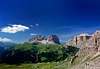
 Saslonch Group from Col Rodella
The climbing and hiking season runs from late May (hiking only) through late September. Given the steep north faces you'll find snowfields all through the year no matter what date.
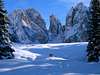
In winter the group is surrounded by downhill ski courses but venturing into the inner part of the horseshoe is rarely done. There are, however, beautiful cross-country paths to the south and on Seiser Alm / Alpe di Siusi.
Accommodation
The best information on boarding houses and hotels can be found on www.dolomiti.it. The site is not complete – you might find more information on local tourist web sites, but it already offers an impressive list. The following listing gives you an overview for the larger towns and villages surrounding the Marmolada Group.Val di Fassa
Grödner Tal / Val Gardena
- www.valgardena.it
www.groeden.info
- St. Ulrich / Ortisei
- St. Christina / Santa Christina
- Wolkenstein / Selva di Val Gardena
Camping
All around the group you can find a number of campgrounds:Val di Fassa:
- Marmolada
via Pareda
Canazei
Tel.: +39 0462.601660
Fax: +39 0462.601722 - Catinaccio
via Avisio 15
Pozza di Fassa
Tel.: +39 0462.763305
Fax: +39 0462.763501 - Soal
via Dolomiti 32
Pera di Fassa
Tel.: +39 0462.764519
Fax: +39 0462.764609 - Vidor
Località Vidor
Pozza di Fassa
Tel.: +39 0462.763247
Fax: +39 0462.764780
Gadertal / Alta Badia
- Camping Colfosco Corvara
Str. Sorega, 15
39033 Colfosco (BZ)
Tel. +39 0471 836 515
Fax +39 0471 830 801
info@campingcolfosco.org
Mountain Huts and Refuges
Sellajoch/Passo Sella:All of these huts are very easy accessible from the Sellajoch/Passo Sella.
Sellajochhaus, a mountain hotel with a long tradition close to the cable-car to Langkofelscharte. Good trailhead for all routes of the Langkofel Group.
Albergo Alpino Maria Flora, right at Sellajoch / Passo Sella, crowded, crowded, crowded ...
Rifugio Valentini, a famous climbers hut, good trailhead for the Langkofel Group close to Sellajoch / Passo Sella
Rifugio Salei, close to Rifugio Valentini
Langkofel-group:
Langkofelhütte / Rifugio Vicenza, CAI Vicenza, at the center of Langkofelkar, trailhead for the S-side of Langkofel and Plattkofel.
Demetzhütte / Rifugio Toni Demetz, at Langkofelscharte (chair lift), trailhead for the S-side of Langkofel and Fünffingerspitze.
Rifugio Comici, below the NE-face of Langkofel, no overnight stay.
Friedrich-August Hütte, beside the Friedrich-August trail from Sellajoch. Good trailhead for Grohmannspitze, Innerkofler Turm and Zahnkofel
Rifugo Sandro Pertini, nice, little hut below Zahnkofel
Zallingerhütte, below Plattkofel, possible trailhead for Plattkofel
Plattkofelhütte, at Fassajoch / Giogo di Fassa, possible trailhead for Plattkofel
|


Weather Conditions
Weather conditions Dolomites:www.dolomitimeteo.comWeather and avalanche conditions in Trentino: www.meteotrentino.it
Weather conditions South Tyrol / Alto Adige:www.meteoalpin.com
In addition most of the links posted in the "accommodation section also have weather info and/or webcams.
Maps & Books
Books:There is one very recommendable book, Sella - Langkofel Extrem, which the original submitter kletterwebbi used to help put up this page (I took hints from it as well). It gives an overview over hundreds of climbing routes in the area. One third of the book deals with the Langkofel Group.
- Climbing
- Sella - Langkofel Extrem
Richard Goedecke
Alpenvereinsführer
Rother Verlag
ISBN: 3-7633-1315-X
- Val di Fassa - Guida alle arrampicate sportive
Renato Bernard/Gabriele Bonnano
Dora' Publisher, Bolzano
- Sella e Sassolungo
Luca Visentini
Ed. Athesia, Bolzano/Bozen. (both in Italian and German languages)
- Classic Dolomite Climbs: 102 High Quality Rock-Climbs Between the Uiaa Grades III and VII (also available on CD)
Anette Kohler, Norbert Memmel
Mountaineers Books
ISBN: 0 8988 6693 6
- Sella - Langkofel Extrem
- Vie Ferrate
- Klettersteige Dolomiten
H. Höfler, P. Werner
Rother Verlag
ISBN: 3 7633 3096 8
- Hülslers Klettersteigführer
E.E.Hülsler
Bruckmann Verlag
ISBN: 3 7654 4161 9
- Klettersteige Dolomiten
- Hiking and Trecking
- Höhenwege in den Dolomiten
H. Dumler
Bruckmann Verlag
ISBN: 3 7654 3860 X
- Dolomiten
P. Fleischmann
Kompass Verlag
ISBN: 3 8705 1409 4
- Dolomiten 1 - Grödnertal
F. Hauleitner
Rother Verlag
ISBN: 3-7633-4248-6
- Dolomiten 4 - Fassatal
F. Hauleitner
Rother Verlag
ISBN: 3-7633-4061-0
Maps:
I have been using the maps by Kompass Verlag. There are two which differ in scale:- Val di Fassa, Marmolada, Gruppo di Sella
Kompass Map WK 686
ISBN: 3 8549 1768 6
Scale: 1:25000
- Sellagruppe / Gruppo di Sella
Kompass Map WK 59
ISBN: 3 8549 1066 5
Scale: 1:50000
- Val Gardena & Alpe di Siusi
Tabacco Map 05
In Memory of Stefan "kletterwebbi" Weber
![]() A note from the SP staff
A note from the SP staff
Stefan Weber, the member we all used to know from his climbing pseudonym kletterwebbi, died on May 28th 2004 in southern France at the age of 37.
Stefan joined SP early on in 2002 and contributed a number of excellent pages and routes to this site. He was an accomplished climber excelling in difficult alpine and technical routes. The Dolomites, especially the area around Gröden / Val Gardena were special to him, as it was his old ancestral home.
kletterwebbi was always willing to share his knowledge and experience with other climbers, mainly here on SP, but also on other sites. He contributed his IT expertise as webmaster of his local section of the German Alpine Club, where he also engaged in leading trips for fellow members. Besides his climbing and mountaineering activities he was a musician, a composer of contemporary music. Stefan will be greatly missed by us all.
This page will be kept in honor of kletterwebbi, one of SP's most talented, knowledgeable members, and without a doubt, one of our greatest fellow mountaineers.
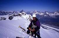
The picture was taken on the summit ridge of Lyskamm.
- Höhenwege in den Dolomiten