Getting my feet wet: Attempt number one
November 25, 2008. Asserting just a hint of my yen to be a maverick, I wished my usual hiking group well and drove to Provo, the idea being to top out on yet one more Wasatch 11,000er. I would drive to the Rock Canyon CG and hike up to the summit. Only 3,700' of elevation gain; about 6 miles r/t, 3.5 miles on graded road. Piece of cake.
As soon as I saw the sign I was glad I was in my little Toyota for the 9.5 miles of serpentining asphalt and gravel. But the Forest Service had
![Sign at beginning of Squaw Peak Road]() Nothing on the sign to indicate that the road was closed for the winter months!
Nothing on the sign to indicate that the road was closed for the winter months!already made other plans for me. One half mile up the road I came to the closed steel gate which barred me from further passage. What the hey! You mean to say I had driven 35 miles for nothing? Let's see, if I cruise back to where my usual group was going I would be way too late to overhaul them. What to do...
I made a decision: I had all day for this adventure, so why not give it a shot. Walking from the gate closure would only add 18 measely miles to my trip. So away I went, a lone meandering backpack-toting dreamer, visions of conquering a mountain top sandwiched between two 12-mile jaunts.
I left my car at 8:15 and began the unenviable task of walking 9 miles of road to the Rock Canyon CG. The leftovers of two October snow storms were few and far between. Patches of wind-eroded snow only survived in the north-facing crevices and narrow gullies; the road was a swath of grayish black, a dark ascending ribbon gradually leading me south.
With temperatures in the low 30s I couldn't complain. If solutude was what I was seeking, I had certainly found it. It was a golden opportunity to think and mull over and contemplate. At 9:20 I encountered a second closed road gate, and five minutes beyond I read the sign showing a left turn for the Hope CG (6,600'). Well, now, 4.5 miles in 1+10...not bad. At 10:15 I reached 7,730' and the apex of the road. I nearly gasped out
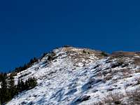
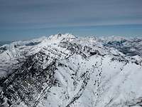
![Provo Peak]() There it was, looking oh so far away: the west ridge of Provo Peak
There it was, looking oh so far away: the west ridge of Provo Peakloud as I gazed down into the depths of the awaiting journey to the Rock Canyon CG. It looked like it was 20 miles away! But, on the other hand, a few hundred yards down the road I caught my first real view of what must be Provo Peak.
I reached the Rock Canyon CG turnoff in 2+35. Knowing I had another 2 miles
![Provo Peak]() Hey, 9 miles of travel and finally at the spot I had initially hoped to begin at!
Hey, 9 miles of travel and finally at the spot I had initially hoped to begin at!of gravel road to put under my soles before I would even be at the base of the west ridge, I began calculating a reasonable turn-around time for the day. Let's see, I needed to remember that on the return portion I would be tiring (I avoided the use of the phrase "wiped out") and that I wished
not to be hiking down in the dark. Hmmm. Sunset 'bout 5ish. I had better turn around no later than 1:30, regardless of where I was. It was discouraging to note that I had lost almost 700' descending down to this point. Yikes, I had about 1,300' to gain before I even stood at the intersection of the road with the west ridge.
Switchbacking for another one hour and twenty minutes found me gawking at the west shoulder's unceremonius intersection with the Squaw Peak road. There the road took a sharp left turn, began a gradual descent and then etched itself plainly on the west side of a prominent long ridge leading in a southerly direction, to Hobble Creek I supposed. The paucity of snow allowed the distinct ruts of an ATV trail to show the way up the west ridge's lower humps. I followed the trail too far, winding up on the drifted and often aggravating sugar snow of the ridge's north side.
I donned snowshoes (yes, I had carried those suckers all the way up here) and struggled over terraces and up steep slopes, finally cutting south through a thick stand of pine trees to get back up on the ridge. That slogging ate up another hour, and at 1:15, huffing and puffing on the mostly bare ridge, I slung my pack to the ground, took a break and called it good. There would be no summit rally, no whooping-it-up call of triumph to signal the top.
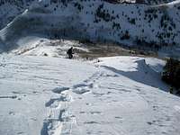
![The West Ridge at 9,500]() Looking up from 9,500'. No, that is not the summit!
Looking up from 9,500'. No, that is not the summit!![West ridge - looking down from 9,500]() Well, I see the road down there, so I'm going straight down.
Well, I see the road down there, so I'm going straight down.
Launching the return trip at 1:30, I headed straight down; there was little snow but lots of frozen grass clumps and some brush to contend with. Thirty minutes later - at 2 o'clock - I was again standing on the Squaw Peak Road, not certain I wanted to retrace all of those steps I had taken. However, it was going to be a lot of down and only - gulp! - 700' of up to get me back to my vehicle.
As I passed by the Rock Canyon CG I thought I heard the roar or the whine of engines: could it be that there were actually other living beings back here? Was someone using a chainsaw? I was tired; my feet were beginning to complain. I had a 40-minute grind up to the high point on the road. Seven hundred stinkin' feet - hey, I can do this. Afterall, it was then 3:15 and darkness was less than 2 hours away.
During the climb out of the Rock Canyon area the mystery of the roaring engines was solved: two ATVers passed by me, waving courteously and making a racket which severed the canyon silence like acid eating into metal. But very soon the noise stopped as suddenly as it had begun. Ten minutes later I followed the road around a sharp turn and noticed the two parked ATVs, the riders nowhere in sight. Huh, they must be taking a break or something.
I approached the aforementioned road highpoint and once again heard the distinct rumble of the ATV engines. They were coming up the road behind me. One passed me, and the second rider slowed until along side my path. The driver asked me if I wanted a ride out. I realized then that the driver was a woman bundled in a dark snowsuit. Introducing herself as "Debbie," she pointed to a small round table strapped to the back of her machine: we would just have to figure out a different place for it. With 6 miles still ahead of me, I didn't have to waver about answering in the affirmative. If she was offering, I was certainly accepting!
We re-arranged the table she had found at an overlook back down the road - she wasn't about to leave a nice table like that - and I swung myself up on to the rear seat. We must have made a curious sight what with the table now sitting so that the circular glass top was acting as a makeshift windshield and the table legs pointing back like tiny contrails. I half grasped the table legs, half clung to Debbie's jacket and we were off like a suitor late for dinner at his girlfriend's parent's house.
Debbie was very familiar with her ATV's performance capabilities and took those switchback corners fast to prove it. Several times I nearly wondered aloud if I had done the prudent thing in accepting this hair-raising ride. But, yes, the answer was yes. When we came to a gentle stop next to my parked car, I dismounted like a tenderfoot who had ridden his dude ranch rental horse about 6 hours too long.
![A Good Samaritan]() Debbie, the Good Samaritan who came to the rescue, table and all.
Debbie, the Good Samaritan who came to the rescue, table and all.
I couldn't thank Debbie enough. Her generosity had prevented me from having to walk 6 additional miles, almost half of which would have certainly been undertaken in the late autumn darkness. And the boisterous ride gave me the shot of adrenalin I needed to make the drive home with zero hint of being tired. And so the first attempt to climb Provo Peak came to a rip-roaring conclusion, but I resolved then and there to top out on this mountain sometime before the coming winter turned to spring.
Really Digging In: Attempt number two
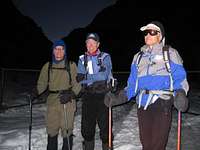
January 10, 2009. I had done some homwork since my first try back in late November, and I had recruited two dedicated and fit hiking buddies to complement my efforts, Dave and Brent. Armed with new information about a more direct route to the now infamous west ridge, we drove to the Rock Canyon TH high on the east bench of Provo, and hoped to be on our way at 7 o'clock.
![Provo Peak]() Raring and ready to go at the Rock Canyon TH.
Raring and ready to go at the Rock Canyon TH.
The TH (5175') was easy to find in spite of the pre-dawn darkness. The eighteen degrees would, we anticipated, be our coldest temperature of the day. There were already several other cars parked at the TH, and two snowshoers were bundling up and strapping on their equipment, too.
We set out at 7:20, the compacted snow and ice clearly marking the trail which led east through a narrow gap in the silhouetted mountains. We wore our snowshoes but ascertained after a few minutes that we could have left them on our packs for at least the first hour. We climbed steadily along the iced path, passed a concrete chlorinator building, passed around a closed gate and met 4 or 5 other outdoor enthusiasts as they were returning from their very early morning workouts. The two fellows we had met back in the parking lot were going to try Squaw Peak, a picturesque peak flanking us on our north side. We were intent on proceeding east to the Rock Canyon CG where we would intersect the road I had traveled 1 1/2 months ago.
We reached the first signs of the CG, a diminuitive restroom building isolated by 3-foot deep snow drifts, at 8:45. Oh, oh. Mixed emotions: we were encouraged by our time to this point, but it was there that the well-trodden trail came to an abrupt end. Two separate snowstorms had swept across northern Utah earlier in the week, and the blanket of snow left in their wake was now a beautiful but difficult obstacle to tackle. We looked at each other, formulated a plan for alternating the trail breaking duties and crossed our fingers that the road above us would have been tamped down by energetic snowmobilers.
Trudging through the campground at what seemed like a snail's pace, we followed FS trail 060 which led through a lazily snaking gully to the Squaw Peak Road. The effort ate up 35 minutes; the bright brilliance of the snow forced us to don sunglasses. As we inched our way over the lip of the road we saw immediately that our work was only beginning: there was no trace of snowmobile tracks or any other tracks. The road looked like a river of combed cotton which disappeared silently into the trees 1/4 mile ahead. As Gomer Pyle was wont to say, "Surpriiiise, surpriiise, surpriiiise!"
Striking out in single file we changed the lead every ten minutes, all of us noting how utterly easy the third position was and how frustratingly hard the first. The grade of the zigzagging road was gentle, but even the genteel nature of the climb couldn't mask the plodding and monotonous hard work that was embodied in the trail breaking efforts. We were truly a slug-like Conga line. Being "familiar" with the route, I was able to offer several suggestions for cutting off a switchback now and then. The only drawback to cutting through was the increased angle of the slope during the shortcut.
It took us 3 hours to climb 1,300' and cover about two miles. There was no quick or easy way to get around it. As we tortuously mushed toward the vee-shaped intersection of the Provo Peak west shoulder with the smaller mountains to the west, we discussed two things: (1) this trail breaking was eating up valuable time and (2) what did it mean to see those plumes of snow trailing off the summit?
![Provo Peak]() Ahem, is that snow blowing off of the ridge? And at what speed, may I ask?
Ahem, is that snow blowing off of the ridge? And at what speed, may I ask? The broken cloud deck was racing north-to-south like a bullet train. There would be wind, and plenty of it. We had hoped that the jet stream slicing over the state of Utah diagonally from the northwest to the southeast would have been nudged eastward by the high pressure system over California. It hadn't happened.
As we stood at the base of the shoulder and gazed up the west ridge, a chill swept over us. The wind was scraping snow from the north side of the entire ridge and launching it into the crisp air - it was not that much warmer now - directly where we would be attempting to ascend to the summit. Mother Nature had played a double trick on us: she had dumped copious amounts of snow, and now she was going to hammer us with her own form of sandblasting as we climbed the three thousand feet worth of ridgeline.
![Provo Peak]() Dave leads us through a young stand of aspens on the lower, more rounded section of the west ridge.
Dave leads us through a young stand of aspens on the lower, more rounded section of the west ridge.
Well, we were there, we would try and see what fate would deliver. We would be optimistic and the wind would lessen or abate by the time we were higher and peace would break out in the Middle East. What happened was an ugly dose of reality: more and more difficult trail breaking over steeper and steeper terrain. On the narrower and more distinct ridge above 8,700' the snow conditions were a mix of crusty granular snow and iced-over drifts. We never knew when we would break through the crust and plunge into half a foot of sugar snow or when we would simply plant a snowshoe and move forward as if on concrete.
The higher we climbed the more fiercely the wind blasted. I felt like I then knew what it might be like to be hit with birdshot. The drop off the north side of the ridge was at about a 70 degree angle. The wind picked up the helpless snow granules, accelerated them up the slope and launched them further to the south two or three feet above the actual ridgeline. Had I not been so miserable I might have marveled at the natural beauty of the scene.
Above 9,500' pockets of bared rock began to add to the torture. The added measure of stress, now having to be doubly careful with each step, only heaped on us the humiliation the elements were so generously bestowing. I squinted up as often as I dared, each time baring more of my face to the white barrage which seemed to strengthen with every step. It was a test of wills, and we were losing. Could that possibly be the summit up there? And how on earth could those bedraggled trees survive this kind of attack? Dave was taking shelter behind a small stand of stunted pine trees when I reached him. It was relatively warm there, but I use the term loosely. Taking out my GPS I hoped to see an elevation nearing 11,000'. My hopes were dashed in a heartbeat: 10,250'! No, no, the instrument must be wrong.
We vainly pushed on for another agonizing ten minutes before I turned to Dave and Brent and shouted, "We'd better go back!" We were already 45 minutes past our two o'clock turnaround time. I had called the climb to a merciful end. All of us we were cold and nearing the point of screaming. And we knew it would not get any better until we had come down off the ridge and fled the teeth of the wind. I don't have a degree in anemometry, but the winds were undoubtedly smashing us at 30-40 mph and gusting to perhaps 50 mph. Somebody "up there" was telling us in no uncertain terms that the summit was going to remain unconquered that day.
![Provo Peak]() Not yet out of the maelstrom, I stopped long enough to take this picture of where we had been tortured.
Not yet out of the maelstrom, I stopped long enough to take this picture of where we had been tortured.![Provo Peak]() After taking the photo looking up, I turned and captured Brent as he continued down. My regard for nature photographers increased exponentially during this 30-second photo-shoot!
After taking the photo looking up, I turned and captured Brent as he continued down. My regard for nature photographers increased exponentially during this 30-second photo-shoot!
Getting down was almost more painful than getting up had been. The wind? Numbing, bone-chilling, its icy fangs continuing to snap and snarl. The rocky, stone-strewn areas? More difficult to negotiate creeping down than they had been to climb through. The snow conditions? Crazier than before, our weight crashing down more forcefully now that gravity was aiding us. We were no longer in formal single file but rather in an "every-man-for-himself" formation, a gaggle intent on one thing and one thing only: getting out of that infernal wind. Needless to say, we weren't in a picture-taking mood when all of this was happening!
![Provo Peak]() At the ridge base Brent is still shivering from the icy descent.
At the ridge base Brent is still shivering from the icy descent.
When we reached the base of the ridge the wind was just a perturbing breeze. We checked each other's faces to make sure the skin was still intact. The sun was slowly arcing to the southwest above a layer of high thin clouds, below us the deepening shadows of the canyon waited stoically. We had labored upwards for 7+45, and those nearly 8 hours had burned up plenty of calories and energy. We didn't worry about getting out in daylight because we knew that would not be possible (where's a zipline when you need it?). We calculated that we wanted to be at the CG before dark. That would be reasonable. And we achieved that goal.
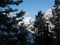
![Provo Peak]() Still basking in the afternoon sunshine, Mt. Timpanogos sits majestically to our north.
Still basking in the afternoon sunshine, Mt. Timpanogos sits majestically to our north.![Provo Peak]() Cascade Peak, east of the Rock Canyon CG, poses for us during the journey back. It would have been a crime to not enjoy these memorable views.
Cascade Peak, east of the Rock Canyon CG, poses for us during the journey back. It would have been a crime to not enjoy these memorable views.
Taking about 2+15 to reach the CG, we were able to cut off two more switchbacks by plunging down steep slopes of stable snow; the variety of the return path helped to raise our spirits. At the CG we strapped on our Petzl headlamps and walked the remainder of the descent out with the abundant snow reflecting every particle of light possible. Soon the city lights of Provo became visible, and we focused on walking out without any sprained ankles. During the last 30 minutes of our descent we met 5 or 6 people who were heading up, two of them toting old-fashioned sleds, the kind with steel red runners and long wooden slats on top. Whaaaat? Oh, well, to each his own.
After 11+30 total elapsed time we reached the TH parking lot, tired but satisfied with our efforts. No, we hadn't reached the top, but we felt that we had truly done all we could. It had truly been a team effort. Even if we had had more people in the group to help break trail, we weren't sure any of us could have withstood the raging winds all the way to the top. As yet two more hardy souls prepared to head up, we asked them if it weren't too dark to be thinking about starting. They said there was going to be a full moon. Ah ha! So that was the motivation of those we had met a few minutes ago. And, as if on cue, we turned to look back at the canyon and the full moon (it would actually be full the following night) was beginning to peek over the shoulder of Squaw Peak. But we were safe and the mountain would be there for another attempt. Next week, maybe? Hmmmm...
Full Scale Attack: Attempt number three
January 17, 2009. Yes, one week after the trail breaking exercise and the brutal face off (excuse the pun) with the pounding winds I returned to finish the job, this time with an extraordinary team. Joining Dave, Brent and me were Christine and Zeejay, two of the finest female mountaineers I have ever been privileged to know.
Since the previous attempt high pressure had slid over the entire state of Utah. The result of cold air and high pressure means one thing along the Wasatch Front: inversion. The result was a cold, depressing blanket of pollution smothering low-lying valleys. This included Salt Lake and Provo, so our drive south to Provo was made in this gunk.
However, if there was one good thing about an inversion it was that clear blue skies and warmer temperatures reigned above the top of the inversion soup. Winds would be light, too. As we departed the now familiar TH at 6:45 a.m. our goal was to reach the summit in 6 hours or less. We were banking on the fact that without a doubt snowmobilers would have been racing up and down the Squaw Peak Road during the past 7 days of relative calm weather.
![Provo Peak]() Zeejay & Christine maneuver up a steep shortcut ridge, nearing the spot where the snowmobile tracks abruptly ended.
Zeejay & Christine maneuver up a steep shortcut ridge, nearing the spot where the snowmobile tracks abruptly ended.We booted it to the Rock Canyon CG. The tempo of the ascent matched the mood: positive, energetic and replete with optimism. We attained the road by following not only our week-old tracks but additional tracks from back-country skiers. At the road we were not disappointed; snowmobile tracks had packed the snow down in both directions. Hooray! The packed snow was still softer than we had thought it would be, but it allowed us to choose between either boots or snowshoes, and, of course, our pace was brisk compared to the previous week's slog.
About half way to the base of the west shoulder we were surprised and disappointed to find a spot in the road at which the snowmobilers had turned around. Alas, no more help from them. The best we could do was plod along in our own tracks from last week. But even that allowed us to move along faster than a week ago. In addition, we had the advantage of five people alternating lead changes. As a result we reached the bottom of the west ridge in under two total hours from the CG - last week it had taken 3 hours.
We had expected to be basking in luxurious sunshine at this point, but a high layer of cirrus clouds had unexpectedly slid across northern Utah and depressed the temperatures slightly. Buoyed by the fact that we had reached the ridge in 3 1/2 hours we eagerly began tackling the final 2,700' of our climb. Winds had all but filled in much of our old tracks with snow, but occasionally we found them and used them whenever possible. We picked up an intermittent southerly breeze somewhere after leaving the road, but it was no impediment to our steady, measured march upward.
As soon as we neared the area where the rocks were exposed we stowed our
![Provo Peak]() Christine pauses while Brent continues his steady pace. We have replaced snowshoes with other gripping devices.
Christine pauses while Brent continues his steady pace. We have replaced snowshoes with other gripping devices.snowshoes on our packs and changed gear: Dave, Christine and Brent donned their Katoola mini-spikes, Zeejay strapped on a pair of nifty lightweight Grivel crampons and I used my heavy but reliable Stabilicers. Navigating over the rocks, around random angular boulders and hardy pine trees, we continued at a steady pace, the five of us in a loosely organized ragged line. Three distinct times we glanced up and figured that the summit was "right there," only to find that we been fooled. In exasperation Christine, staring up at a fourth summit-like mound of snow, queried one more time, "Do you think THAT is the top?" I was leading. I paused and glanced at my watch; it was 12:25. I looked up and without thinking responded, "Yup, that's it for sure." I was taking a chance, but somehow I felt sure that I was right.
![Provo Peak]() Looking south I captured Christine's final steps to the summit mound. In the distance is the pointed summit of Mt. Nebo, tallest peak in the Wasatch.
Looking south I captured Christine's final steps to the summit mound. In the distance is the pointed summit of Mt. Nebo, tallest peak in the Wasatch. Three minutes later at 12:28 I reached the gently-rounded snow-covered summit of Provo Peak. I turned to watch Christine take her final dozen steps to join me and I let out a victory whoop appropriate for our success. Zeejay, Brent and Dave joined
![Provo Peak]() Inspiring views in all directions. This view to the north showcases Cascade Peak, Timpanogos and even Lone Peak (squint and you'll see it!).
Inspiring views in all directions. This view to the north showcases Cascade Peak, Timpanogos and even Lone Peak (squint and you'll see it!). us quickly and we all celebrated reaching the top in 5+43, exactly our goal. At last, the top. It had been eluding me for nearly two months, but now it was mine - no, it was ours! I could never have done it without the hard work, patience and good will of my solid-as-a-rock friends.
![Provo Peak]() Our long-awaited much-anticipated summit photo. We left a small gap so that Timpanogos could be in the picture with us.
Our long-awaited much-anticipated summit photo. We left a small gap so that Timpanogos could be in the picture with us.We all marveled at the stark beauty surrounding us, the sweeping views in all directions. We had to take pictures; we grabbed something quick to eat, Brent his normal salmon sandwich on homemade bread, Zeejay the PBJ she had fashioned back home, Dave his CLIF bar, Christine a Luna bar and me my little package of store-bought cheese & crackers. Provo Peak summit - at last. My GPS read 11,065' at N40 14.659 W111 33.416.
Let's see: Pictures? Taken. Nourishment? Eaten. Gear? Collected and packed. Views? Tucked into the memory bank. Time to go. We left the prized summit at 12:45, precisely 6 hours after we had departed the dimly lit Rock Canyon TH. We were pumped, full of childlike enthusiasm and grateful for the shared experience. Some of us took the same way down that we had come up, others opted for the deeper snow, plunge-stepping at a lively pace.
Two-thirds of the way down we bumped into a lone snowshoer. He turned out to be Dave Tobler, a member of the Serac Mountaineering Club who had traveled with me and others to Mexico in 2007 to climb Ixta and Pico de Orizaba. He had taken an alternative route, over Y-mountain and down into Slide Canyon, then over to the ridge, but he didn't know if he would have time to make it to the summit. Small world, the world of mountaineering. Our time from summit to Squaw Peak Road was 1+15, and that included a stop for more food half way down.
Our trip out was uneventful for the most part. We took every shortcut we could; we reveled in plunging down steep snowy slopes, each of us making our own new set of tracks. For me, the terrain, the switchbacks, the shortcuts, the shapes of the mountains and hills rising on all sides, they all began to look familiar, a bit like old acquaintances calling to simply say, "Hello."
Soon the snowmobile tracks, then the drop down to the CG, then the packed snow down the canyon with the rocky beak of Squaw Peak straining to stay in the afternoon sunlight. It went by quickly. Too bad we had to descend into the murk of the inversion, but that was a small price to pay for the success we had shared. At the stroke of 4:30 p.m. we arrived back at the foggy TH. It had taken us a total of 3+45 to come down. Our entire adventure had taken only 9+45.
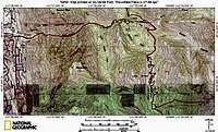
![Provo Peak]() Thanks to Zeejay for this bird's eye view of our route to the summit of Provo Peak. Her knowledge of GPS is, I think, without equal.
Thanks to Zeejay for this bird's eye view of our route to the summit of Provo Peak. Her knowledge of GPS is, I think, without equal.
It is my hope that this narrative will help others to enthusiastically anticipate climbing Provo Peak and that it will help them to avoid some of the obstacles which made my ultimate triumph so long in the making. And, yet, isn't it often times the journey which makes life exciting and not just the destination? Robert Service, the bard of the Yukon, said it well in his poem "The Spell of the Yukon." Said he, "There's gold and it's haunting and haunting; it's luring me on as of old. Yet it's not just the gold that I'm wanting, so much as just finding the gold." Climb on and be safe!
![Provo Peak]() A victory photo of The Team. Left to right: Christine, Dave, Moogie737, Zeejay, Brent.
A victory photo of The Team. Left to right: Christine, Dave, Moogie737, Zeejay, Brent.


Comments
Post a Comment