
|
|
Mountain/Rock |
|---|---|
|
|
37.76633°N / 118.70371°W |
|
|
Mono |
|
|
Spring, Summer, Fall |
|
|
11160 ft / 3402 m |
|
|
Overview
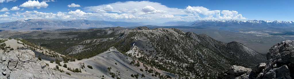
Glass Mountain is the highpoint of the Glass Mountain Range southeast of Mono Lake in central Mono County. Most of the peaks in the immediate area, including Glass Mountain, are part of the Long Valley Caldera and therefore volcanic in nature. The geology of Glass Mountains consists primarily of various lava domes and rhyolite or obsidian flows, mostly occurring from 2.1 to 0.8 million years ago.
The summit is usually accessed via a short but steep class 1 use trail in Inyo National Forest near Highway 120 in the Mono Basin area. The drive is scenic, and though the hike is short the views are outstanding and rewarding. The panorama includes much of the Sierra Nevada, the White Mountain Range, Mono Lake, and Owens Valley stretching off in various directions.

Getting There

Sawmill Meadows Road
Glass Mountain is most easily approached from Highway 120 between Lee Vining and Benton, California. There is a high-speed dirt road most of the drive, passable by low clearance vehicles. Note that Highway 120 passes through a lot of steep washes in this area. Although well paved, it is not a road that is drivable at excessive speeds, especially at night.
Sawmill Meadows Trailhead (37.77388° N, 118.68380° W)
From Benton, drive 13.6 miles west on Highway 120 and turn left onto unpaved but well graded and signed Black Canyon Road. If coming from Lee Vining the turnoff is 31.8 miles east of Highway 395. After 0.8 miles turn right at an intersection onto Sawmill Meadows Road and continue 6.6 miles to another intersection and turn left to stay on Sawmill Meadows Road. After 3.2 miles keep right and continue another 0.4 miles to an intersection with an old jeep road on the right. dshoshone reports that this jeep road has recently been closed by the USFS by placing a log across it, so park your vehicle here.
Route Description

Glass Mountain Trail

Route Map
Trip statistics from Sawmill Meadows Trailhead:
1.4 miles one-way, 2000 feet total elevation gain with negligible gain on the return
There is an excellent class 1 use trail through the volcanic cinders most of the route to the summit, if you lose it you will likely regain it shortly. Begin by following the old jeep road up 200 feet gain and 0.2 miles to the old trailhead. The trail then initially heads west up a drainage through lodgepole pines to a small saddle at 9880 feet. From here turn southwest and climb steeply towards the summit area which soon comes into view. Walk over a small saddle at 10820 feet and climb the east ridge of the final hill to the summit area.
Note that the highpoint is the south summit, just over one half mile south of and 40 feet higher than the north summit. The north summit has a radio repeater on top and is labeled Glass Mountain on the 1994 Glass Mountain Quad.
Red Tape
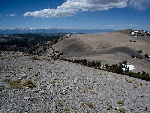
Looking North across the Summit Plateau
Glass Mountain lies in Inyo National Forest, but is not in a wilderness area and no permits or passes are required.
Mono Basin Scenic Area Ranger Station
P.O. Box 429
Lee Vining, CA 93541
Phone: (760) 647-3044
Current Conditions
Current NOAA / National Weather Service Forecast
For the latest mountain and road conditions check out the Inyo National Forest Mono Lake Ranger District Recreation Report.
When to Climb
Spring through fall is the most realistic time for a visit since Highway 120 is not plowed from Highway 395 to Benton in winter. Call ahead for road conditions in off-season periods. In early season expect some snow at the higher elevations.
 |
 |
 |
 |
 |
 |
Camping
Glass Mountain from the North
Dispersed camping is permitted throughout this portion of Inyo National Forest, just find a scenic spot anywhere on the drive in and pull over at will. Many roadside locations in the area are well shaded and have seasonal streams nearby. There is a nice location at Sawmill Creek near the intersection 0.4 miles before the trailhead, just shortly down the road if you turn left off of Sawmill Meadows Road.
For an established campsite, Sawmill Meadows Campground is also available for a fee just 0.5 miles further down the road from the jeep trail to the trailhead, at the end of the road. The campground has picnic tables and pit toilets available.
Etymology
Glass Mountain is in a volcanic area and was clearly was named after the large deposits of obsidian found in the vicinity. Pumice, ash, and black or brown obsidian can be found throughout the area, including much of the climbing route.