
-
 18389 Hits
-
 89.77% Score
-
 30 Votes
|
|
Mountain/Rock |
|---|---|
|
|
48.87345°N / 113.8302°W |
|
|
Scrambling |
|
|
Summer |
|
|
8159 ft / 2487 m |
|
|
Overview

Pardon what may seem like sentimental BS, but I'm going to wax a little poetic, or at least try, at the outset here in an attempt to do at least a tiny bit of the justice to this peak and this location that my departed friend Saintgrizzly would have had he climbed this peak and written this page.
Sometimes, we happen upon a place that is beyond remarkable. Sometimes, we happen upon a place that changes the ways we think and feel.
Pyramid Peak itself was not such a place, but the surroundings were. That's not to say Pyramid Peak is nothing special. It is special. It's deep in the wilderness, the views are phenomenal, nothing short of Class 3 will get you up top, and the final summit ridge and summit block have wildly exposed spots. Also, it's very spectacular to behold from a number of angles.
Yet, the neighborhood definitely enhances the property value in this case.
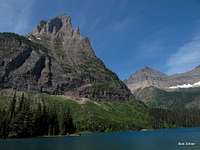
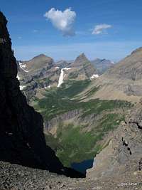
Glaciers. Alpine tarns. Ice-carved peaks. Wildflowers that no one sees. Wilderness, wilderness, wilderness in all directions. Wander off to the edge of the area and look down, and you will see Margaret and Ipasha Lakes, glacier-fed bodies, the former of which is a cloudy hue impossible to describe and quite possibly the most beautifully colored lake in all of Glacier National Park (it is at least the most beautiful of the many I have seen).
After just a few hours there, I knew that Sue Bench, from which I climbed Pyramid Peak, had become the place where some unlucky soul would have to leave my remains someday. There might be more beautiful places in Glacier National Park, but I have seen much of it and have not seen anything to compare with the area of Sue Bench. Considering my almost-religious feelings about Glacier, that says a lot.
Vernon would have had volumes to share. I can't match his fervor or his eloquence. And I also won't be sharing the pictures of the views. I want those views to be a reward to those willing to exert the effort to get out there. Magic experienced ought to be magic earned.

Getting There
From Babb, drive north on U.S. 89 for 4 miles and bear left at a junction, heading north on MT 17 to the U.S.-Canada border along the Chief Mountain International Scenic Byway. Drive 14 miles and just before the border, turn left into a large parking lot. This is the trailhead that accesses the Belly River section of the park, which has no roads and is purely backpacking country. Some day hikers head out here to fish, but most destination-worthy sites out here are too far from the trailhead for the average hiker to want to visit as a day trip.Route Information
Follow the valley of Belly River (you rarely come very close to the stream, though) for about 6 gentle miles (the first 1.5 mi entails a 700' elevation loss that is not much fun to end the hike out with) to signs pointing to Gable Creek Campground and Belly River Ranger Station. Note: You CANNOT pick up backcountry permits at this location and must get them from a permitting site elsewhere; the closest ones are at the Many Glacier ranger station and the St. Mary Visitor Center.Continue west up the valley and begin to ascend the drainage of the Mokowanis River. The trail remains gentle. If you are ever in doubt at a junction, remember that you are heading west and that you should follow signs indicating the way to Stoney Indian Pass.
Some key points:
* 8.3 mi from the TH-- Cosley Lake CG
* 10.3 mi-- Glenns Lake Foot CG
* 12.9 mi-- Glenns Lake Head CG
* 13.4 mi-- Mokowanis Junction. Keep west. The campground of the same name is a short distance away. Heading south leads to Mokowanis Lake and a campground there. These are the last campgrounds on this side of Stoney Indian Pass and the closest to Pyramid Peak.
From Mokowanis Junction, it's still over four miles to Stoney Indian Pass. Not long after the junction, the trail begins to steepen as it climbs past some spectacular waterfalls to Atsina Lake. Past the lake, the trail steepens again and the scenery starts becoming nothing short of amazing.
You are going to leave the trail where it crosses the Mokowanis River just upstream from its plunge over Paiota Falls. The river drops over Raven Quiver Falls above as it leaves its source, stunningly beautiful Sue Lake, which itself frames unforgettable views of Mount Kipp, Shepard Glacier, and Cathedral Peak.
 Paiota Falls Paiota Falls |
 Raven Quiver Falls Raven Quiver Falls |
The point of leaving the trail is 2-2.5 mi from Mokowanis Junction, or about 16-16.5 mi from the trailhead.
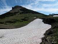
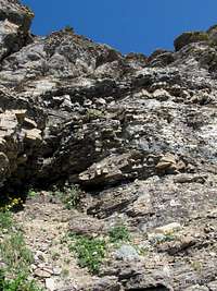
Basically, you need to head south a bit and then head east up grassy and rocky slopes to Sue Bench. There are two ways to start out that will keep you out of awful willows. The first is to spot a use trail just before the stream crossing. Although the Park Service has closed that trail, it is easy to see (see picture below). This trail does not last long, but it is fairly simple to follow the streams here and stay in the open until the willows are behind you and the terrain gets steeper and rockier. The other way is to cross the stream and then ascend, but you need to do so almost where the mountain wall rises or you will find yourself in tall, dense willows that are miserable. I ended up in these during my descent, and it took me about 10 minutes to get through about a tenth-mile of them.

The slopes leading east are very apparent and easy to follow (see first picture below).
 |
 |
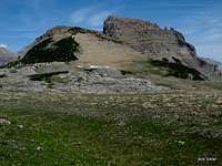
Now head northeast up the ridge to Pyramid Peak. From the trail, you will already have noticed a deep notch between two summits on the peak. Yes, you have to descend into that notch, but no, the elevation loss is not as bad as it appears to be from above. It's not even 200'.
 |
 |
 |
 |
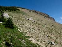
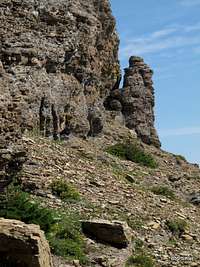
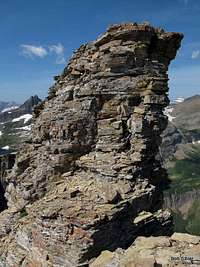
From the notch, ascend NE below the summit cliffs, working higher whenever possible. Find the first good weakness-- a system of Class 3 ledges and gullies-- leading to the summit ridge. The second picture below shows the weakness; the third serves the purpose of showing you where not to head and to ascend well before you get to the formations shown.
 |
 |
 |
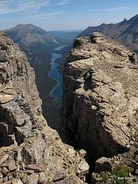
Parts of the summit ridge are very narrow and very exposed, especially on the north side. The summit block is Class 3 and features exposure as well. Atsina Lake is almost 2500' below, and that is about where you would end up if you fell.
 |
 |
 |
Enjoy the views and take lots of pictures. You won't see scenery like this in too many other places in the U.S., not even in Glacier.
Mountains ring you. Almost due north is Mount Cleveland, Glacier's highest peak. Turning clockwise, you see Glenns and Cosley Lakes, Mount Merritt (another of Glacier's six 10,000'+ peaks), the still-unclimbed Lithoid Cusp, Ipasha Peak, Margaret Lake (below those last three), Chaney Glacier and the Continental Divide, Mount Kipp, Sue Lake, Cathedral Peak, Wahcheechee Mountain, Stoney Indian Pass, and the Stoney Indian Peaks. Of course, there is much more to see, but these are the highlights, and they are indeed some of the finest jewels in all of Glacier.
The elevation gain from Cosley or Glenns Lake is about 3400'. One-way distance from the trailhead is approximately 18 miles.
Other Approaches
The shortest way to get to Pyramid Peak is actually to hike in from Goat Haunt, but that requires the red tape of a border crossing and a boat ride across Waterton Lake in Canada. Thus, this page focuses on the approach from the east and within the U.S.
There is also a way from the Highline Trail, but the campgrounds involved are very difficult to obtain permits for, and there is considerable off-trail travel, including a glacier descent, so I am not going to recommend or cover it here. For details about it, see J. Gordon Edwards's A Climber's Guide to Glacier National Park.
Red Tape
As of 2012, the park entrance fee was $25, good for a week. Annual and Interagency passes are available for more money but are a better deal. Although you don't have to go through an entrance station to reach the trailhead decribed on this page, you do have to go through one in order to get to a permit-issuing ranger station.Trailhead signs cover all the wilderness regulations, so please read them carefully.
This is grizzly country. Carry pepper spray on your person (not in your pack) and know in advance how to use it. The bells some hikers wear have no proven deterrent effect; because they make a high-frequency sound and bears respond better to low frequencies, the bears may often not even hear them, but hikers seeking the natural sounds of the wilderness most certainly do. While the NPS does not officially recommend against the bells, many rangers will privately do so, and the NPS does strongly recommend having pepper spray.
Although it is now legal to carry firearms in national parks, statistics show that pepper spray is a more effective defense than a gun. Most handguns do not have the power to kill an adult grizzly unless you hit it in the eye, anyway, so firing on a charging grizzly, if you even have the time and steady nerve to do so, may just leave you facing a wounded and enraged animal that weighs several hundred pounds and has claws long and sharp enough to gut you in a single swipe.