Background
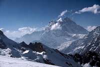
![Gauri Shankar from Ramdung Peak High Camp]() Gauri Shankar was to dominate the views from Ramdung
Gauri Shankar was to dominate the views from RamdungA group of us had trekked in the Khumbu the year before, and like many people at the time had thought that one trip would get the itch out of our system, WRONG! It became clear very early on in that trip that most of us had a yearning to climb something higher than Gokyo Ri or Kala Patar. We got a taste of something more exciting on Taweche Towers, a rarely frequented rocky spire above Pangboche. But really we wanted a proper Himalayan summit, not a viewpoint tacked on the side of something bigger.
Over several long evenings of whisky fueled discussions on the meaning of life, we formulated a plan to come back to Nepal and climb a "Trekking Peak", as described in Bill O'Connor's excellent book. Our trek leader, Andy, was fed up of working for other people, so he decided to set up his own company and organise the trip. Mera is the highest, isn't too technical, well within our range of skills we thought, so we made our plans and tried not to get too excited!
The next year went by very slowly. Andy got round all his previous punters that had expressed an interest in something like this, and gathered the team. We all spent as much time on the hill as possible, getting fitter and honing our skills. We also read everything we could find on Mera Peak, and by the time of the trip I reckon we could have climbed it in our sleep. The flight to Nepal and the usual couple of days sightseeing in Kathmandu were a blur, but everything came into brilliant focus early one morning at Kathmandu airport.
I suspect many of you have sat in that airport, watching as your bags are packed onto the little Twin Otter plane that will take you to Lukla and the Khumbu. The excitement mounts, any second now you'll get the call to board the plane and the adventure will begin. But doesn't your heart sink when you see all the bags being taken off the plane again! The sky is clear blue, there must be a problem with the plane, don't worry, they'll find another, but they never do. The problem is cloud at Lukla. The clear early morning always turns to cloud at some point in the day, you just hope you get there before it all closes in. I have a terrible photo of our group sitting on kit-bags at the airport waiting for a taxi back to the hotel that we had just checked out of. Talk about depressed, it makes me want to slash my wrists just looking at that photo even now.
But that is nothing to how we looked when the same thing happened the next day as well! Andy and our sirdar Ang Kami did a brilliant job that day, rushing round the various government offices in Kathmandu, trying to find a way out of this mess. For hours it looked like we would just have to wait for a flight, but time was running out. We couldn't afford to lose many more days and still climb Mera. Then late in the day, blessed relief. A guy at the permits office took pity on us and offered us a permit to trek the Rowaling Valley and climb Ramdung Peak instead.
We knew nothing of Ramdung. The Rowaling Valley had been closed for 10 years and only re-opened to trekkers and climbers a month before. Apparently one group had just got back from Ramdung, but they didn't get near the summit because of heavy snow, ho-hum. We cobbled together a few handwritten notes on the route, and the following morning set off for our mountain, by bus!
The Approach
![Magic Morning]() A magical morning at the village of Beding in the Rowaling Valley.
A magical morning at the village of Beding in the Rowaling Valley. There was some irony in the fact that we were on the road that Everest climbers had to take before the airfield was established at Lukla. We didn't go all the way to Jiri though, stopping at Charikot, a market town characterised by lots of houses on stilts at the top of a steep slope. From Charikot the trail dropped steeply down to the Tamba Khosi valley, a deeply incised gash heading north towards the snowcapped peaks. The valley bottom was lush, with many tidy villages, but our eyes were forever drawn to the mighty triple topped peak of Gauri Shankar up ahead.
Eventually we had to leave the flat valley bottom and climb steeply up to the east into the hidden mouth of the Rowaling Valley. As the trail levelled out we came to a school, where all the pupils were sitting outside with their books, despite there being a brand new building to sit in. Mind you, if I had that view I wouldn't sit inside either! The Rowaling has a very secretive appearance from here. Not only is it hidden away up high on the side of the main Tamba Khosi, but the entrance is quite narrow, giving no hint as to the delights that lay inside.
The valley twisted and turned, and views were restricted by steep cliffs and forest. We were shown a tiger trap, and once we had to have lunch in a cave because there wasnt any other shelter from the snow. It felt totally different to the hustle and bustle of the Khumbu. We were reminded that the Rowaling was where Shipton found the famous yeti footprint back in 1951! There is only one large village in the Rowaling, and we reached Beding in a heavy snowstorm. That evening we were invited into a local house, where our host delighted by feeding us his homemade chilli chips and chang (homebrew). The chang was great, and the chilli chips even better, quite a combination actually. I gained some kudos with the locals because I was the only person to eat all the flesh disolving chips!
The morning dawned clear and bright, with heavy snow all around. We acclimatised by a short trek up the north side of the valley towards the Tibetan border, and it really did feel like frontier country. The following day we moved up the valley to the summer yak pasture of Na, and explored further towards the Tsho Rolpa lake and the pass that leads over to Thame and the Khumbu. From here we got our first views of Ramdung and the route to it, on the south side of the main valley. We also had a big scare when one of our party suddenly became very ill.
Altitude sickness had hit Alexa very quickly, you could hear the fluid gurgling on her chest. We got her into a sleeping bag in a tent and while we assessed her situation. For some reason I ended up on "vomit duty", clearing up the most horrendous flourescent green liquid with black chunks in it. The smell was indescribable, so I won't try to describe it! It was clear that Alexa had to go back to a lower altitude immediately, and 2 sherpas were "volunteered" to take her to safety. Alexa wouldn't hear of anyone else giving up their summit to stick with her, anyway, she was going to have her own adventures with the sherpas down the valley, and she did too!
The snow cleared quickly in the valley and we moved to basecamp in a grassy bowl about 1000' higher than the valley floor. From here we watched as Himalayan Thar ran across the precipitous crags opposite us. The weather was set fair, we just hoped that the recent snow was consolidating up above us. The next day we pushed up to the Ramdung Glacier. There is a big icefall on the nose of the glacier, but it is easily turned on the left. We then proceeded on the glacier, and set up our high camp just below another ice fall.
Summit Attempt
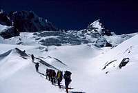
![Approaching the Ramdung Glacier]() Approaching the Ramdung Glacier
Approaching the Ramdung Glacier Our high camp was a stunning place, certainly the most spectacular place any of us had ever camped. Above us was the second icefall on the Ramdung Glacier. To our right were towering cliffs. And infront of us was Gauri Shankar with it's permanent cloud plume, Shishapangma in the distance to the left, and Menlungtse peeping over the peaks forming the barrier of the Tibetan border on the north side of the valley below us. We all sat outside drinking tea and taking photographs until the cold finally drove us into the tents.
The morning was the coldest I've ever experienced, and we had the usual battle with lethargy to get our boots on and the gear sorted. But several cups of tea and bowls of porridge later and we were off. The second icefall was also turned to the left, and the going was relatively easy on firm snow. After a couple of hours we reached a broad col, and the wind hit us. Ahead was our peak, revealed at last, an icy dome beyond a large shallow bowl. It still seemed a long way off, although the ground looked easy. The wind was a problem now though, and the snow in the bowl beyond the col was deep and soft, it was getting really tough going. Four people dropped out at this stage, knowing their bodies well, and also knowing that the snow conditions weren't likely to get better as the day wore on.
On the far side of the bowl the snow got firmer again for a while, then we had a large crevasse to negotiate. Beyond this we started to feel that we were going to get our summit. It was closer now and the wind didn't seem too bad anymore. But when we reached the foot of the final dome the wind hit us again. We had trouble even standing as we discussed the final few metres. The dome isn't difficult in good conditions, but it was covered in hard sheet ice when we were there. We could have climbed it, but it would have been slow, and we simply couldn't stand still for long in this wind. If we didn't get blown off we'd be frozen to death. The decision was painful but simple, we had to turn back.
The moment I turned back into the wind the tip of my nose started to freeze. There was a small gap between my goggles and balaclava, and the wind had found it. We estimated the wind chill at about minus 50 degrees, which is a record for me at least. We got down out of the worst of the wind fairly quickly, but then the crossing of the snow bowl was tortuous at best. As we climbed up the other side to the col we were exhausted. The snow now had a thin crust of windslab on it, and we broke through at every step. On the col itself tempers got frayed. If the wind didn't blow you over, then someone else on the rope would fall over and pull you down with them. Eventually we got over the col and could see the camp below us, the rest was easy in comparison. The rest of the team had seen us from afar, and by the time we arrived at the tents the kettles had boiled, more teas all round!
Postscript
![Chorten at Sunset]() Beding Sunset
Beding Sunset The descent was a joy. Energy returned as we lost height and the valley was warm and welcoming. Back in Beding we were treated to one of the most glorious sunsets I've ever seen. The river seemed to catch fire, burning orange as the mountains turned purple, and the mist descended and took on all the colours of the rainbow. Later we met up with Alexa and the whole team was one again. We tried desperately to learn the rules to Nepalese Rummy, but we never did stop being fleeced by the sherpas! Then on our last night before Charikot we had a major party with the whole crew, sherpas, porters, trekkers, all united in a frenzy of singing and dancing. We had barbecued fish caught in the river by the camp, and the cook even managed to bake a cake in a pan on the kerosene burner, pure magic.
But the adventure wasn't over yet. We arrived at Charikot in the middle of a petrol shortage, but Ang Khami managed to find a bus with a full tank, so long as we got up at 5am and shared with some manic Russian and Korean climbers. They were great value on the drive back to Kathmandu to say the least.
Did we regret not climbing Mera Peak? Not one little bit. Ramdung and the Rowaling was far more interesting, even if we missed out on our summit in the end. The Rowaling is no doubt far busier now than it was in 1989, but I would still recommend it. I know that some groups now climb Ramdung and Parchermo as a double trip. Walking into the Rowaling, then across to the Khumbu and back via Lukla.


Comments
Post a Comment