An epic ridgewalk in Glacier National Park
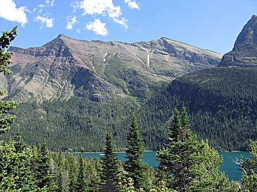
![Red Eagle Mountain]() Red Eagle Mountain
Red Eagle MountainAn Epic Ridgewalk in Glacier
Early on 9/18/94, I left Whitefish, MT, for an exploratory climb of Red Eagle Mountain on the southeastern shore of St Mary Lake in Glacier National Park. I made easy progress over Going to the Sun Road before sunrise with no traffic to hinder my 50 mile drive through the park to within 2 miles of the Saint Mary park entrance. It started to get a little light in the eastern sky as I passed by Two Dog Flats and, perhaps appropriately, there was a pair of coyotes trotting east in the middle of the road in front of my headlights which was something I had never witnessed before.
I took the short road to the south just before the park entrance which goes about .5 mile to the trailhead parking for the trail to Red Eagle Lake and noted that there was a breeze from the west shaking the aspen trees. The weather forecast was excellent and excitement was in the air at 7 am as I headed along the trail making little noise, but alert to the drill of grabbing my bear spray at the first sign of danger. Within a mile I surprised a bull moose along the trail which had the same or greater impact on my nerves. He took off into the bushes and I once again had the trail to myself.
Perhaps another mile passed uneventfully when I began to overtake some creature shuffling up a small hill in front of me and also upwind. Since I was moving smoothly and quietly, it was not long before I was getting quite close to something I didn’t recognize or have much concern about since it was built close to the ground and I probably outweighed it 5 to 1. Perhaps good sense, or more likely, curiosity, suggested that I make some sound to alert my companion to my presence. His reaction was rather comical initially, but quickly turned intimidating as he sort of jumped and spun around to see what was up when I made a sound followed by a louder similar sound when the first one didn’t provoke a reaction. My creature was the first badger I had ever encountered and it seemed to magically grow about double in size and began marching toward me causing me to extract my bear spray and remove the safety for possible defense! I gradually retreated and the badger finally walked off the trail and went down a hole. I thought a picture might be in order if it came back up so I approached with camera in one hand and bear spray in the other to hedge my bets. Turned out to be not enough natural light for a picture yet and an unwilling star, so I resumed my journey.
Isn’t this what hiking in wild country is all about…coyotes, moose, badger, fresh air and occasional bugling of elk in the fall rut? My hike was hardly started and before another hour passed I began to get closer to the bugling. By this time, I was almost out of touch with my initial plan of climbing some new peaks. The old bull closest to the trail had 3 or 4 cows herded up and was in communication with a challenger somewhere in the distance. He was so intent on his rival, that I was able to move quite close before the cows noticed me and took off. I froze behind some trees and watched the bull try to figure out what had spooked them and finally decide to follow rather than lead.
After the elk show, I was halfway expecting to get a royal straight with a bear or two, but happily watched a couple of deer bound off to close the curtain on my wildlife sightings for the day. After about 5 miles of hiking, the trail intersects with the St Mary Lake trail on the right, which I decided to follow hoping to find a way to get above tree line of the eastern end of Red Eagle Mtn where I planned to begin my climb up the ridge. No one that I had talked to knew a route to recommend from this approach, so it was based on topos and intuition. I followed this trail gaining elevation and watching for a break in the bush whack that promised to greet me as soon as I stepped off the trail. Before long, I was rounding the northeast end of the mountain without having spotted any likely game trail or scree slope to ease my transition from the forest to the slopes above tree line. I decided to double back to take a better look and finally dove into one of Glacier’s trademark bushwhacks. It probably took 45 minutes to force my way through, over, around and under downfalls and thick shrubs before I finally saw the light at the end of the tunnel and broke out onto the rocky slopes leading up the ridge line.
From this point the scrambling was pretty standard for GNP with lots of loose rock placed at a steep angle and the sun was warming the day making the breeze even more welcome as I climbed toward what looked like a summit, but was only the first of several false spirit enhancers. There were even cairns on several of the more substantial bumps on the ridge. The views north and south were tremendous and eventually I reached the true summit which was somewhat anticlimactic compared to several I had passed on the way.
I stopped to sign the register and consider my options. There was still a lot of the day remaining and I had done the majority of the vertical needed to get high in Glacier, so I studied Mahtotopa while eating a snack and decided to go for two peaks this trip. After about 10 minutes, I shouldered my daypack and moved on toward my new goal. The ridgeline was good hiking as I had read in the Climber’s Guide, by Gordon Edwards and I made steady progress until I was on top of Mahtotopa. Pleased with my effort I started to speculate on how long it would take to keep on trucking up to Little Chief Mtn which is one of the more spectacular peaks in this part of the park. It seemed like a lot of climbing remained, but the ridge was not bad looking and I felt that I could probably get there and then retrace back to my car hitting the trail before darkness arrived. While having a serious debate about the proposition, a new thought occurred…what about going over Little Chief and down the other side to the trail from the highway to St Mary Falls and Virginia Falls which is the standard approach for Little Chief? Obviously, that would be much shorter than returning from Little Chief the way I had come! I have frequently hitched a ride in the park to get back to a vehicle.
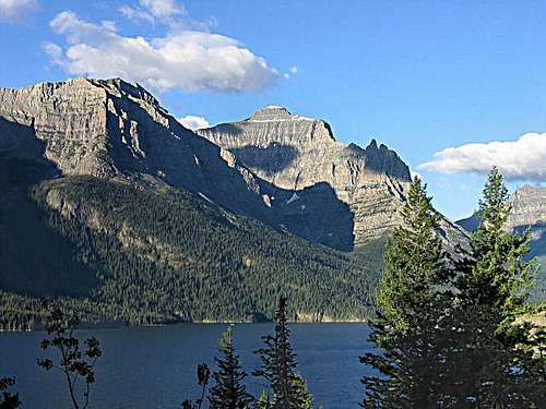
![Little Chief Mountain]() Little Chief Mountain
Little Chief MountainThe debate was over almost quicker than it had begun and I was hiking toward a peak that I really wanted to bag. By this time water was becoming a problem on the barren ridge top. As I dropped down toward the saddle between Mahtotopa and Little Chief, I heard and saw some water running on the south side of the slope and perhaps only two or three hundred vertical feet below my ideal route. This was good fortune for when I started drinking and refilling my water bottle, I accepted that dehydration had started to become a problem. After “cameling up” I continued without incident to the summit of Little Chief where the sun was decidedly starting to move lower in the west. This did not seem to be a problem since going down should proceed with decent speed and I expected to be back to the road and hitching a ride back to the car long before dark.
Anyone who takes a different route down from the one used to climb, will probably know there are unknowns lurking, especially where no trails exist. With anticipation of the nature of the cliffs to take away what you, moments earlier, thought you had, I started heading down and toward the south vaguely recalling bits and pieces of the route description I had read casually while thinking about a future climb. Before going very far, there was a great looking couloir heading down the west face and it had plenty of class 3 and easy class 4 moves which I carefully negotiated getting closer and closer to a scree slope that runs around the base of the cliffs and has a nice goat trail on top inviting you to partake. After a couple of increasingly difficult pitches, suddenly the remaining 150 feet became true vertical (sans holds) and there was no way to proceed short of a rappel. I studied this with a sinking feeling before making the only choice…climb back up about 800 feet. OK, I was tired, but this was just a minor setback…right? Of course. On reaching the top I noted the sun gaining momentum down and headed further south until a second really promising couloir appeared. With gradually building enthusiasm, I repeated my climbing moves from the previous hour and started to believe that this was the answer to my prayers as that goat path looked even better…and then…you probably already guessed, another vertical 100 feet or so of air separating me from the goat freeway.
Again, much furtive looking for an alternative, led to nothing but the need to start another unplanned climb and the sun was near the horizon. Did I mention that I was talking to myself and feeling rather tired by this point. It was looking like my first unplanned bivy in Glacier was about to unfold. On reaching the top of the couloir once more, I decided to head much further south and eventually spotted a slope that looked like it could be descended completely down to the trees. It did, in fact, and I was past the troublesome cliff band as darkness set in. It still was looking like a night in the park, but I could hear the falls and following the terrain down and toward the sound, I eventually stepped out on the trail not far from the falls. Of course, being Glacier, there was the ubiquitous bushwhacks along the way during which my safety was torn from my bear spray, but fortunately, not the canister from the holster which happened to me on Goat Haunt Mtn.
By the time I was at the trail, the moon had started adding lots of light and it seemed like the highway appeared in no time, although it was 9:15 pm. No problem…well, one small problem…the road was deserted. I’ve seen tens of thousands of cars going up and down this road over the years, but check it out late at night in late September after most of the tourists have gone home and the student employees of the park have gone back to campuses. There was a slight chill in the air and nothing really to do, but start hiking back down the road toward my car. This was probably the spookiest experience of my life…walking down a deserted road in the middle of Glacier late at night surrounded by who knows how many bears. Before long, I was carrying my bear spray in one hand my flashlight in my other and listening for the sound of a grizzly heading out of the woods to have me for a snack right on the centerline where I was walking.
As luck would have it, I probably only went about a mile or two when I heard the sound of a vehicle coming down from Logan Pass and soon saw headlights in the distance. Debating the merits of standing in the center of the road waving my arms or on the side of the road trying to look like a perfectly engaging hitchhiker, I chanced the latter approach and was elated when the car stopped for me. It was a couple of park employees who were heading back to college the next day and had done the hike from Logan Pass across the Sperry Glacier basin and down to the Lake McDonald lodge. They had left their car at the pass and found that getting a ride back had taken at least an hour of standing by the road before success. Thus, they were #1 - in sync with my schedule and #2 - attuned to my dilemma of needing a ride. They even took me right to my car rather than dropping me at the cutoff which I would have been more than happy with! I drove into St Mary and called home to explain that I was “safely out” and would be home in a couple of hours or sooner, if possible.
In talking to my friend, Ivan, the previous night about my proposed trip, wondering if it would be possible to get as far as Little Chief, and looking for any beta he might have, one great piece of advice had been given. “Take a flashlight”, he said, knowing my propensity for ad libbing. That has been a regular part of my pack ever since and has been useful on a number of occasions. It had been an epic trip and with the water call and the extra “yo – yo” climbs following the summit of Little Chief, I had climbed nearly 10,000 vertical feet for the day according to my altimeter logbook. For one of the few days in my life, I had not seen another human from sunup to sunset.


Comments
Post a Comment