
-
 15282 Hits
-
 78.08% Score
-
 9 Votes
|
|
Area/Range |
|---|---|
|
|
45.18851°N / 109.25592°W |
|
|
Aid Climbing |
|
|
Spring, Fall, Winter |
|
|
6000 ft / 1829 m |
|
|
Overview
Red Lodge, Montana is a quaint little town near the northeast entrance to Yellowstone National Park offering some fantastic ice climbing away from the crowds at Hyalite. Popular with Yellowstone tourists coming from the east coast, many visitors pass through in the summer heading over the Beartooth Pass and on their way to the geysers. However, Red Lodge offers many hidden secrets for those willing to do a little searching. The goal of this page is to describe all the ice climbs within an hour or so from the town and provide all ice climbers who desire a little solitude a chance to climb with the locals.
Being only 60 miles from Cody, the Red Lodge area gets overlooked all the time and although there isn't the same concentration of ice climbs like the ones up the South Fork of the Shoshoni River, there are more alpine-like climbs many of which guarantee solitude. I have ordered the routes from north to south starting in the Stillwater River valley, then to the Rosebud drainage system and ending with the Rock Creek forks. Heading each route description, I have the route name, followed by the grade and length of ice climbing in meters.
I will continue to add to this page as I do more routes around Red Lodge!
Stillwater River
Woodbine Falls - WI 3 100m
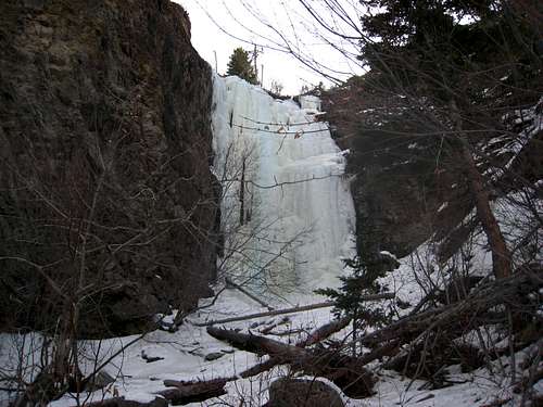
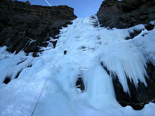
This flow has one of the shortest approaches and easily accessible all winter due to the Stillwater Mine. This was one of the first ice routes to be climbed in the area during the 1970's although with the improved crampon and ice tool technology, this climb is now a moderate classic. This waterfall is quite large so it's best climbed after a significant cold spell. From Red Lodge, drive north out of town on MT 78 and go 20 miles to Roscoe. Continue past Roscoe and go another 12 miles to the intersection with County Road 419 (towards Fishtail). Turn left (west) here and pass through Fishtail after 4 miles and continue all the way to the Stillwater Mine passing the Montana Jacks Bar and the town of Nye along the way. The mine will be on the right and about a half-mile further, just before the trailhead and the end of the road, is a turn-off to the left for the Woodbine Campground. Turn here and park at the gate since the campground is closed in winter.
Hike through the campground to the highest loop towards the left side and look for a foot bridge. This marks the start of the trail. Cross the bridge and hike 20-25 minutes along the mellow trail until you reach a deep chasm where the falls come into view. You cannot miss it! Descend 50 feet to the stream below and put the crampons on here.
The climb begins by hiking a couple minutes up the frozen stream and reaching the base of the long, but low angled first pitch. When fat, this 45 meter pitch is no harder than WI 2 and doesn't exceed 65 degrees. Of course, harder lines can be found towards the right side of the wide flow. There is a large tree to belay from atop the first pitch. A few minute hike gets you to the base of the WI 1+ second pitch which is usually soloed and only 15 meters high. Just above the second pitch is a large pool of water that must be hiked around on the left side to a large tree. The third pitch is a steep but short WI 3+ step that rarely forms. If it's formed, it makes for a beautiful 15 meter pitch of near vertical but very featured ice! Descend by walking off to the left and heading down the forested slope above the canyon where you'll meet the trail again.
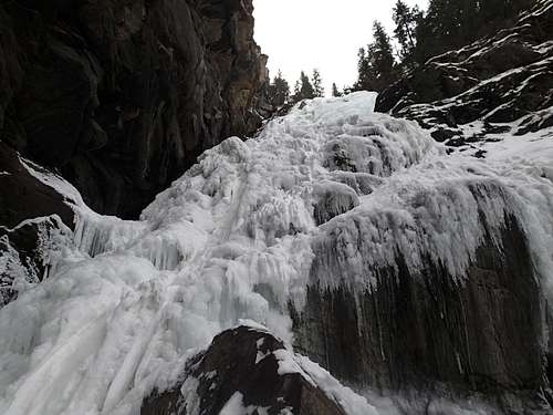 Looking up the first pitch of Woodbine Falls Looking up the first pitch of Woodbine Falls |
 Jacob leading the rarely formed third pitch of Woodbine Falls Jacob leading the rarely formed third pitch of Woodbine Falls |
 View of the third pitch of Woodbine Falls View of the third pitch of Woodbine Falls |
Other routes in the Stillwater drainage require a 2-5 mile hike or ski up the Stillwater River Trail from the trailhead and are rarely done.
West Rosebud River
All climbs in the West Rosebud drainage start from the trailhead at the end of the road (Mystic Lake Trailhead).
West Rosebud (Mystic Lake) Trailhead
The West Rosebud Trailhead is located approximately 80 miles southwest of Billings. To reach the trailhead, take the Columbus exit from Interstate 90, and take Montana Highway 78 through Absaroka and turn west (right) toward Fishtail (approximately 17 miles from Columbus). From Fishtail, drive west and south for 1 mile and turn south (left) on West Rosebud Road. Follow this paved road for 6.3 miles until reaching a fork in the road and a large brown Forest Service sign. The sign will indicate West Rosebud Lake Road #2072. Turn left here and follow the dirt road for 14.4 miles until reaching the trailhead. The trailhead has toilet facilities, and a large parking area. Please obey the posted private property signs and do not drive beyond the trailhead parking area. The trail actually begins up the road about 200 yards, and is reached by walking through the Montana Power Company facilities where the trailhead is clearly marked with a Forest Service sign.
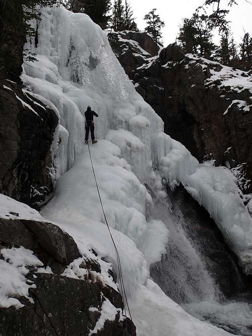
The Anti-Duct - WI 5 60m
Back in the day when the pipeline used to leak, there were scores of fantastic ice routes on the north side of the valley easily accessible from the West Rosebud trailhead. During this time, this area was probably the best kept secret in Montana! However, the pipe has since been fixed and ice climbing has been limited to the south side of the valley. The Anti-Duct is now likely the best route in this drainage and being north facing, forms early and lasts well into March.
Able to be seen from the parking area, hike up the main trail for 2 miles to the top of the switchbacks and just before reaching the exposed section of trail blasted out of the cliff, turn left and hike steeply up talus or snow to the base. Typically this climb is done in two pitches with the first pitch being WI 4 and ending in a cave with a piton belay station. The second pitch is WI 5 and heads up a steep curtain which may not completely reach the ground. Descend by either walking off to the left or rappel the route which is tricky due to the lack of anchor possibilities above the second pitch.
 Second pitch of Anti-Duct
The Spillway - WI 2/3 60m
This is probably the best place for beginners to go ice climbing in the Red Lodge Area. A long and fat, low angled flow offers great ice for beginners to get their first leads in. The setting is spectacular sitting literally right on top of the Mystic Lake dam. The best way to approach it is to continue along the main trail passing the Anti-Duct route and going all the way to Mystic Lake. Scramble down the right hand wall of the dam and rappel on trees to the base of the spillway. The approach takes the average party 2 hours to complete but Mystic Lake in winter is really a sight to see.
There are numerous lines on this very wide flow with the far right side being the easiest at WI 2. The middle and left range from WI 2 to WI 3. Finding a belay spot can be tricky...best to just make an anchor with screws. Descend by returning up to the top of the dam and following the trail back. Do not descend the valley floor as the creek would post serious issues if not frozen and the bushwhacking would be horrid.
East Rosebud River
The East Rosebud drainage is the most spectacular valley on the Beartooth front for many reasons. Huge big rock walls line both sides of the valley and offers endless rock climbing opportunities in the summer and plenty of ice routes in winter. All climbs are accessed by the East Rosebud Road.
EAST ROSEBUD TRAILHEAD
From the MT 308 and US 212 junction at the south end of Red Lodge, head north on US Highway 212 for 1.5 miles and turn left onto MT State Highway 78. After 19.7 miles reach Roscoe and make a sharp left onto East Rosebud Road and measure from this point. After 0.2 mile, pass by the Grizzly Bar and restaurant and continue another 2.4 miles where the road turns to gravel. At mile 3.7, make a left onto the East Rosebud Lake Road and quickly cross East Rosebud Creek on a bridge. Just after the crossing, make a right on East Rosebud Lake Road and cross a cattle guard. At mile 8.3 enter the Custer National Forest where the road becomes paved again and now becomes FS Road 2177. Pass the Jimmy Joe Campground at mile 11.9 where it turns to dirt once again. Pass the Phantom Creek trailhead at mile 13.6 and continue another 3/4 mile to the turnoff for the East Rosebud campground. Drive a short ways to the end of the campground and park at the signed trailhead which is at 6,400 feet elevation.
Winter maintenance of this road ends at the group of homes about a mile before the pavement starts again where it enters the Custer National Forest. This allows deep ruts to form making it unsuitable for passenger cars. Also, 4WD vehicles will not typically be able to get all the way to the road's end as deep snow drifts over the road right before the campground so an extra 1/4 mile of road walking is typically needed for any routes beyond East Rosebud Lake.
Small Falls (WI 4), Sand Dune Falls (WI 5), and Fire Killer (WI 3+) are all on the opposite (north) side of the river about where the road enters the national forest (beginning of pavement again). I haven't yet done them but I know that reaching these routes can involve private property issues, as well as the river being unfrozen. I will add information about these routes when I do them.
Hellroaring Falls - WI 4 30m
This flow also has an incredibly short approach and situated on a small cliff band close to the road. GO a half-mile past the start of the pavement upon entering the national forest, and park at a nice pull-out along the right side of the road just before a large beaver pond directly below the route. Walk up the small drainage for 15 minutes to the base. There are a number of options, all single pitch but the easiest line is on the right side offering nice climbing. Further left the ice is vertical offering one true WI 5 line. There is a tree at the top of the route you can use to set up a toprope on. You can also walk around and up to the right to reach the top without having to lead making this a perfect place to take friends and beginners.
 Approaching Hellroaring Falls
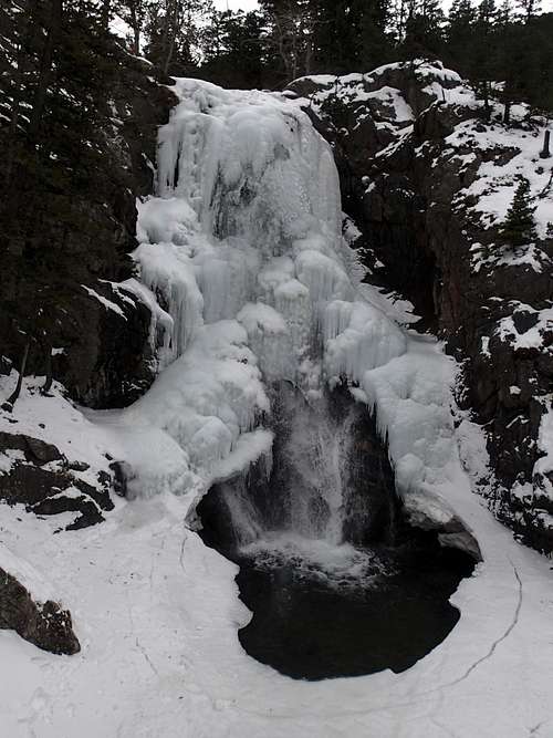
Upper Rosebud Falls - WI 4 55m
This is a nice route situated just beyond the end of the road and above the south end of East Rosebud Lake. If possible, drive all the way to the trailhead, otherwise park where the drifts start and hike the 1/4 mile of road to the trailhead. Begin hiking up the trail as it heads behind the fancy summer homes along the shore of East Rosebud Lake. Continue past the final house and reach "The Hump" about a mile from the trailhead. This feature is a section of trail blasted out of a cliff band and descending 40 feet to the river right where it dumps into the lake. Do not descend down past The Hump but instead leave the trail and ascend gently leftward to the top of the rocky slabs right above you. The route will clearly be seen to the left in the first major gully. Hike up the gully on talus for 500 vertical to the base of the route.
There are many lines to choose from ranging from WI 3+ to WI 5 on this single pitch flow. Beware this route is typically very windy. Descend by rappelling the route using a V-thread.
 Upper Rosebud Falls
California Ice - WI 4 100-2000m
See the page I made describing this classic route Here. This is probably the best ice climb in the Red Lodge area and one of the best moderate ice climbs in the state!
 Jacob leading the first pitch of California Ice
Rock Creek Forks
There are a handful of nice ice flows scattered throughout the three Rock Creek forks most of which have longer approaches and have a more alpine feel. There are three different trailheads depending on which fork you are heading up. The West Fork heads west right out of Red Lodge. The Lake Fork heads west about 8 miles out of town to the south on Highway 212 and the Main Fork roads leaves Highway 212, 11 miles out of town. All these roads are not plowed and gated in winter making the ice in the Rock Creek area best climbed in early season, typically from mid-October through November. Otherwise you'll need either a snowmobile or a pair of skis and a very strong will.
WEST FORK ROCK CREEK
From the center of Red Lodge at the MT 308 and US 212 junction, head west 0.3 miles on US 212 and turn right onto the West Fork Road with signs for the Red Lodge ski area and measure distances from this turnoff. The road immediately comes to a Y, stay left and head up the paved road passing the Palisades Campground Road (gravel) on the right after 1.1 miles. Continue and enter the Custer National Forest after 2.8 miles and turn left to stay on the West Fork Road at 2.9 miles. Taking a right at this turnoff takes you to the ski area. Pass the winter closure gate at 5.2 miles, the Basin Lake Campground at 7.2 miles and the road turns to gravel at 7.4 miles. At mile 10.5, pass the Cascade Campground and reach the trailhead at mile 13 with an elevation of 7,890 feet. Here there is room for about 40 cars and 7 horse trailers and a pit toilet is available.
Horseshoe Falls - WI 3/4 45m
A nice rocky alcove gives this flow its name. Drive all the way to the to the West Fork of Rock Creek trailhead and hike up the trail for about a mile and look left across the valley for three flows sitting side by side. Cross the creek (hopefully frozen) and pick your way through downed timber and up to the base. This single pitch route offers many variations with any steep sections being short. Descend by rappelling on one of the trees above the route.
MAIN FORK ROCK CREEK
From the Montana Road 308 and US Highway 212 junction in Red Lodge, go west on US 212 for 11.4 miles and turn right onto FS 2421 (Rock Creek Road) and measure from this point. Follow this paved road for 0.9 miles where it turns to dirt and passing by three National Forest campgrounds. Here the road forks, take the left fork and continue on the good dirt road and pass the M-K Campground at mile 2.8. Here the road becomes rougher. Continue 8 miles on this road as it drops into Wyoming and reaches the trailhead at the Montana/Wyoming state boundary at 8,700 feet. This road is passable for tough passenger cars with good ground clearance. There are many good places to pull off and camp on either side of the road.
Rock Creek Falls - WI 2+/3 35m
This flow offers a nice easy climb on the south side of Highway 212 about 600 feet above the valley floor. Park at the junction where the Main Fork road veers right off the highway, 11.4 miles from Red Lodge. Walk a few minutes down the road and look for the footprints leading south into the trees. This is a popular route making the approach nearly always trampled out. Hike through sparse trees and angle slightly left until you hit a cut line in the trees heading straight up the gentle slopes. Follow this "trail" up until you ca see the main gully just to the left. Enter the wide gully and follow it up to the base of the route. In early season this gully is filled with ice covered boulders and talus making for a horrid approach. Allow 1 hour to reach the base.
There is a 15 foot WI 2 step most people solo to get to the base of the main flow. If there is enough snow you can also avoid this first step on the left. The single pitch main flow is about 20 meters long and pretty easy, reaching an angle of only 65-70 degrees. At the top, you can walk left to a tree with plenty of slings around it or try and find the bolts that are probably buried. Descend by rappelling off the big tree.
Hidden Falls (WI 4), and Funeral For a Friend (WI 4+) are up the Main Fork road a considerable distance and are only doable in early season. I have not yet done them but will add information when I do.
Ice Climbing Gear
Nearly every route described here requires double 60 meter ropes, so have them! In addition to the obvious gear like a set of 10 screws, ice tools, crampons and warm clothes...also have plenty of 5-6 mm cord to make anchors with. Also make sure you have a V-thread tool as many routes require rappelling on a V-thread. Always wear a helmet when ice climbing and consider using screamers. Ice climbing is much more dangerous than rock climbing so do not attempt to lead well beyond your limit.