
-
 89033 Hits
-
 94.63% Score
-
 48 Votes
|
|
Area/Range |
|---|---|
|
|
45.14330°N / 109.69849°W |
|
|
Hiking, Mountaineering, Trad Climbing, Mixed, Scrambling, Skiing |
|
|
Spring, Summer, Fall, Winter |
|
|
Overview
 Granite Peak
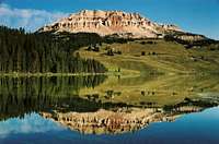 Beartooth Butte
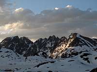 Sawtooth Traverse
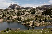 Beartooth High Lakes
 Medicine Mountain
 Black Canyon Lake
 Mystic Lake
 West Rosebud Valley
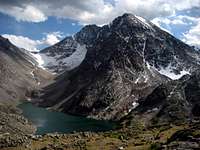
The Beartooth range is a spectacular alpine mountain range that sits in south central Montana just west of the small town of Red Lodge and northeast of Yellowstone National Park. The Beartooth Mountain range was named after its namesake Beartooth Mountain and is known for a number of things besides its size and remote lakes. It is the range where all of Montana's 26 (or 27) 12,000 ft peaks exist. For a list of these peaks see this page.
Approximately 25 small glaciers exist in the Beartooths with Grasshopper Glacier being one of the more unique. The Beartooth Mountains are home to Granite Peak (12,799), the states highest point. Granite peak is known for its class 3/4 terrain and difficulty rating among other state highpoints. From Livingston, Montana the Beartooth Mountains are bordered by Red Lodge on the east, the Yellowstone River on the west and south, and the Clarks Fork of the Yellowstone in the southeast. The Beartooth Mountains are part of the greater Absaroka-Beartooth Wilderness. The Absaroka-Beartooth (AB) Wilderness was designated in 1978 by the United States Congress. The Beartooth Primitive Area (225 Thousand acres) and the Absaroka Primitive Area (64 Thousand acres) plus a considerable amount of additional wilderness surrounding these two areas now form the AB Wilderness. The primitive areas were originally set aside during 1932 to protect their natural state. The AB Wilderness currently managed by the US Forest Service and is one of the best wild and untouched areas in the continuous United States.
The Beartooths are composed of granite and crystalline metamorphic rocks and are some of the oldest rocks on the continent. They are the location of the largest known deposits of platinum and chrome and the second largest deposits of nickel found in the US. Just north of the mountain core is the Stillwater Mine where a very rich deposit of nickel and chrome is currently being mined. All the deep valleys throughout the range were carved out by glaciers during the last ice age. Prior to this the Beartooth Plateau was one very massive uplift of core granitic and metamorphic rock that was nothing more than a very gentle round blob of rock that became exposed at the surface after sediments lying above eroded away. Without the work of glaciers the Beartooth Mountains would be a very boring place sitting high in elevation.
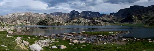
The region is also one of the few areas left with sizable populations of grizzly bears outside of Alaska and Canada. Black bears, mountain goats, bighorn sheep, elk, moose, wolverine, mountain lion and lynx are also found here. Primarily plants and grasses exist above the 9,000 foot (2,700 m) timberline and spruce, fir, whitebark pine and lodgepole pine are found below. The Beartooths are well known for their 300+ alpine lakes rich in trout. Brook Trout are an invasive species with the Yellowstone Cutthroat being native. Many of these high alpine lakes are very large and offer some of the best scenery and backcountry camping you can imagine.
The Boulder River begins in the AB Wilderness, and flows north where it merges with the Yellowstone in Big Timber. The Boulder River provides fishing as well as river side camping sites in the Gallatin National Forest. It winds its ways through valleys and over waterfalls creating stunning and scenic backdrops. It is a great river for a weekend of camping and fly fishing. The vastness of the wilderness area and remoteness of its peaks makes the Beartooths an excellent range for backcountry travel and climbing. There are a number of ranch style resorts peppered throughout the range providing horse back riding, Christian retreats and fishing. If scenic vistas with ease of access interest you, the Beartooth Scenic Byway is where you need to go. Start your journey on Highway 212 at the border of Custer National Forest in Red Lodge Montana. You'll have the ultimate high-country experience as you wind through the Custer, Shoshone, and Gallatin National Forests to the byway's end near the northeast entrance to Yellowstone National Park. You'll see rugged mountains, icy glaciers, and alpine meadows full of wildflowers. No doubt you will see plenty of marmots.
Getting There
 Second Rock Lake
 Shadow Lake
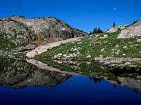 Crystal Lake
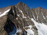 Granite Peak
 Varve Lake
 Bears Tooth
 Sky Pilot Mountin
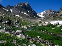 Spirit Mountin
 Forget Me Not Mountin
 Whitetail Peak
 Froze-to-Death Lake
 Spirit Mountain
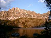 Mount Wood from Lake Wilderness
 Mount Wood from Stillwater Plateau
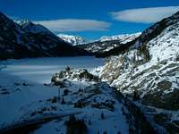 Mystic Lake in Winter
 Wood-Hague Traverse
Hiking and climbing throughout the Beartooths is seemingly endless in opportunity. Here I will describe all the major trailheads and what the highlights are from each one.
West Fork Rock Creek Trailhead Access to the Whitetail Group and Castle Mountain - This is one of the more popular trailheads in the Beartooth Mountains and offers fantastic scenery. From the center of Red Lodge at the MT 308 and US 212 junction, head west 0.3 miles on US 212 and turn right onto the West Fork Road with signs for the Red Lodge ski area and measure distances from this turnoff. The road immediately comes to a Y, stay left and head up the paved road passing the Palisades Campground Road (gravel) on the right after 1.1 miles. Continue and enter the Custer National Forest after 2.8 miles and turn left to stay on the West Fork Road at 2.9 miles. Taking a right at this turnoff takes you to the ski area. Pass the winter closure gate at 5.2 miles, the Basin Lake Campground at 7.2 miles and the road turns to gravel at 7.4 miles. At mile 10.5, pass the Cascade Campground and reach the trailhead at mile 13 with an elevation of 7,890 feet. Here there is room for about 40 cars and 7 horse trailers and a pit toilet is available.
Lake Fork Rock Creek Trailhead Access to Beartooth Mountain and the Rock Lakes - From the Montana State 308 and US Highway 212 junction in Red Lodge, go 10.8 miles west on US 212 towards Beartooth Pass and turn right onto the Lake Fork Road. Go 1.8 miles on this paved road to its end at the trailhead with ample parking. The elevation at this trailhead is 7200 feet.
Main Fork Rock Creek Trailhead Access to the Spirit Mountain Group and Glacier Lake - From the Montana Road 308 and US Highway 212 junction in Red Lodge, go west on US 212 for 11.4 miles and turn right onto FS 2421 (Rock Creek Road) and measure from this point. Follow this paved road for 0.9 miles where it turns to dirt and passing by three National Forest campgrounds. Here the road forks, take the left fork and continue on the good dirt and pass the M-K Campground at mile 2.8. Here the road becomes rougher. Continue 8 miles on this road as it drops into Wyoming and reaches the trailhead at the Montana/Wyoming state boundary at 8,700 feet. This road is passable for tough passenger cars with good ground clearance. There are many good places to pull off and camp.
East Rosebud/Phantom Creek Trailhead Access to the Mount Peal group, Rainbow Lake and Whirlpool Creek - From the MT 308/US 212 junction in Red Lodge, go north on US Highway 212 for 1.5 miles to the junction with MT 78 and turn left (west). Continue on this road 20 miles to the small town of Roscoe. Drive through the tiny town which is home to the Grizzly Bar and Grill (great food). Turn left on the East Rosebud Road and measure from this point. At 2.6 miles the road turns to dirt. Cross East Rosebud Creek at mile 3.7 on a nice bridge and immediately past the bridge turn right to stay on East Rosebud Road and cross a cattle guard. At mile 8.3 enter the Custer National Forest where the road becomes paved once again and it turns into FS 2177. Pass by the Jimmy Joe Campground at mile 10.3 and continue to mile 11.9 here the road becomes dirt again. At mile 13.6, turn right at the Phantom Creek Trailhead pullout and park. There is room for about 8 cars and sits at an elevation of 6,200 feet. For the East Rosebud Creek Trailhead, continue another 0.9 mile to the end of the road at a large parking area. Just after crossing the creek next to East Rosebud Lake, stay left and avoid driving down the private road.
West Rosebud Creek Trailhead Access to the Granite Peak group, Mount Wood Group and Mystic Lake - The West Rosebud Trailhead is located approximately 80 miles southwest of Billings. To reach the trailhead, take the Columbus exit from Interstate 90, and take Montana Highway 78 through Absaroka and turn west (right) toward Fishtail (approximately 17 miles from Columbus). From Fishtail, drive west and south for 1 mile and turn south (left) on West Rosebud Road. Follow this paved road for 6.3 miles until reaching a fork in the road and a large brown Forest Service sign. The sign will indicate West Rosebud Lake Road #2072. Turn left here and follow the dirt road for 14.4 miles until reaching the trailhead. The trailhead has toilet facilities, and a large parking area. Please obey the posted private property signs and do not drive beyond the trailhead parking area.
Beartooth Lake Trailhead Access to Beartooth High Lakes, Castle Rock group and Snowbank Mountain - From the MT 308 and US 212 junction in Red Lodge, head west on US 212 for 40.5 miles to the Beartooth Lake turnoff on the right. Measure from here and take this gravel road and stay straight after 0.3 mile and pass by the boat launch. At mile 0.6 turn left into the trailhead marked with a sign. There is room for just a few cars here.
Clay Butte Trailhead Access to Beartooth High Lakes, Castle Rock group and Snowbank Mountain - From the Beartooth Lake turnoff (see above), continue west on US 212 for 1.5 miles and turn right on the well maintained Clay Butte Road. Continue another 1.5 miles to the trailhead (elevation 9,580 feet) on the left side of the road right before a hairpin switchback.
Aero Lakes Trailhead (Lower) Access to the Villard group, Granite Peak and Aero Lakes - Starting from Cooke City Montana, head east on US 212 for 1.6 miles to the signed turnoff for Lulu Pass. Turn north on this good gravel road and measure from this point. Follow it for 1.1 miles to a 3 way fork and continue up the middle fork. Stay right at 1.8 miles and reach the signed Goose Lake Junction after 2.4 miles. It is best to park low clearance passenger cars here off the road. There is a very large open area surrounding this large junction. If you have a higher clearance tough car or a 4 wheel drive vehicle, you can continue further. From the Goose Lake Junction make a sharp right turn on a small side road (don’t continue to Lulu Pass or Goose Lake). Follow this rough and highly rutted side road for 0.3 mile to the trailhead at 8,850 feet in elevation where the road ends. A very old mining shed and minding junk can be found here so be careful where you drive and park and watch for sharp objects just waiting to eat your tires!
Aero Lakes Trailhead (Upper) Access to the Villard group, Granite Peak and Aero Lakes - If you have a high clearance 4 wheel drive vehicle, you can continue to the upper trailhead. From the signed Goose Lake Junction, continue up the rough road towards Goose Lake. Pass by Mud Lake and continue 0.3 mile past Round Lake to the trailhead just off the road at 9,420 feet in elevation. A trail descends about 500 feet to the main Aero Lakes trail from here.
Golf Course (Benbow) Trailhead Access to the Mount Wood Group - This trailhead is unmarked and difficult to get to. A tough passenger car can make to the Benbow Mine but a high clearance vehicle is advised. In the "Hiking the Absaroka-Beartooth Wilderness" Falcon Guide book, this trailhead is called the Lake Wilderness trailhead. Information about getting here can be found on page 97 of this book. In short, if coming from Red Lodge, start from the MT 308 and US 212 junction at the south end of town and drive north on US 212 for 1.5 miles and turn left onto MT 78. Continue on this road west for 30 miles and turn left on CO Road 419 (also called Nye Road) and continue on this road for 14 miles passing through the small town of Fishtail on the way. Just past the Montana Jacks Bar and Grill in the tiny town of Dean, turn left (south) onto Benbow Road (FS 1414). Drive this very windy road as it switchbacks up to the Benbow Mine tower after 11.4 miles at an elevation of 8,480 feet. Park passenger cars here. 4WD vehicles can continue driving up a series of switchbacks an additional 2 miles up to and across a large open meadow land known as the Golf Course (apparently some miner thought it looked like a golf course). The trailhead it at the south end of this large field at an elevation of 9,100 feet where the road narrows into a trail. This trailhead is used for climbing Mount Wood and Mount Hague from the north approaching across the Stillwater Plateau.
Classic Climbs and Trails
By no means is this list exhaustive! This area if full of opportunities for exploration.
 Whitetail Couloir
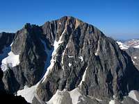 Beckey Couloir
 Spirit Mountain NE Couloir Mount Wood North Face
 Castle NE Couloir
 Mount Peal E slopes
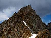 Granite Peak E Ridge
 Silver Pillar on Silver Run Peak
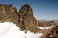 Castle Rock Spire
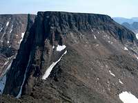 W Ridge of Point 12,540
 View from Sundance Pass
 Moon Lake
 Lonesome Mountain
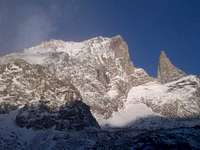 Beartooth Mountain and Tooth
 Part of the Mystic Traverse
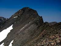 Castle Rock Traverse
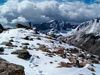 Whitetail Peak NE Ridge
 The Sundance Traverse
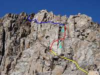 Granite Peak Standard E Ridge
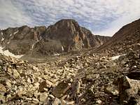 Granite Peak South Face
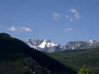 Mount Wood from Dean, MT
 Mount Wood from Granite Peak
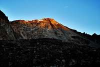 Mount Hague
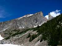 Bears Tooth
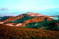 Mount Rearguard Alpenglow
 Mount Rearguard summit towers
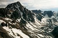
The Beartooth Mountains are loaded with great climbing opportunities ranging from easy scrambles to multiple pitch fifth class rock climbing. However what this range might possibly be best known for is the snow climbing in late spring and early summer. In no particular order, I will briefly describe some of the classic climbs of the Beartooth Mountains and some of the more scenic trails for those who are less inclined to push the envelope.
Snow Climbs
Whitetail Couloir on Whitetail Peak This has to be the most well known snow climb in all of Montana and certainly a classic. This fantastic line zooms directly up the north face of the mountain and starts out slightly below 45 degrees but becomes sustained 50 degree snow for over 800 feet. A loose third class escape is available to climbers left halfway up is things go wrong or conditions deteriorate on the way up. This climb is best done in late June to early July and is best protected with a handful of pickets. This couloir has been skid amazingly.
Granite Peak Southwest Couloir This is one of the lesser known lines but offers a great way up the states' highest peak from the south. Averaging 45 degrees this snow climb is a great way to avoid the crowds on Granite Peak and offers a more scenic approach via Aero Lakes. Due to the south facing nature of the couloir it is best climbed in early June before it melts away at which point the route is best avoided.
Beckey Couloir on Glacier Peak This route is for the experts only. Thousands of feet of snow and ice nearing 60 degrees lead straight up the north face of Glacier Peak. Once near the top of the couloir, 5-7 rock pitches up to 5.7 climbing is required to gain the summit. Not only is the climb hard but the approach can also be a pain. Views of this route from Granite Peak West are superb.
Spirit Mountain Northeast Couloir (Dark Moon Couloir) This line has been climbed only a few times with the first ascent by Loren Rausch. This line appears to slightly exceed 50 degrees in steepness and follows a direct but narrow line directly to the summit plateau. Best approach is via Moon Lake and is best climbed in June to middle of July. Views of this line from Mount Rearguard are amazing.
Mount Wood North Face This climb is an all around pain, except for the north face part which has about 1000 feet of 45 degree snow. Getting to the base of the snow climb involves either a long walk over the Stillwater Plateau followed by a loose crappy descent on talus to the small glacier to the east or a bushwhack up the West Fishtail Creek from Chrome Lake. Climbing the snow is nice and once at the top, an easy scramble leads to either summit.
Castle Mountain Northeast Couloir This route sits in a spectacular alpine setting. Approach via West Fork Rock Creek and hike all the way to the head of the valley. Of the two lines easily seen on the east face, aim for the couloir further north (climbers right). It averages 45 degrees and has a large schrund near the base that adds a little spice to the climb. Climbers have reported climbing down and back up through it, bypassing it on rock or crossing a nice bridge.
East Slopes of Mount Peal This snow route is less steep than most. It is best done in June before the area surrounding Froze-to-Death Lake completely melts out. Otherwise this area becomes lots of knee-jerking talus hopping. Approach via Phantom Lake and climb the moderate 35 degree snow slopes to the summit.
Rock Climbs
East Ridge of the Bears Tooth It doesn't get much better than this. Approach via the Lake Fork Rock Creek and Black Canyon Lake. From the canyon upstream of Black Canyon Lake, ascend steep and loose slopes into the amphitheater below the large east wall of Beartooth Mountain. Scramble diagonally from lower left to upper right over exposed and slick slabs covered with ball bearing scree. The east ridge starts by traversing a large down sloping ledge across the base of the Bears Tooth to the East Ridge. The first three pitches are moderate 5.6 climbing with excellent pin belay anchors at each pitch. The final, 4th pitch runs at 5.8 and the route is rappelled.
Granite Peak East Ridge This is the standard route on the states' highest peak. Rated 4th class this is often regarded at the most technical state highpoint besides Denali. There are many ways to approach it but the two most popular are Froze-to-Death Plateau and the Avalanche Lake/Mystic Lake. Once at the saddle between Granite Peak and Tempest Mountain, follow a boot path to the "snow bridge" which is basically a cornice crossing at the top of the Southeast Couloir. Just beyond this snow crossing the first 4th class chimney is climbed. Continue following cairns up alternating 3rd class ledges and 4th class chimneys to the summit.
Silver Pillar on Silver Run Peak This big wall climb is no joke. At the head of Timberline Creek beyond Timberline Lake lies a very prominent pillar looking wall. 900 feet of 5.10 climbing with a little aid climbing is needed to climb this wall. It was first climbed by Jim Kanzler and Chad Chadwick in the early 1970's.
Castle Rock Spire This slightly easier rock climb leads to a beautiful perch between Castle Mountain and Point 12,540. If only it were slightly higher it would have enough prominence to be a ranked 12er but alas, it is only sought by the hearty alpine rock climbers. Approach via West Fork Rock Creek and Omega Pass or the Beartooth High Lakes Trail and Crystal/Flat Rock and Varve Lakes. Make an ascending traverse to the notch just west of the spire from east to west across the south face on mainly third and forth class rock with a couple 5.5 moves. Cut back to the right and continue on an ascending traverse following the easiest route to the base of a 5.6 chimney that leads to the summit. Getting to the spire is well over half the effort.
West Ridge of Point 12,540 This little known summit sits just west of Castle Rock Spire and lies only 40 feet higher. It is one of the ranked 12ers. Although it does have a flat summit area, getting here is one real treat. Approach the same way you would for Castle Rock Spire but instead continue past Varve Lake and Navajo Tarn to the west side of Point 12,540 and reach the saddle between it and Castle Rock Mountain. Climb the west ridge locating a couple key 4th class chimneys just south of the ridge crest and an important ledge leading to the summit area.
Scrambles
Southwest Ridge on Beartooth Mountain This route puts you way out there and gets you a true wilderness feeling. Approach via the tedious Black Canyon Lake and continue up the valley on either rough talus or snow. It is recommended this route be done when the long valley above Black Canyon Lake is still snow covered. Climb moderate snow to the saddle between Forget Me Not and Beartooth Mountains and climb over the flat false summit of Beartooth, then traverse the third class SW ridge. The final bit is a walk across the plateau to the east end.
Whitetail Peak Northeast Ridge This quaint little route starts from Sundance Pass and heads up the northeast ridge over talus and an occasional section of class 2+ scramble to reach the summit of Whitetail. This is the standard descent route for climbers doing the Couloir.
Traverses
Granite Traverse This is only done from west to east and is likely the best 12er ridge traverse in Montana, as it traverses the two highest peaks in the state. From Granite Peak, descend class 3 and 4 rock westward. This descent is loose and difficult so use caution. Once at the big drop off above the notch, rappel into the saddle which is the top of the notch couloir. This can be done with a 70 meter rope, harnesses and belay devices. Have extra webbing just in case. From the low saddle, climb up to Granite Peak via a class 5.4 chimney for one long 70 meter pitch, followed by class 3 and 4 scrambling to the summit.
Mystic Traverse This long 2.5 mile traverse circles the Storm Lakes Basin and traverses from Mystic Mountain to Granite Peak West. From Mystic Mountain, descend southeast towards Unnamed Point 11,908 and ascend this peak up some easy class 3 blocks which separate the two 12ers. From the top of Point 11,908 drop right on the south side of the ridge and traverse below the crest on small ledges and cross a couple ribs reaching the next low saddle. This section is the hardest with more sustained third class. Bypass a small peak to the left on a talus slope making an ascending traverse. Continue on or near the ridge and reach the upper west slopes of Granite West and reaching the summit. Plan on this taking 2 hours one way.
Castle Rock Traverse This traverse starts at Point 12,540. Descend your ascent route (West Ridge mentioned above) and hike the easy class 2 ridge to Castle Rock Mountain. Then continue on the easy ridge to Darlene Mountain. Don't forget to add in the third class ridge traverse to Point 12,090 from Castle Rock Mountain on your way. This is also a ranked 12er and these 4 peaks make a great long day from a camp at Flat Rock or Crystal Lakes.
Sundance Traverse This traverse connects Bowback and Sundance Mountains. From Bowback, descend south and drop down the right side of the ridge crest on a loose gully and traverse more or less horizontally below the towers (Class 3). When the terrain eases, return to the crest and reach the low saddle after a second small class 3 move. Ascend the other side, cross below a small cliff and up a gully to reach the Sundance Mountain summit plateau. Walk forever to the highest point.
Trails
Sundance Pass Far and away one of the best trails in the Beartooths is the West Fork Rock Creek Trail to Sundance Pass. Views from this pass are the best it gets for trails in the range. Views of the Whitetail Couloir, Castle Mountain and Beartooth Mountain are spectacular.
Shelf and Moon Lakes This short but steep trail takes you to two beautiful alpine lakes with fantastic fishing. Start from the Main Fork Rock Creek Trailhead and begin up the switchbacks. Locate a side trail heading right (north) just after the bridge and follow it to Shelf Lake. Continuing on the main trail leads to the over crowded Glacier Lake.
Beartooth High Lakes Trail This long trail climbs gently up the Beartooth Plateau from either the Clay Butte or Beartooth Lake Trailheads. It is popular with horses but passes by at least 15 large alpine lakes all having great camping and fishing. The trail ends shortly past Wright and Martin Lakes but taking a short cross country walk to Crystal Lake is well worth it.
Seasonal Considerations
 Winter Conditions
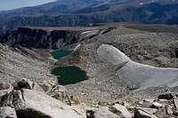 Summer Conditions
 Spring Conditions
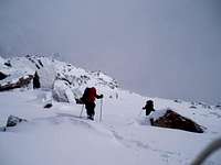 More Winter Conditions
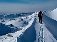
Spring - Spring travel in the Beartooths requires knowledge of the forest service roads and winter gear due to the nature of weather that occurs April - June. It is common to have temperatures in the 70's during the day and freezing temperatures or snow at night. Lingering snow from the winter always makes for difficult travel however this is typically the better time for ski tours and snow climbing in the many great couloirs available in the range.
Summer - Fall - Summer and Fall are the ideal times to hike and climb in the Beartooths. All of the Forest service roads are available by this time making many of the more remote areas accessible. The summer is categorized by cool nights and hot summer days where mosquitos and flies are thick. There have been early summer snowfalls on higher plateaus but proper planning can mitigate rough weather. Due to the nature of the area, thunderstorms and lightning should always be a concern during the summer. A good plan is to make sure you summit and are back down off the high peaks and plateaus by early afternoon. This area does get lots of rain especially in June and July so always come prepared.
Winter - Winter climbing in the Beartooths will require proper planning. Most of the forest service roads are closed during the winter leaving many peaks out of range for anything but the most extreme climbers. The weather in winter can be foul with blinding snowstorms, mixed rain and snow and high wind speeds. Winter camping can be fun on the Plateau's that the Beartooths are well known for provided you create protection for the high winds that often exist in these unprotected areas. Appropriate avalanche safety knowledge is a must when attempting these peaks due to the heavy snowfall and often unstable snowpack.
Overview Map
Shown below is an overview map of the Beartooth Mountains. Feel free to scroll around and change the display type at the upper right corner.
Red Tape
The great thing about the Beartooth Mountains is that it all lies within the AB Wilderness meaning there are no fees to enter. Please practice leave no trace techniques and if you have a campfire in the backcountry be sure you are following any burn ban restrictions. Fishing is very good in the Beartooth Mountain Lakes but you must obtain a Montana State Fishing License which costs $70 for out of state visitors and can be obtained at the hardware store in Red Lodge. Keep in mind you will also need one for Wyoming for fishing in the lakes south of the state line. No motorized travel or bikes in the wilderness. Make sure you always carry bear protection and if you see a bear, give it plenty of distance. Hang your food every night and avoid them at all costs if possible. If you injure or kill a bear for self defense make sure to report it to a ranger.
Links for More Information
 Castle Group Panorama
Custer National Forest Campgrounds
Red Lodge current weather forecast
Granite Peak current weather forecast
craighall - May 23, 2016 11:38 pm - Hasn't voted
Granite TraverseThanks for all the beta, guys. Granite Peak Traverse seems goofy though. Don't you mean "from West Granite Peak, descend southeast toward Granite Peak" ?
Matt Lemke - May 23, 2016 11:42 pm - Hasn't voted
Re: Granite TraverseYes... My apologies for the confusion
RenoGregory - Apr 4, 2017 12:04 am - Hasn't voted
I'm Going to Cryat how beautiful this mountain range is. I can't take it.