
-
 3940 Hits
-
 71.06% Score
-
 1 Votes
|
|
Route |
|---|---|
|
|
36.78400°N / 118.583°W |
|
|
Technical rock ( Big Wall ) |
|
|
One to two days |
|
|
V, 5.10, A3 |
|
|
Approach
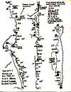
From the end of the Hwy 180, follow the trail west along the Kings River to the bridge crossing below the Grand Sentinel. Wander up talus and into the gully that runs under the North Face ( the D. O. A. gully ). See approach topo.
Route Description
Start at a steep " ramp " below the giant 800' green open book that forms the upper half of the route. Seven pitches ( 5.9, A1 or 5.10c ) lead to the base of the giant open book. Six pitches of devious difficult and sometimes dirty mixed free and aid climbing lead up the dihedral. Three easier pitches left of the corner lead to the top. See topo ( in photos ). Also see Summit magazine May / June 1986, Volume 32, Number 3.
 |  |  |  |
Essential Gear
In 1985 we used the following - 2 knife blades, 8 Lost Arrows, 4 Bugaboos, 2 each baby angles, 4 each angles 3/4" - 1", 5 - 1 1/4" angles, 3 - 1 1/2" angles, 1 each 2" - 4", 2 sets Friends and 15 stoppers ( mostly medium ). I'm sure many angles could be subsituted with cams etc today. However, when we did this route the Ranger said he hadn't seen anyone climb it in 8 years. So be prepared for what may appear to be a climb nobody has ever done! Check with the Cedar Grove Ranger Station for the latest route information.
Miscellaneous Info
If you have information about this route that doesn't pertain to any of the other sections, please add it here.