
-
 3959 Hits
-
 72.08% Score
-
 2 Votes
|
|
Route |
|---|---|
|
|
28.47350°N / 17.8513°W |
|
|
Hike and Scramble |
|
|
Less than two hours |
|
|
Walk-Down |
|
|
Approach
You reach the trailhead near the Volcán San Antonio Visitor's Centre from the town of Los Canarios by a side road fromn the town centre.Route Description
- Start altitude: 600m
- Summit altitude: 437m
- Prevailing exposition: W, later N
- Type: 2h along well marked trails
- Protection: marked
Actually this is rather a downhike than an ascent since the trailhead is located way above the destination. Still this is the usual route to the Teneguía Summit and it shows some great scenic views.
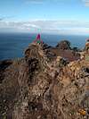
From the parking lot mnear the Volcán San Antonio Visitors Centre follow the trail, which is marked GR 131 - Ruta de los Volcanes. It steeply descends the slopes of San Martín to reach a forest road after 15min. Follow this road for another 15min and you'll reach Roque Teneguía, an volcanic outcrop above the western coast of La Palma. This Rock has some Rock drawings carved into its northern side, a leftover of the original La Palma inhabitants. Leave the route to head for Roque Teneguía. The trail first leads to a side crater of San Antonio before turning north for the Roque.
The trail passes Roque Teneguía to its southern side and descends to an irrigation channel which it follows southward in the direction of Teneguía. It reaches a water reservoir where you descend from the irrigation channel to a maintenance road which you follow for a couple of hundred meters. It leads to a "parking lot" (only to be used by all wheel drive vehicles) where the final ascent to Teneguía starts.
First you head directly for the northern crater but aim for its eastern side. There after some scrambling you get to the crater ridge which you follow to the summit. Though from afar an obvious trail, from nearby it is hard to be found. There are several possible routes along the crater ridge and I'm not sure we picked the best one. We climbed on the inside of the ridge but the better trail seems to be on the outside (?!?).
Near the northern summit the trail gets a little exposed as you negotiate the ridge between northern and southern crater, which is a knife-edge. Between northern and southern summit the trail is obvious and rather broad. Only in gale conditions like we encountered them it can get very dangerous.
 |  |  |  |