
-
 17435 Hits
-
 88.61% Score
-
 27 Votes
|
|
Mountain/Rock |
|---|---|
|
|
28.47350°N / 17.8513°W |
|
|
Hiking |
|
|
Spring, Summer, Fall, Winter |
|
|
1433 ft / 437 m |
|
|
Overview
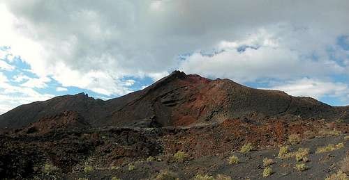 Volcan Teneguia as seen from the east Volcan Teneguia as seen from the east |
La Palma, Island of so many attributes: Isla Bonita, Isla Corazon, Isla Verde. It is arguably the most beautiful of the Canarian Islands but definitely the best hiking ground of all. Like the other six islands La Palma is of volcanic origin and here you can see and sometimes smell the volcanic activity. With approximately 2 million years of age the island is among the youngest of the Canarias, compared to Fuerteventura or Lanzarote which are about 25 million years old. Consequently La Palma is among the most active islands and in fact the last eruption to take place in the Canarias occured here, on Volcán Teneguía.
Compared with the highest summits of the Islands Teneguía is a real dwarf. With 437m it is barely visible from most of the island but still this is one of the most impressive sights the island has to offer. The volcano is located at the southern tip of La Palma a good indication for the fact that for the last millennia volcanic activity has been moving from north to south. When it erupted Teneguía spilled its lavas towards the southern cape, Punta de Fuencaliente, virtually covering everything in sight. Only a small patch, where the southern lighthouse is located was saved from the flows. Usually lavas on La Palma are very fluid, there are no major explosions and the eruption of Teneguía was a particularly harmless one. It took about two months between mid Oct 1971 and mid Dec 1971 and the 33 years in between have still not been enough to let anything grow on these soils. In some places you'll see some timid Canarian Pines, which usually are the pioneer plants on the island.
Volcán Teneguía is a twin peaked volcano. There is the northern "main peak", which is rather a steep and exposed ridge between two craters. The southern summit is a typical volcano cone composed by the typical scree deposited here during the outbreaks. Colours on Teneguía are absolutely fantastic. Never before (but once after) have I seen such bright red rocks as here on the Teneguia north summit. Together with the blue Canarian sky you're in for great visual sensations.
One warning: don't venture out on this volcano in stormy conditions. There'll be a trip report soon which will tell you what will happen if you don't heed this warning. Be prepared to go on all fours....
Before the outbreak the name Teneguía was "reserved" for the wine grown in this southern part of La Palma. The vineyards are among the most barren soils that you can grow wine on but the quality still is rather high. If you like heavy vines that is.
And then there is Roque Teneguía, another volcanic outcrop on the western side of this southern tip, which is best known for its rock drawings dating back to the time when the original inhabitants of the Canarias lived their lives in stone age fashion before being invaded by the Spanish fleet.
|


Geography of La Palma and the Mega-Tsunami Theory
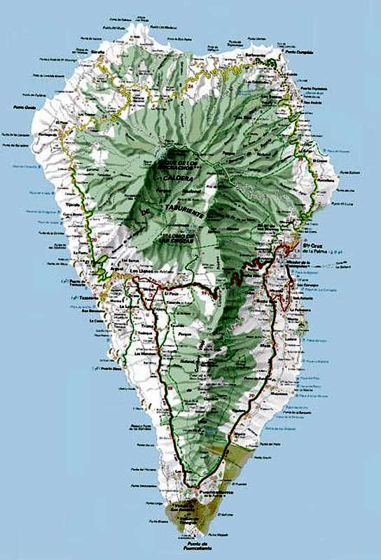 Map of La Palma
First of all let me state that I will post this section to all Cumbre Vieja pages which I intend to post here. Both topics, the geography of the island as well as the Mega-Tsunami Theory are far too interesting to be left out. So if you have read it somewhere before, just skip this section.
Geography
La Palma, like said above and like all the other Canarian Islands is of volcanic origin. Actually you can draw a pretty accurate comparison to the Hawaiian Islands since both groups are similar in many respects. The Canarias have been formed 25 - 2 million years ago with La Palma one of the youngest islends together with tiny El Hierro. What strikes us most today is that the ocean floor around and between the islands is about 4000m deep, which makes mighty Teide (3718m) on Tenerife a truly impressive mountain if you consider the elevation from the ocean floor.
La Palma is not quite as impressive but it is the second highest of the Canarias with its highpoint, Roque de los Muchachos at 2426m. On the other hand it is the third smallest of the islands and thus the ratio of overall material to island area is the largest you will find for any island on earth. This makes it the prime candidate for causing the next mega-tsunami (see below).
The Island can be divided in three mountainous regions:
- the Caldera de Taburiente in the north, the world's largest erosion crater with a diamater of 29km and with caldera walls up to 2000m deep! The caldera is the leftover of a huge volcano which used to exist ages ago and which collapsed by sliding to the west of the island 550.000 years ago.
- the Cumbre Nueva, also the leftover of an even larger volcano. If you look at the little map you will see the Cumbre Nueva in the centre of the island. If you take the curvature of the cumbre and prolong it you will see just how large it really was. This Volcano also dropped away to the west of the island.
- the Cumbre Vieja. Though viejo means old, this is the youngest part of the island by far. Here you can find 120 volcanoes, all very close to each other on this mountain range, which reaches 1945m in height. It is here that the next landslide to the west of the island is expected which is supposed to cause a devastating mega-tsunami.
The Mega Tsunami TheoryClick here for the original scientific paper found by rbi.
To make it short: in 1949, three of the volcanoes of the Cumbre Vieja erupted simultaneously. Large lava flows covered the western parts of the island and there were a lot of heavy earthquakes. During the eruption a large crack developped and the western part of the Cumbre Vieja slipped by 4m (12ft). Since deep chimneys have been found in the higher regions of the range, which all consist of porous, water-filled rocks, it is expected that the next eruption in this central region of the Cumbre Vieja will be so explosive, that the crack of 1949 widens and eventually the western part of the Cumbre Vieja would tumbe into the sea. With huge amounts of material rushing to the sea huge waves would be created, which finally will hit the US and the Gulf of Mexico with devastating effects.
Since La Palma and neighbouring El Hierro have a history of these massive landslides a scenario likes this seems feasible. But nobody knows when - or even if - this will happen. Heavy eruptions occur every 200 years on La Palma and it is far from clear that the crack, which develpped in 1949 actually is deep enough to split the island in two.
Getting There
 Volcan Teneguia as seen from Volcan San Antonio
La Palma, like all the other Canarian Islands can easily be reached from almost all major European airports. The airport is rather small and compared to Tenerife or Gran Canaria air trafic is rather low. There are almost no regular flights but all year round you'll be able to book charter flights.
From the airport it is a 45min trip southward on road LP-1 towards the southernmost town of the island, Los Canarios. Here either take LP-130 to the southern tip of the island for a long 440m ascent or head towards the information center near Volcán San Antonio to the north of Teneguía. If you do the latter be prepared to pay a hefty 3.50€ per person just to walk by the ticket booth.
|


Red Tape
 Volcan Teneguia north summit
As mentioned above the visitor's center at Volcán San Antonio costs a hefty 3.50€, even if you don't want to go inside or park your car in their parking lot. The Mountain itself, in fact every inch south of Los Canarios, is part of the "Monumento Natural de los Volcanes de Teneguía" and has to be treated as such. Part of the eastern half of La Palma's southern tip is used to grow wine so here the limitations are somewhat relaxed but most of the area is off limits to any pollution.
You won't be tempted to collect any plants though, the region is far too barren ;-)
When To Climb
You can climb all of La Palma's mountains almost all of the year. We were very unlucky in that the highest summits around the Caldera de Taburiente were covered in lots of ice covered snow. And who would think of bringing crampons to Paradise?As said above the only limitation for Teneguía is the wind. Though being a low volcano the mountain is by far the highest summit in its area. Therefore the often fierce winds of the Canarias combine to gale-like force. The summit ridge is about 4m (12ft) wide, which is not very much if your flung around by winds.
Camping, Accommodation
Camping is a bit of a problem on La Palma. There are some official campgrounds in the north but the one near Los Canarios is still a project. There are, however, a couple of "Zonas Recreativas" where sometimes you are allowed to pitch a tent. None of these are in the vicinity of Teneguía. The best opportunities are the beaches in the south where camping is not allowed but where you'll probably encounter no objections if you go arrive there late enough and start out early.Other accommodations are no problem. Every European travel office will be able to book hotels, rooms and apartments for you. I won't include any links here because all of them definitely are commercial. Another option is to rent a finca (rural house) from the owners directly. You'll have to google for these but sometimes prices are low enough for the scheme to be worthwhile.
Weather Conditions
I'm a bit at a loss here. Usually all year round the Canarias have the same weather with litlle alterations: north-eastern trade winds which deposit fog and dew on the north-eastern slopes of the islands. The eastern and southern parts usually are very dry and there you'll get some hours of sunshine each day. Especially on the higher islands like La Palma you usually don't have to worry about weather too much. The mountaintops will stick out of the clouds.Now here's my problem: when we were on our vacation to La Palma in late Febuary 2005 we had a week of fierce western winds which were loaded with moisture. We had veritable downpours for ours on end and several times couldn't even drive by car because the roads were flooded. I'm quite sure that this was a freak phenomenon. The wstern side of La Palma usually gets 28cm (19 inches) of rain per year!
There are no reliable weather forecasts for the mountain regions of La Palma. Often a cloudless day turns into a foggy one within half an hour. Especially the Cumbre Vieja Range is prone to these fogs and here orientation among the lava and scree fields gets very difficult. This is the main reason why you should never leave the trails there.
Forecasts for the coastal regions, however are available. You have to substract 1°C for every 100m of altitude so that Roque de los Muchachos will still be near freezing when the coasts have already fine and sunny beach weather. The following table gives a little overview about the average weather data of the capital of Santa Cruz:
| Month | Jan | Feb | Mar | Apr | May | Jun | Jul | Aug | Sep | Oct | Nov | Dec |
| Avg. day temp.[°C / °F] | 21 / 70 | 21 / 70 | 22 / 72 | 22 / 72 | 22 / 72 | 24 / 75 | 25 / 77 | 26 / 79 | 26 / 79 | 26 / 79 | 24 / 75 | 22 / 72 |
| Avg. night temp.[°C / °F] | 15 / 59 | 14 / 57 | 15 / 59 | 16 / 61 | 17 / 63 | 18 / 64 | 19 / 66 | 21 / 70 | 21 / 70 | 19 / 66 | 18 / 64 | 16 / 61 |
| Water temp.[°C / °F] | 19 / 66 | 18 / 64 | 19 / 66 | 19 / 66 | 19 / 66 | 20 / 68 | 22 / 72 | 23 / 73 | 22 / 72 | 22 / 72 | 21 / 70 | 20 / 68 |
| Sunny Hours / Day | 5 | 6 | 6 | 7 | 8 | 9 | 10 | 9 | 8 | 6 | 5 | 5 |
Maps 'n' Books
Please excuse me if I only post German maps and books. I know there are editions in all European languages but I'm not aware of them. Any help is very welcome!I have used a fantastic map by Freytag & Berndt which shows all of the many hiking and biking trails of the island. With its scale of 1:30000 it is still large enough to be usefu for car tours as well. Moreover here you will find all the new designations and acronyms (which were changed some few years back).
- La Palma
1:30000
Edition Freytag & Berndt
ISBN: 3-7079-0346-X
The guidebook I used is every bit as good as the map with excellent tour descriptions. It is available in English as well but I am not sure about the quality of the translation.
- La Palma
A. and W. Wolfsperger
Rother Verlag
ISBN:
3-7633-4246-X (German)
3-7633-4808-5 (English)
MikeLJ - Mar 6, 2023 3:13 am - Voted 10/10
Summit closed to public.There is now a barrier erected to close access to the upper parts of Volcan Teneguia, La Palma in the Canary islands. The reason given is "Conservation reasons". This is a fairly recent development and seems to be a permanent decision. I spoke to a guide on the island for more details, she didn't know why this mountain has been closed and hadn't been able to find anyone else who knew. Many websites still show this path as being open. Please see my photos on this page for details of exactly where on the path this is. This action has nothing to do with the recent (2021) volcanic eruptions on the island, those are further north.