
-
 3592 Hits
-
 73.06% Score
-
 3 Votes
|
|
Route |
|---|---|
|
|
46.91392°N / 11.38493°E |
|
|
Hiking |
|
|
Summer, Fall |
|
|
Half a day |
|
|
Exposed hike |
|
|
Overview
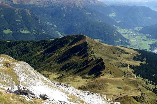 The Rosskopf west ridge seen from Telfer Weissen The Rosskopf west ridge seen from Telfer Weissen |
The climb to Rosskopf along its eastern slopes is an easy and somewhat boring affair. Quite to the contrary to the exposed western ridge. However, I would suggest to ascend via the normal route and descend via the west ridge. Most people do it that way and there are bound to be "traffic jams" if climbed in the opposite direction. Therefore I'll include the normal route and give a descending description of the western ridge route. The ascent to Telfer Weissen / Cime Bianche di Telves concludes the description.
As for its character the western ridge route is easy to find (there's only one ridge) and it is easy to hike and climb. However in places, especially where it gets steep (at both ends of the ridge at Ochsenscharte Saddle and the Rosskopf summit) the path gets very exposed and it is not recommendable to hike it if you have problems with exposure.
Getting There
The desciption can be found on the main page. Just go to the cable-car to the north of Sterzing / Vipiteno and start the climb from its upper station.Route Description
- Start altitude: 1862m
- Summit altitude: 2198m / 2588m
- Prevailing exposure: N and S
- Type: 3h / 5h over marked paths
- Protection: Unprotected except for the final meters to Telfer Weissen
East slopes ascent
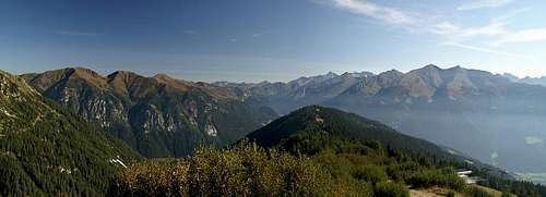 East slopes ascent: View east to Zillertal Alps
From the cable car station turn north in direction of "Jausenstation Rosskopf" and "Sterzinger Haus". At the latter the path turns south-west and heads directly for the summit. The trails are broad and can't be missed. They traverse the ski run meadows to the east of the summit and finally get comparatively steep. The last steps to the summit are a short scramble.
West Ridge Descent to Ochsenscharte
 On the Rosskopf west ridge
(While you actually descend from the Rosskopf summit you climb back up to approximately the same elevation. Therefore the descent could be called ascent as well.)
From the Rosskopf Summit turn directly westward. The path drops by several meters and gets to a small shoulder. From here it drops for about 20m almost vertically, winding through the walls on the crest. Three of these drops follow each other until the path levels and heads along the crest, winding its way up and down the formations on the ridge.
At the western end of the ridge loom the limestone towers of Telfer Weissen / Cime Bianche di Telves, to which ultimately the ridge leads. In between, at roughly the same height as the Roßkopf summit you find a small saddle, Ochsenscharte, which can be used to head back for the cable-car station on either side of the ridge. Shortly before reaching the saddle, the path climbs very steeply to climb a wide tower, the summit of which is passed on the southern side.
On to Telfer Weissen
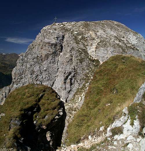 The chimney which separates the eastern from the main summit
The concluding climb to Telfer Weissen at first follows the Rosskopf west ridge / Telfer Weissen east ridge further. However, after Ochsenscharte it loses its knife-edge quality, since on the northern side the slopes get shallower. The path has deep ruts which make scrambling up a bit tedious. After a small lake the trail turns right (north to head directly to the Telfer Weissen north-east ridge, which connects the summit with neighbouring Schleyerwand / Monte Velo. You have to cross fields of white limestone scree which hurts the eyes on bright summer days. Before you reach the saddle between the mountains the path turns left (west) sharply and scrambles up to a col east of the Telfer Weissen east summit.
From the col you have a beautiful view towards the Tribulaun Group across the Pflerschtal Valley / Val di Fleres. Prepare yourself for the final stage here, because a few more steps will take you to a chimney which heads down into the saddle between eastern and main summits. The chimney is very steep and very narrow but equipped with a strong firmly anchored cable. Thus the descent is rather more easy than it looks. You might want to leave backpack and/or walking poles at its entry, however.
Heading out of the chimney you reach the saddle, which already is quite exposed. A cable marks the further path. This cable, however is not anchored in its bottom part so that reaching the summit is a bit of a hassle. Take care nor to produce rockfall as the saddle is in the straight downwards line from the scree covered path. The summit cross is located to the south, the highest point a bit further to the north.