
-
 8074 Hits
-
 81.18% Score
-
 13 Votes
|
|
Mountain/Rock |
|---|---|
|
|
46.92143°N / 11.35016°E |
|
|
Scrambling |
|
|
Spring, Summer, Fall |
|
|
8491 ft / 2588 m |
|
|
Overview
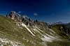
 Telfer Weissen / Cime Bianche di Telves as seen from the south-west Telfer Weissen / Cime Bianche di Telves as seen from the south-west |
In the southern Stubai Alps you can find quite a number of mountains, the summits of which are composed by white limestone, sometimes dolomite or even marble, which contrasts perfectly with the otherwise reddish micaceous schist which forms their base. Moreover, often the actual mountaintops decompose into several separate, tower-like summits, which generally is reflected in the names of these mountains. They often carriy a "weiss" (German) or "biancho" (Italian) in them, thus indicating their colour. Ratschingser Weissen, Moarer Weissen, Telfer Weissen are all composed of separate summit structures and it is the latter that this page is concerned about.
Telfer Weissen / Cime Bianche di Telves are some four summits on the Aggls-Rosskopf ridge in the southern Stubai Alps, a ridge which runs from the central main ridge westward and ends on Rosskopf / Monte Cavallo directly above the town of Sterzin in Eisacktal Valley / Valle Isarco. At Telfer Weissen a secondary ridge turns of to the north-east, ending with the limestone structures of Schleyerwand. Several trails lead up to the summit ridge of Telfer Weissen, where they combine in the Ochsenscharte Saddle, to the east of the summit.
Without the help of the cable-car which heads up the Ross kopf east slopes, climbing Telfer Wessen would be a major undertaking. The towns and villages of the area are located in the valleys between 1500m and 2000m underneath and the shortest ascent would have to climb 1300m (from the village of Tellfes to the south of the mountain). With the chairlift, however, the climbing time is reduced greatly, though you still have to account for three to four hours of climbing time.
Depending on the route you take climbing will be easy until you reach the summit towers. There - between the eastern and the main summit - a profound chimney has to be descended with a scree covered ascent thereafter. The chimney is equipped with strong cables and thus poses only minor problems but the main summit ascent is rather tricky. While it also is equipped with cables, the cables are fixed only in a few positions with the lower part hanging around loosely. The gravel on the rocks during the ascent makes this part very slippery and a lot of care has to be taken to avoid rockkfall onto climbers waiting in the saddle beyond the chimney exit underneath.
And there will be climbers. Telfer Weissen are rather popular (thanks to the cable-car of course) and while the final ascent keeps away the worst crowds you will always find the summit occupied. Thanks to its position on the east of the Aggls - Rosskopf ridge the main summit offers great views towards the Stubai Alps main ridge and the mountain groups around. It is located right across the Pflersch Valley / Val di Fleres from Pflerscher Tribulaun, the most remarkable mountain structure of the whole area.
One last note on climbing Telfer Weissen / Cime Bianche di Telves: The most interesting route is the ridge, which connects it with Rosskopf / Monte Cavallo, which can be easily climbed from the cable-car. The ridge is knife-edged but not very profound - the climb along its crest is a constant up and down, avoiding, sometimes climbing, the many rocky structures along the way. It takes much longer than any of the regular routes but it definitely is worth the time.
|


360° Summit Panorama
  |
Getting There
 The Tribulaun Group as seen from Telfer Weissen
Suggesting that you make use of the cable-car, getting to the mountain is very easy. From the Brenner Motorway A22 take the Sterzing / Vipiteno exit. Go east to SS12 "Brenner Staatsstrasse and drive northward, direction Brenner. Shortly after you leave the town of Sterzing / Vipiteno you'll see the cable car on the left hand side.
|


Red Tape
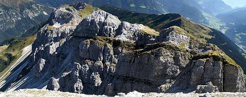 The eastern summit of Telfer Weissen as seen from the main one
There's no red tape here except for the obvious rule to close cattle gates. The parking lot near the cable-car is free but almost anywhere else in Sterzing you have to pay for the parking lots.
Accommodation
Rooms and Apartments
The closest accommodation to be found are in Sterzing, Gossensass, Pfitsch and Ridnaun. You can find accommodation info for all four locations on the following link:
Camping
There is a campground at Gasteig / Casateia in Ratschingstal / Valle di Racines to the south of the mountain. The campground is called "Gilfenklamm" and is located on SS44 to Jaufenpass / Passo del Giovo.
Huts etc
There is no need to worry about food as there are half a dozen of huts, alm houses and restaurants on the eastern slopes of Rosskopf / Monte Cavallo. The closest one are Ochsenalm and Vallmingalm to the south and north-east resp. of the Ochsenscharte Saddle.
Weather Information
Maps & Books
Maps
- Digital Maps
- Regular Maps
- Sarntal/Val Sarentino
Kompass Map WK 056
1:35.000
ISBN: 3-85491-340-0
- Sterzing / Vipiteno
Kompass Map WK 44
1:50.000
ISBN: 3-85491-050-9
Books
- Rund um Sterzing
Henriette Klier / Walter Klier
Rother Verlag
ISBN: 3-7633-4167-6
- Sarntal/Val Sarentino