
-
 10169 Hits
-
 89.01% Score
-
 28 Votes
|
|
Mountain/Rock |
|---|---|
|
|
46.91392°N / 11.38493°E |
|
|
Hiking |
|
|
Spring, Summer, Fall, Winter |
|
|
7211 ft / 2198 m |
|
|
Overview
 Roßkopf / Monte Cavallo seen from the western ridge Roßkopf / Monte Cavallo seen from the western ridge |
Granted: this is the lowest mountain of its whole Alpine subgroup. Also granted: there is a cable-car which almost reaches its top. And yes, there are about four ski lifts on its eastern slopes, which certainly are a sight not to see. The path from the cable-car to the summit is wide and well-trodden, the summit itself popular and crowded (especially since there is not much space up there. So why climb Roßkopf / Monte Cavallo.
The main reason is: looks. Not of the mountain itself though there are aspects from which it actually is quite beautiful. No, the looks all around are the sight to see and certainly worthy to brave the crowds. Roßkopf belongs to the Stubai Alps and is located at the eastern end of the ridge, which runs south-east from the main ridge starting at the Feuerstein summits with Agglsspitze / Cima dell'Accla and ends - well - at Roßkopf. In German literature that subgroup of the Stubai Alps therefore is called Agls - Roßkopf Kamm. As the endpoint of the ridge Roßkopf towers over the Eisacktal Valley / Val Isarco above the town of Sterzing / Vipiteno. The valley is more than 1000m lower than the summit which explains why the cable-car is so popular, even among serious mountaineers. You lose several hours and a lot of strength if you start out from the valley below.
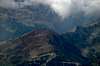
Across the Eisacktal Valley loom the first mountains of the Zillertal Alps, another ridge, which ends almost at the same spot. This is the Tux Main Ridge running from north-east to south-west with equally impressive mountains almost at your fingetip. Eisacktal itself turns south-east at Sterzing giving you a faraway view of the western Dolomites in the mist 60km away while to the south, across the ridges of the Botzer Group of the Stubai Alps the lonesome summits of the northern Sarntal Alps are to be seen.
Yet, there is another attraction to climbing Roßkopf / Monte Cavallo, its knife-edge western ridge. For more than a kilometre this ridge winds up and down, left and right, sometimes very steeply, sometimes flat but exposed at all times. I would not judge it as difficult but definitely you must be used to exposure. Most people climb Roßkopf via its normal route from the east, some try to descend via the western ridge. Most, however, turn around after the first steps as the path winds down almost vertically towards the crest. The climb of Roßkopf can be combined with its neighbour, Telfer Weißen / Cime Bianche di Telves, a very long climb, especially when done along the Roßkopf western ridge.
|


360° Summit Panorama
Cima PresanellaHasenöhrlKolbenspitzeMareiter SteinLodnerHohe WeißeKleine KreuzspitzeHohe WildeHohe KreuzspitzeHochspitzeSeelenkögelLiebener SpitzeHochfirstHohe FerseGleckspitzeRatschingser WeißenMoarer WeißenBotzerTelfer WeißenPflerscher TribulaunGschnitzer TribulaunSchwarze WandNördl. RoßlaufObernberger TribulaunSchleyerwandSchleyerbergGrubenkopfGeierskragenHoher LorenzenSattelbergT u x A l p sLizumer RecknerHohe WarteKleiner KasererGroßer KasererOlpererSagewandSchrammacherHohe WandDaxspitzeRollspitze / HühnerspielWeißspitzeGrabspitzeWilde KreuzspitzeBlickenspitzeSaunPfunderer BergeDrei ZinnenPrags DolomitesFanes GroupGeisler GroupKönigsangersp.TatschspitzeTagewaldhornZinselerJakobspitzeHühnerspielHohe ScheibenRöthenspitzeSarner WeißhornÖtschspitzeHochplattspitzeHochwartJaufenspitze   |
Getting There
 Roßkopf / Monte Cavallo in front of the Tux Main Ridge
Suggesting that you make use of the cable-car, getting to the mountain is very easy. From the Brenner Motorway A22 take the Sterzing / Vipiteno exit. Go east to SS12 "Brenner Staatsstraße and drive northward, direction Brenner. Shortly after you leave the town of Sterzing / Vipiteno you'll see the cable car on the left hand side.
Red Tape
 Summit view towards the Ötztal Alps in the west
There's no red tape here except for the obvious rule to close cattle gates. The parking lot near the cable-car is free but almost anywhere else in Sterzing you have to pay for the parking lots.
Accommodation
Rooms and Apartments
The closest accomodation to be found are in Sterzing, Gossensass, Pfitsch and Ridnaun. You can find accommodation info for all four locations on the following link:
Camping
There is a campground at Gasteig / Casateia in Ratschingstal / Valle di Racines to the south of the mountain. The campground is called "Gilfenklamm" and is located on SS44 to Jaufenpass / Passo del Giovo.
Huts etc
There is no need to worry about food as there are half a dozen of huts, alm houses and restaurants in the direct vicinity of the mountain. The closest is Sternhütte to the east of the summit.