
|
|
Route |
|---|---|
|
|
53.06804°N / 4.07764°W |
|
|
Hiking |
|
|
Spring, Summer, Fall, Winter |
|
|
Most of a day |
|
|
walk up3½ miles, 2¾ hrs |
|
|
Overview
The Snowdon Ranger Path provides an easy route to the summit of Snowdon, and is easily achievable by walkers of all abilities. It is probably one of the oldest routes up the mountain, and is most likely named after, John Morton one of Snowdonia's first guides, who opened the Snowdon Ranger Inn, the building at the start of the route which is now a YHA hostel. When combined with the Rhyd Ddu Path, either as an ascent of descent route, it becomes part of a classic Welsh horseshoe set amongst some of the best scenery on the country.
Getting There
The Snowdon Ranger Path starts at the Snowdon Ranger Station car park (SH 565 551) on the Welsh Highland Railway and is located on the A4085 between Beddgelert (SH 590 481) and Caernarfon (SH 482 625). This is an ideal starting point for those wanting to climb on Clogwyn Du'r Arddu (SH 602 554). The carpark is also serviced by the Snowdon Sherpa
bus service which has various stops around the mountain and runs from Llanberis, Bettws y Coed, Caernarfon, Beddgelert, Bethesda and Porthmadog. Be sure to check timetables first as you don't want to end up missing the last bus and find yourself stuck, of course in these situations hitching is always an option.
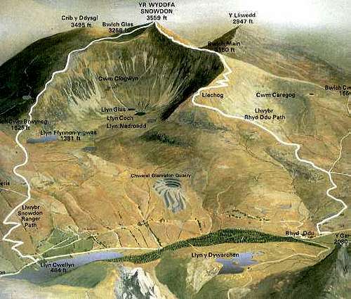 Diagram of the Snowdon Ranger Path (left)
Route Description
The route starts on the A4085 next the Snowdon Ranger Y.H. and heads to the left along the side of the Snowdon Highland Railway first built in 1878 to connect Caernarfon and Beddgelert, it has now been re-opened and expanded all the way to Porthadog. A signpost directs the route right behind the Llwyn Onn farmhouse and Zig-Zags up the open hillside.
After some 500 metres the path levels out, and crosses two streams. From here it continues over the southern slopes of Moel Cynghorion, avoiding the marshy ground in Cwm Clogwyn, where five small lakes cluster. From here the path heads up to Bwlch Cwm Brwynog which is reached at around 490m. The going gets harder as the route climbs upwards gradually steepening along a cairn-marked path to the top of Clogwyn Du'r Arddu.
A monolith marks the point where the Snowdon Ranger Path meets the Snowdon Railway and the Llanberis Path, these tall standing-stones can be invaluable reference points to help you from loosing your way in poor visibility. The route then joins the Llanberis Path on its way to Snowdon's summit.
Essential Gear
Just a good pair of boots, waterproofs and some lunch. If walking in winter conditions make sure you also carry an ice axe and crampons.
Maps
Navigation Maps
OS 1:25k Explorer Series OL 17 Snowdon/Yr Wyddfa
OS 1:50k Landranger Series 115 Snowdon/Yr Wyddfa
Harvey Map Services 1:25k: Snowdonia North: Snowdon, Glyders, Carnedds
Harvey Map Services 1:25k: Snowdon
Harvey Map Services/BMC 1: 40k British Mountain Map: Snowdonia North
Road Maps
OS Travel Map 10 Wales/Cymru & West Midlands
Guidebooks
 |
 |
Snowdonia (Official National Park Guide) by Merfyn Williams
The Mountains of England and Wales: Volume 1 Wales (Cicerone Guide) by John and Anne Nuttall
Hillwalking in Wales Vol 1 (Cicerone Guide) by Peter Hermon
Hillwalking in Wales Vol 2 (Cicerone Guide) by Peter Hermon
Hillwalking in Snowdonia (Cicerone Guide) by Steve Ashton
External Links
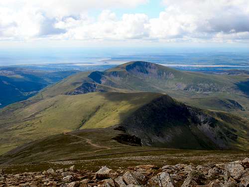
The Snowdon Ranger Path (Foreground) and Snowdon's northern peaks (background)
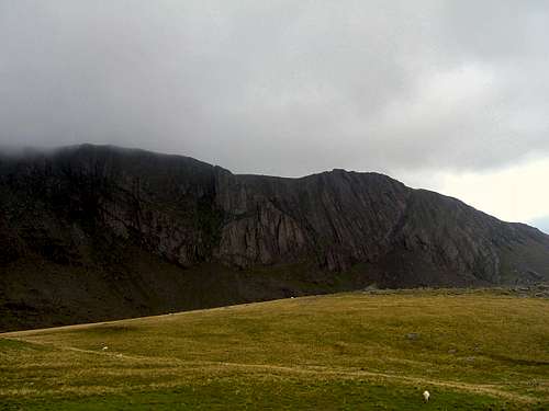
Clogwyn Du'r Arddu
Government Bodies and Official Organisations
Snowdonia National Park Authority
Association of National Park Authorities
Royal Commission on Ancient & Historical Monuments in Wales
Hiking, Climbing and Mountaineering Organisations and Companies
British Mountaineering Council
Plas y Brenin National Mountain Centre
Weather
Tourist Information
North Wales Tourism Partnership
Local Information from Gwynedd.com
Local Information from Snowdonia Wales Net
Travel
Welsh Public Transport Information
Accommodation
Youth Hostel Association in Wales
Maps and Guidebooks
Cordee Travel and Adventure Sports Bookshop
Wildlife and Conservation
Joint Nature Conservation Committee
Royal Society for the Protection of Birds