
-
 50802 Hits
-
 91.7% Score
-
 36 Votes
|
|
Route |
|---|---|
|
|
47.41670°N / 10.98330°E |
|
|
hike, easy scrambling, glacier, via ferrata |
|
|
One to two days |
|
|
medium via ferrata |
|
|
Overview
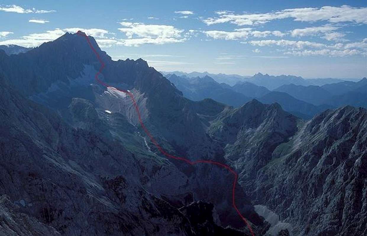
This is the nicest ascent of the highest mountain of Germany. It leads through a suberb landscape on a diversified route that crosses all scales of elevation: Low meadows, forest, a spectacular canyon, a scenic high valley, slabs, moraines, a glacier, and a rockface to the summit that is well-secured with cables.
As you probably know the summit itself is not so romantic, but it has the advantage that you can choose from three cablecars how to get down again easily…
Referring to the guidelines of this fact sheet
General data:
- Start altitude: 775 m
- Summit altitude: 2962 m
- Prevailing exposition: NE, N
- Type: hike, sometimes on rough terrain, easy scrambling, glacier, via ferrata
- Protection: well marked (except on the glacier) good protection with pegs and cables
Effort (ascent), 2190 m ascent, very strenuous as a daytrip; 6-8 h
Power: 2-3
Psyche: 3
Orientation: 1-2, very often done
Approach
Starting point is the train station of the Zugspitz Railway at the village Hammersbach (775 m), belonging to Grainau near Garmisch Partenkirchen.
If you arrive with private car: There is a chargeable car park but you are not allowed to stay overnight. If you want to do this, my advice is to leave your car at the free parking of Kreuzeck cablecar. From there it is half an hour even walk over the meadows to Hammersbach.
 |
Route Description
From Hammersbach follow the broad trail first left than right of the Hammersbach creek upstream, later with some zig-zags to the entrance of the Hoellentalklamm canyon where you have to pay an entrance fee (about 3 EUR I believe).


The canyon is spectacular but very wet so even on fine days it is advisable to use rain clothes!
Behind the canyon further on on a hiking trail to Hoellentalanger hut (1379 m), 2 h from Hammersbach. If you had arrived just that day you will probably stay here for the night.
After the hut you cross the valley and follow the trail (after the route to Riffelscharte pass had branched off) to the first cables that lead to the row of iron pegs called "Leiter".

Behind that the exposed traverse of a steep slab called "Brett" is probably the most photographed section of the whole route…

The route then passes the highest meadows and leads through to the scree of the moraines strenuously up to the Hoellental glacier.


There is always a trail in the snow and there are only few crevasses. Most parties do not rope here. But there can be pure ice already in July , then crampons are necessary. The route climbs the glacier first directly then does a curve to the right to reach the final crevasse that separates glacier and rock.

The traverse of this gap may be tricky.
Now the route is a easy to medium via ferrata. Clicking your harness into the cables calms your nerves. After climbing the first part directly the route climbs to SW to Irmerscharte pass where you can look down to the beautiful Eibsee lake.


Then you stay left and climb through the northern flank, where often snow and ice had remained, to the ridge and near the ridge to the right to the summit cross.


Best Time
July to mid October.
Be aware that Hoellentalklamm canyon is closed from late fall until May. But at the closure time doing the route is much more difficult.
If there is not too much fresh snow, beginning of November is still a possible time - picture gallery of an ascent on November 2nd 2005.
Accomodation

Hoellentalanger hut (1379 m): 65 beds, guided from July to mid October, Tel. 08821/8811
Münchner Haus on top of Zugspitze (ca. 2955 m): 30 (small) beds, no washing water (but there are toilets with water in the nearby cablecar stations…). Tel. 08821/2901. Guided from mid May to October.
Sleeping on top of Zugspitze is a great experience if weather fits. In spite of the many buildings it is a peaceful and calm site up there as soon as the last cablecar has left. But space is limited so there are some guidelines to follow: reservations are possible for members of the alpine clubs but not for a Saturday evening. If you have a reservation you must check in at 3 p.m. Non-members get their place not before 7.30 p.m. If the hut is crowded one bed has to do it for two people!
Reservations in advance are advisable for both huts.
My personal experience on a fine weekend in August: Reservations per phone were not possible any more two weeks before. But we (two people) arrived early at these huts and we are members of the german alpine club. If you are in a bigger group or if you are not member of an associated alpine club, you surely have problems of getting a place for sleeping. According to a information of the German Alpine Club (Deutscher Alpenverein) associated alpine clubs are:
- Österreichischer Alpenverein
- Club Alpin Francais
- Federacion Espanola de Montanismo
- Club Alpino Italiano
- Schweizer Alpen Club
- Club Alpin Berge
- Dansk Bjergklub
- Alpenverein Südtirol
- Lichtensteiner Alpenverein
- Groupe Alpin Luxembourgeois
- Nederlands Klim-en Bergsport Vereniging
- Planinska Zveza Slovenia.
Essential Gear
Hiking gear, harness, two slings and biners for the via ferrata (necessary if you are not experienced in such terrain), helmet. Crampons if the glacier has pure ice (you may ask per phone in advance at Hoellentalanger hut)
Map
Best map is the map of the German alpine club, "Alpenvereinskarte" Nr. 4/2 "Wetterstein und Mieminger Gebirge", Mittleres Blatt (mid sheet), ISBN 3-928777-20-3
Miscellaneous Info
If you have information about this route that doesn't pertain to any of the other sections, please add it here.
 |
 |
mcc - Feb 14, 2005 3:39 pm - Hasn't voted
Route Commentif youre going to try it early after Hollentalklamm is opened , you definitely should take a rope , and ice axes can prove useful , in May whole ferrata above the glacier may be under the ice and snow , so you need to make the way yourself