
-
 13648 Hits
-
 80.49% Score
-
 12 Votes
|
|
Route |
|---|---|
|
|
36.03265°N / 111.85245°W |
|
|
Hiking |
|
|
Spring, Fall, Winter |
|
|
A long day |
|
|
Snow hiking in winter |
|
|
Overview
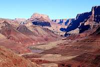
Th trail follows an ancient Indian route which was later improved by the 19th century prospectors. It is quite remarkable for its unusually wide landscape. The lower section of the canyon here consists of the soft rocks of the Grand Canyon Supergroup which have eroded into a broad, open valley at the river's edge. This is quite the opposite to the view of the Inner Gorge lower down the river.The trail provides the access to the Escalante trail to the west and the Beamer Trail up the river. Following Escalante route will provides excellent opportunities to link the trail legs with other popular routes (New Hance, Grand View, South Kaibab, Bright Angel etc.)
Getting There
Park at Lipan Point, walk back down the road a few steps, and look for the trailhead east of the pavement. The Lipan Point is in the eastern section of the park a few miles away from the prominent tower at the Desert View viewpoint.Follow Desert View Drive tp the Lipan Point turn-off, 2.3 miles west of Desert View Entrance Station and 20 miles east of the Village Loop junction with AZ-64 Highway.
Route Description
Locations/Elevations/MilageLipan Point (7350 ft / 2240 m) to Colorado River (2700 ft / 823 m):
9 mi (14.4 km)
Water Sources
The Colorado River is the sole source of water. No reliable water exists above the shoreline. The Colorado is often silt laden and can be difficult to purify under those conditions.
Description
From the parking lot of Lipan Point walk back down the access road to the stand marking the beginning of the trail. The upper section of the Tanner Trail is narrow, badly eroded, and can be difficult to follow, especially after a winter storm.
The trail stays on the slopes east of the bottom of the gully and switches to the west side. Be careful to choose the first (western most gully) for initial descent from the rim. There are at least 3 steep gullies in the area and none of them look inviting. If the trail is not visible or covered with snow look for remnants of the trail on the weatern side of the canyon. Be careful not to drop too low as traversing on the sandy ledges or snow can be hard and dangerous.
The trail descends steeply across the slope west of the bed of gully nearly all the way to the Seventyfive Mile Creek - Tanner Canyon saddle. The initial descent drops about 1800 ft.

A prime canyon view at the saddle is the one the most majestic views one can obtain in GCNP.
The next three miles are mostly traversing with little elevation loss and gain along the Supai. The trail contours around the base of Escalante and Cardenas Buttes, goes up to cross a small ridge and descends to the top of the Redwall. Walk the rim of the limestone north; watching for the place the trail starts down the Redwall cliff.
Before going down the Redwall descent, walk the short path to the view point 100 yards away with incredible views of Colorado River and lower reaches of the canyon.
The Redwall descent is steep and it drops ~2000 ft with short switchbacks and then traverses along the loose slopes and finally descends to the river. There are several spots where youi can put the camp, but the preferred way is to get down to the river as it provides water and better shelter from the wind rolling down from the rim.
From Here
The Tanner Trail is used as an entrance to the Beamer Trail

to upper reaches of Colorado River (10 ml one way to the Little Colorado) or the Escalante Route

that leads west to other areas of the Inner Canyon and can be linked to New Hance, Grand View, South Kaibab and other trails to the west of the Lipan Point.
Camping
Tanner Canyon Use Area (BB9) allows "at-large" camping.
There are nice (although dry) established campsites at the Seventyfive Mile Creek - Tanner Canyon saddle, trailside in the Supai, above and below the Redwall, and in the Tapeats. Campsites near the river can be found on the east side of Tanner Canyon. A composting toilet is located nearby.
There is large sandy beach to west of the toilet with good camping spots surrounded by the vegetation.
Essential Gear
Hiking gear and plenty of water (before you reach the Colorado River, there aren't any reliable sources of water)In winter boots suitable for hiking in the snow and ice traction devices are needed. After the snowfall the upper reaches of the Tanner Canyon are covered with snow and the trail may be difficult to follow. Use map and look out for the clues of he trail in the lower sections. Strong winds re common and the proper sturdy tent is required.
External Links
NPS Tanner Trail DescriptionTrip reports:
http://www.grandcanyonhiker.com/trip_reports/karsh/
http://www.toddshikingguide.com/Hikes/Arizona/GrandCanyon/Canyon12.htm
http://www.americansouthwest.net/arizona/grand_canyon/tanner_trail.html
Water
The Colorado River is the sole source of water. No reliable water exists above the shoreline. The Colorado is often silt laden and can be difficult to purify under those conditions.Use collapsable bucket to let the silt to settle before using the filter.
In winter it is possible to melt the water from the snow/ice, so plan the stove/fuel properly.
Water caches can be placed in many places along the route.
Milage
0.0 Start at Lipan Point parking area1.9 75-Mile Saddle, great views
3.5 Top of the Redwall below Gardenas Butte. Viewpoint
7.5 Junction with the Beamer Trail
7.6 Tanner Beach, Coloradi River
Rinat Shagisultanov - Jan 6, 2009 2:18 am - Hasn't voted
Re: Cut and pasteThanks for pointing to the copyright. It has been cleared from the direct cut and paste content. I wish SP had a draft version of the page that you can use as interim state w/o making it public immediately after submitting it. BTW, NPS does not specifically protects the content of the site or the trail description used in the v.1 of the page. See http://www.nps.gov/disclaimer.htm
Bob Sihler - Jan 6, 2009 7:52 am - Voted 10/10
Re: Cut and pasteThanks. The standard on PnP is not to cut and paste much at all-- uncomplicated driving directions and regulations are examples of things that are okay, but other material should be based on personal experience and description. What I usually do is write my text off-site and then make the page here when it is ready. Anyway, I changed my vote. You might want to send PMs to the others who downvoted; they did so because of the copy-paste matter. Cheers.
Bob Sihler - Jan 6, 2009 10:58 pm - Voted 10/10
Re: Cut and pasteRinat, I went ahead and contacted the others I mentioned, and they changed their votes. Thank you for changing the page and being receptive to constructive criticism. I hope to see more nice submissions (and more nice pictures) from you! P.S. I'll also be deleting my other comments since they no longer are relevant.