
-
 27708 Hits
-
 77.48% Score
-
 8 Votes
|
|
Route |
|---|---|
|
|
Hiking, Scrambling |
|
|
Spring, Summer, Fall, Winter |
|
|
Half a day |
|
|
Class 3 on Crumbly Rock |
|
|


Overview
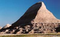
A trip through this landscape takes you alternately through some of the last remaining examples of the shortgrass prairie that once covered the western U.S. Great Plains and the soaring, rugged, eroded pinnacles that led Native Americans and European explorers and trappers alike to describe them in terms that ultimately translated into English as the badlands. It is a trip into not only inspiring scenery but also an America that largely no longer exists except in songs, tales, and movies.
There is only a handful of maintained hiking trails in Badlands National Park, the best-known of which are the Door, Notch, and Window Trails north of Cedar Pass near park headquarters. Those three are short, easy, and spectacular, and they pass for popular in this park that rarely seems crowded. However, the Saddle Pass Trail, even though it, too, is close to park headquarters, a campground, and a lodge, is not nearly as busy, and once the road below is out of sight, you will feel as though you are deep in the wilderness, or maybe even in another world.
The trail system is rewarding in its own right, but people afflicted with the mountaineering bug will be drawn to hike/scramble up any of the seemingly countless unnamed formations to enjoy a sweeping view of the area. Just stay off the formations when they're wet; they'll be too slick for safe climbing, anyway, and you'll harm the fragile landscape as well.
I probably sound like a broken record when it comes to talking about solitude, but here goes, anyway: although Badlands National Park, with its vast open spaces and paucity of established trails, is tailor-made for solitude-seekers, the Saddle Pass system offers a great serving of solitude for those who prefer to stay on or close to maintained trails.
Getting There
The trailhead is at a parking area on the north side of SD 240 about 2 miles west of the developed area where the park headquarters, campground, and Cedar Pass Lodge are found.
Route Information
The trail up to Saddle Pass itself is only about 0.25 mi (though very steep) in length. The Castle Trail, though, runs for 5 miles between its western end at the Fossil Exhibit Trail and its eastern end at the major trailhead a short distance north of Cedar Pass. The Castle Trail is mostly level for much of the way; at times, it passes beneath the types of otherwordly formations that give the area its name, and at other times it passes through the prairie (watch for cactus in that grass), although the badlands are always near. At the junction of the Saddle Pass Trail and the Castle Trail is also the western terminus of the Medicine Root Trail (its eastern end is on the Castle Trail), which winds for 4 miles through a gently rolling prairie setting while offering views of the badlands in the (not too far) distance.
This route is accessible all year, but it can be bitterly cold and windy here in winter. In summer, hike early or late in the day to avoid the intense heat and sun that bake this landscape for most of the day.
Click here and then on "View Map" to see a map version of the trail system.
Essential Gear
Good hiking boots will do it. Don't forget sunscreen and plenty of water in summer, when temperatures frequently rise above 100 degrees Fahrenheit.