
-
 18385 Hits
-
 86.37% Score
-
 22 Votes
|
|
Route |
|---|---|
|
|
29.16498°N / 103.61532°W |
|
|
Hiking |
|
|
Spring, Summer, Fall, Winter |
|
|
Less than two hours |
|
|
Easy |
|
|
Overview
Big Bend National Park, TX has three remarkable slot canyons: Boquillas, Mariscal and Santa Elena. Of these, the trail into Santa Elena is considered by many to be the most scenic in the park. This canyon is a 1500-foot gash that runs for eight miles in the uplift that forms the Sierra Ponce Mountains in the southwestern corner of the park. At some points, the limestone walls are separated by as little as 150 feet. You can see this impressive canyon well on Google® Earth. It has been cut by the Rio Grande River, which divides the U.S. from Mexico. The area above the canyon on the U.S. side is known as Mesa de Anguilla.Getting There

Area map courtesy of NPS.
There are two ways to the Santa Elena Canyon Trail trailhead: Drive either 30 miles southwest of the Santa Elena Junction via the Ross Maxwell Scenic Drive, or thirteen miles southwest of the Maverick Junction via Old Maverick Road (a high clearance vehicle might prove useful on this washboard gravel road, but it’s not required). Indeed, there is lots of scenery along both drives, so consider making a loop of the trip. There is plenty of parking at the trailhead, as well as restrooms. In the event of flooding along the Rio Grande, expect both roads to be closed for several days after the surge has passed.
Route Description

Quad topo extract.
Access to the canyon is provided on a short trail (about 0.8-miles in length). This trail may be closed during peregrine falcon nesting season (early spring) - check with the National Park Service. The trail doesn’t have much vertical elevation change. In fact, you end basically at the elevation at which you start, though you will need to climb about 80 vertical feet up some steps near the entrance to the canyon.
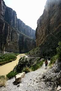
Hiking into the canyon.
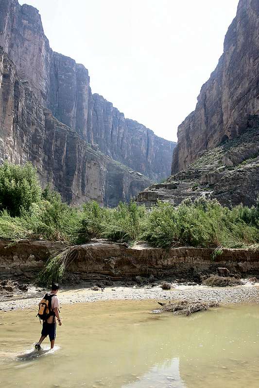
At first, there isn’t really much of a trail. The entry to Santa Elena Canyon will be patently obvious, but the sands of Terlingua Creek, which has its confluence with the Rio Grande near the mouth of the canyon, will obscure any evidence of an obvious trail. You will need to wade across Terlingua Creek to find the real trailhead. Look part way up the canyon walls and you should see a railing that marks where the steps are cut into the rock (you can see the railing in this image). Head towards that railing, while keeping an eye on the far bank of Terlingua Creek. You’re searching for a rock cairn that marks the exit point from the creek. You will have to climb the small, and possibly muddy, face of a small drop-off to get onto the shore. After that, strike a path through the scrub brush, heading generally for the railing where it drops down to the Rio Grande River. You should arrive at some steps that take you up to that railing, and then back down the other side, where you'll be surrounded by the steep walls of Santa Elena Canyon. From there the trail is a typically nice National Park Service hiking path along the U.S. bank of the Rio Grande, before continuing through the lush, riparian vegetation near river level.
Eventually the trail will end where the canyon walls meet the river – for further exploration, consider taking a canoe, kayak or raft. One can paddle a few miles upstream into the canyon, and then return to the starting point. Put-in can be either at the Santa Elena Canyon trailhead, or 1-1/4 miles downstream on river left. At low water level, there isn't much current to fight while going upstream (you can check the current water level here). With an average gradient of 7 feet/mile, this trip can be quite leisurely. A good destination is Fern Canyon, a beautiful side canyon where ferns grow out of the canyon walls. It is located approximately two miles upstream from the trailhead. A backcountry-use permit is required for all river trips; but no fee is charged for day-use trips. You may find information on backcountry-use permits here. At high water levels, be aware that there can be Class IV rapids within Santa Elena Canyon. Also, if boating solo, be prepared to offer additional information and to submit to having yourself, your gear and your bootprint photographed. You will need to check back in within 12 hours of leaving the backcountry. You can find additional information on solo backcountry use here.

Nice view of the Chisos Mountains from Santa Elena Canyon. Imaged by Bubba Suess.
Essential Gear
Take sufficient water. Even if you have a means to purify water, the Rio Grande is very muddy and would either not be very appetizing (if using chemical treatment), or would clog your filter very quickly. This is a pretty easy hike, so you might wish to doff the hiking boots for a pair of sandals (closed-toe recommended) or water shoes for the creek crossing.Other Precautions

Thorny mesquite.
It seems like every plant in Big Bend has needles. Be cautious where you put your hands!
In the summer, it can be quite hot (100 degrees plus). You may wish to hike in the early morning, or in the latter part of the day. Fortunately, the steep canyon walls provide some shade during most of the day.
A sudden rain could cause flash flooding along this route. Since your way out is the way you came in, you want to ensure that the weather will cooperate. Indeed, if there have been heavy rains upriver (either the Rio Grande or Terlingua Creek) in the past few days, expect lots of mud along the trail. Much of the water flow in the Rio Grande through Santa Elena Canyon comes from Mexico's Rio Concho (near Presidio, TX), so keep an eye on weather effects in that area, too.

Rising waters in Terlingua Creek. Imaged by Sbrande.
Bob Sihler recommends what is prudent advice for any trailhead: Before departing your vehicle, be certain to secure valuables and lock it.
Finally, as previously mentioned, this is the U.S./Mexico border. It’s easy to step into the muddy Rio Grande (Rio Bravo del Norte to the Mexicans) and cross into Mexico. It’s also illegal. It’s very unlikely that anyone would see you doing this, but do be aware that if you’re caught, you could be in for a serious encounter with the authorities.
External Links
o Big Bend National Park Official Website - Backcountry Use PermitsInformation on obtaining a backcountry use permit. A permit is required for overnight use, and for any river trips.
o Big Bend National Park Official Website - Solo Hikers and Boaters
Information about registration requirements for solo hikers and boaters in Big Bend National Park.
o Rio Grande Wild & Scenic River Official Website - River-Use Regulations
Regulations regarding use of the Rio Grande River, including within Santa Elena Canyon.
o Texas A&M Website - Santa Elena Canyon Flora
Information about flora in Santa Elena Canyon. Includes photos for identification, and describes plant uses.
o Castolon Quadrangle Topo Map (.tiff)
Quick link to the USGS Castolon quadrangle that includes Santa Elena Canyon Trail. This large file is used under the Creative Commons License.
o Mesa de Anguila Quadrangle Topo Map (.tiff)
Quick link to the USGS Mesa de Anguila quadrangle that includes the western parts of Santa Elena Canyon (beyond the hiking trail). This large file is used under the Creative Commons License.
o USGS Water Data for Rio Grande River near Castolon
Real time water data for the Rio Grande River at Castolon in Big Bend National Park (seven miles downriver from Santa Elena Canyon exit).
o NWS Weather Forecast for Terlingua, TX
Weather forecast for nearby Terlingua, TX (11 miles away from Santa Elena Canyon). Includes current conditions at the Casparis Municipal Airport in Alpine, TX (85 miles away).