
-
 10903 Hits
-
 88.19% Score
-
 26 Votes
|
|
Mountain/Rock |
|---|---|
|
|
48.48482°N / 113.32198°W |
|
|
Glacier |
|
|
Hiking |
|
|
Spring, Summer, Fall, Winter |
|
|
7522 ft / 2293 m |
|
|
Layout designed for best viewing on a "1024 x 768" screen.
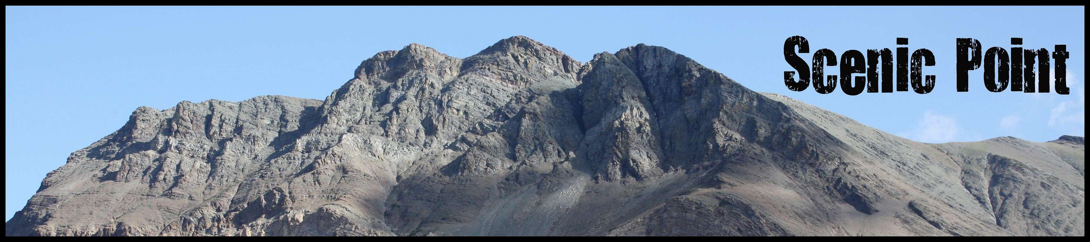
Scenic Point is a dominant land feature on the ridge to the south of Lower Two Medicine Lake and can easily be seen for many miles. There is a trail that leads all the way to the top of the Scenic Point and each day during the summer numerous people hike to this high point along a trail leading from the Two Medicine Valley to East Glacier, Montana.
Many who know where Scenic Point is would argue that it is not a peak at all.
They would postulate that Scenic Point does not deserve mention on the same web site that feature peaks like Whitney, McKinley, Everest or even Glacier National Park’s 10,000 foot peaks such as Mount Jackson or Mount Stimson.
Many others would beg to differ.
 Scenic Point
They would respond that height or notoriety does not matter. What matters it is the significance of the view and the overall experience that is involved in achieving a worthy goal of standing on a high point anywhere.
Let’s take some time and examine the following definitions to see if they help in answering this question.
The On-line dictionary, Dictionary.com, provides a definition of a peak as:
the highest or most important point or level
Scenic Point seems to be the most important level along this ridge; it can be seen for miles and is easily distinguished from other “points” along this ridge.
It also provides the definition of a mountain as:
a natural elevation of the earth's surface rising more or less abruptly to a summit, and attaining an altitude greater than that of a hill, usually greater than 2000 ft. (610 m).
Topographic Observation: Scenic Point stands at 7,522 feet in elevation. Lower Two Medicine Lake at full pool has a surface elevation of 4,882 feet in elevation. This 2,640 feet difference certainly qualifies Scenic Point to be a “mountain” according to the above definition.
 Following the Leader
 A "Family Friendly" Scramble
Perhaps the above definitions strongly support Scenic Point to be considered a mountain but consider the following as well.
J. Gordon Edwards, the godfather of climbing in Glacier National Park, further supports this notion as he included Scenic Point in the same sentence as other mountains in the Two Medicine Valley. He wrote, “Popular climbs nearby include: Scenic Point (7,522); Appistoki Peak (8,164); Mount Henry (8,847); Mt. Ellsworth (8,581); Never Laughs Mountain (7,641); Grizzly Mountain (9,067) and Painted Teepee (7,650).
Edwards also wrote that, “As Rolf Larson observes, ‘Along the Scenic Point trail there are several beautiful points from which to enjoy the Two Medicine drainage. The trail takes you through a couple of beautiful, age-snarled stands of several-hundred-year-old limber pines. From Scenic Point, on a clear day, the Sweet Grass Hills stand out over the eastern horizon.’”
Perhaps the biggest drawing card for Scenic Point is that this is a peak that is
“Family Friendly.”
Scenic Point is a great option for a “Family Climb” in the Two Medicine area. Total trip distance is 3.1 miles (5.0 km) and has an elevation gain of approximately 2,240 feet.
There are no other peaks in this portion of the park that are as easily attainable. Peaks like Oberlin and Haystack Butte in the Logan Pass area are also easily climbed by most families with school-aged children or younger if the parents are willing to carry them on their back!
Getting There:
 Two Medicine Valley
Get here anyway you can!
To visit Glacier National Park is to enter a place where Heaven touches the earth affording brief glimpses into the wonders of Creation.
Glacier National Park, the Crown of the Continent, is located in northwestern Montana and shares a border with Waterton International Peace Park in Canada. The Scenic Point Ridge Walk is located in the Two Medicine Valley in the southeastern corner on Glacier National Park.
Driving Instructions from East Glacier, Montana :
After reaching East Glacier, Montana on Highway 2 and travel 4 miles (6.44 km) North on State Highway 49 to the Two Medicine turnoff. Drive to the end of the road and park in the Two Medicine Parking lot.
Driving Instructions from St. Mary’s, Montana :
Travel south on Highway 89 to Kiowa Junction, turn right on to Highway 49 and continue 9 to the Two Medicine turnoff. Drive to the end of the road and park in the Two Medicine Parking lot.
Go to Plan Your Visit road conditions, road repairs and delay schedules as well as estimated opening information.
Two Medicine Trail Map
Glacier Map
Red Tape:
 Blue Bells
Vehicle single entry fee for Glacier National Park is $25.00 for 7 Days, $12.00 per person for single hiker, motor biker or bicyclist. See Plan Your Visit for other information regarding all of the National Park entrance fee information.
An "America The Beautiful Federal Lands Recreational Pass" for goes for $80.00 which gives entrance to all National Parks, National Forests, BLM, US Fish & Wildlife, and Bureau of Reclamation sites for one year from date of purchase.
If you are planning on visiting Waterton Park make sure you have a passport to simplify crossing the border.
See Rules and Regulations governing Glacier National Park.
CLIMB REGISTRATION: You do not have to register for day climbs in Glacier National Park but it is recommended. Backcountry travel regulations can be found at Backcountry Travel. There is also information from the Park Service on Mountain Climbing in Glacier.
As with all hiking and climbing in Glacier National Park use caution and practice good manners with the wildlife. You are in bear country. Carry bear deterrent spray, don’t hike alone and make some noise. For more information please go to the Park's web site for Bear Information. The U.S. Forest Service also has helpful information on Grizzly Bear Management.
Route Overview:
 Limber Pine
 The Scenic Point Trail
 Approaching the junction
 Mount Henry/Appistoki Peak
 The Plains
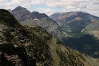 Looking towards Pitamakan Pass
 Lower Two Medicine Lake
GUIDEBOOK: A Climber’s Guide to Glacier National Park; J. Gordon Edwards
Volume Two of Climb Glacier National Park has more details on Scenic Point and suggested routes. It can be ordered at Climb Glacier National Park.
Scenic Point is mentioned in Edwards’ “Routes Among The Peaks” on pages 315-316. This trail is often used as part of the Scenic Point Ridge Walk that includes summiting Medicine Peak, Mount Henry and Appistoki Peak.
It could also be used for reaching Mount Ellsworth and even Never Laughs Mountain.
Special Considerations: The rock in Glacier Park is widely varied and it is not unusual to find several different types of rock on any given route. Know your rocks and be certain of your safety. J. Gordon Edwards has an excellent section in his guidebook on rock and climbing safety. Be safe and know your limitations as well as those who are climbing with you. Also refer to the following links for further details: GNP Rock and Grading System and the GMS Climbing Guidelines.
Route Description:
The trail initially winds along through the open pine slopes along Appistoki Creek. It is generally flat for the first quarter mile which gives the muscles a chance to warm up before the uphill portion begins.
Eventually a series of switchbacks will be used to reach the crest of the ridge far above the Appistoki Creek Valley as well as the Two Medicine Valley which as Rolf Larson said. There are numerous places to stop for photos but stopping at the age-old pine trees definitely will provide some memorable shots of the family or friends along on the trip.
The first 2.25 miles are generally uphill and will challenge the lungs and legs of those who are not in shape. The last time we hiked this trail high school cross country athletes from a running camp ran up this trail. If they can run it you can hike it! Take your time and enjoy the scenery.
The last section of the trail is much flatter and soon Scenic Point comes into view.
Stay on the trail and eventually a fork will be reached. Turn left instead of heading downhill at the sign and head up the slightly less defined trail to the “summit” of Scenic Point.
Return Options:
Retrace your route to the Scenic Point Parking lot.
For those who are interested in continuing along this trail to East Glacier a Blackfeet Reservation permit is required to cross tribal land which begins at the park border. Respect the Blackfeet Tribal Boundary and do not cross the border unless you have a permit ahead of time.
When to Climb and Weather:
 June 2009 Trail Conditions
It is possible to climb to Scenic Point when the road to the Two Medicine Valley opens which is usually in mid to late May or the first few weeks of June depending upon snow fall and spring weather. Obviously the earlier the route is climbed the more snow there will be on the trail and the greater danger for sliding off the trail into a dangerous situation. Generally the trail will be mostly snow free but the middle of June as it was in 2009.
If choosing to hike early in the season be prepared for dealing with snow with either an ice axe or trekking poles. There are some potentially dangerous areas along this trail that could end in serious injury or death if a person were to slide off the trail.
Be ready for late spring winds and constantly changing weather patterns. By mid July and later the weather patterns tend to stabilize and there are not any more glorious days than those spent in Glacier National Park.
Camping and Essential Gear:
 Parting Shot, echoguy photo
There is a park campground at Two Medicine
Other options for camping include: GNP Campground Information, USFS Campgrounds, Camping on the Blackfeet Reservation or East Glacier Campgrounds
A Glacier National Park Topo map would aide in identifying peaks if you are unfamiliar with the area.
There are numerous small seeps along the route until the far western switchback. But bring water anyway.
Hiking poles will aide in your ascent and descent while working through Glacier’s wonderful scree!
If an early season climb is made an ice axe and crampons may be needed to cross snowfields.
Links:
Glacier National Park in PicturesGlacier Mountaineering Society
Two Medicine Trails
Visit Montana