No Respect
Sundial is one of those peaks that just doesn’t get the respect it deserves. Whether this is due to the great views already available at Lake Blanche below, the bushwhacking required to access its southwestern slopes, or its lack of prominence (rises less than 200 feet above the saddle connecting it to the higher Cottonwood Ridge), I really can’t understand why more people wouldn’t want to climb this peak. After all, it is the emblem of the Wasatch Mountain Club, and its jagged dual summits are among the most photographed peaks in the Wasatch.
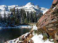
![Monte Cristo & Sundial come into view]() Lake Blanche area on Sep. 23, 2006.
Lake Blanche area on Sep. 23, 2006.![Cottonwood Ridge peaks]() Cottonwood Ridge
Cottonwood Ridge![Dromedary Peak above Lake Blanche]() Dromedary Peak
Dromedary Peak
Until just recently I was just as guilty of neglecting this peak though, and it wasn’t until scrambling along the summit ridge I really understood what I’d been missing. Five years earlier, I had made a half-hearted attempt at the summit, but due to some icy terrain and the fact that I was hiking alone after spotting some cougar tracks in the snow I decided to turn around before any of the fun scrambling. Since then I got sidetracked with other peaks, and it wasn’t until
David recommended it that I even considered trying it again. These are some pictures from my first adventure in the snow:
Beyond Lake Blanche
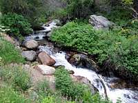
![Mill B South Fork stream]() Mill B South Fork stream
Mill B South Fork stream![Mill B South Fork aspens]() Aspen trees
Aspen trees
We decided to meet at the S-curve trailhead at 7am, and even though I was the first car that had to park out along the road because of the parking lot being full, we really didn’t see many people on the way up. The few people we did run into were lugging big packs, and must have camped up around Lake Blanche the previous night. The overcast skies were a welcome change from my other recent dry and hot Wasatch hikes, and the humidity from the nearby Mill B South Fork stream made it feel like I was actually hiking somewhere tropical.
![First glimpse of Sundial Peak]() Sundial's first appearance
Sundial's first appearance![Dromedary from Lake Blanche Trail]() Dromedary Peak & wildflowers
Dromedary Peak & wildflowers
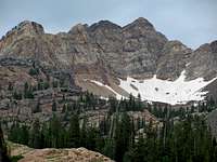
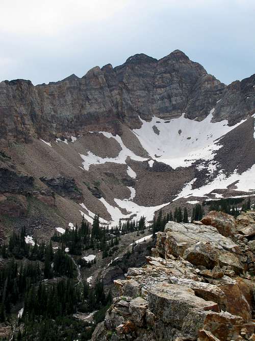
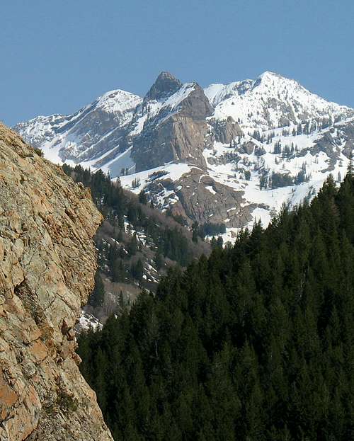
This year’s snowpack was incredible, but almost three straight weeks of 90-degree temperatures down in Salt Lake Valley had put quite a dent in it. After a mile or so, we spotted part of the Cottonwood Ridge, and despite still having large patches of snow, there were enough dry spots to convince us that we’d have snow-free hiking and climbing the entire way to the top of Sundial. After our 20-mile walk along the almost-too-gradual Skyline Trail two weeks ago, this trail definitely seemed steeper, but not enough that it required us to take any breaks. We passed through some large patches of bright yellow wildflowers on our way up the trail, and in one of the clearings we got our first glimpse of Sundial in the distance.
![Lake Blanche on the way up]() Lake Blanche on the way up to Sundial Peak ...
Lake Blanche on the way up to Sundial Peak ...![Lake Blanche on the way down]() ... and again on the way down.
... and again on the way down.![Sundial just before Lake Blanche]() Sundial from near Lake Blanche
Sundial from near Lake Blanche![Monte Cristo from Lake Blanche]() Monte Cristo from Lake Blanche
Monte Cristo from Lake Blanche
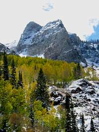
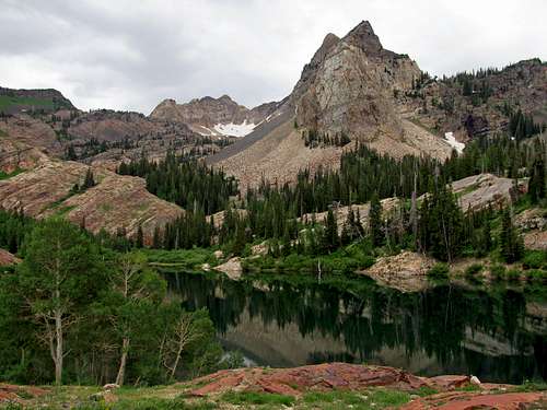
As we got closer to Lake Blanche, we could now see Dromedary Peak, Sunrise Peak, and Jepsen’s Folly (officially un-named peak west of Sunrise that was climbed by a guy who thought he had made it to the top of Sunrise in a white-out). More orange-reddish rock started appearing around us, and the last stretch of trail leading to the lake was like an orange half-pipe. Soon we were at Lake Blanche, and the scenery was fantastic. Besides the amazing view to the southeast of Sundial and Monte Cristo off in the distance, the bright green grass, red quartzite rocks, and yellow and blue wildflowers made for quite the setting. Despite the steepness of the trail, I made a mental note that I simply had to bring Liz and Matthew here sometime. Liz took a few geology classes in college and was always able to tell me how certain rocks formed on our hikes, so I’m sure she would have appreciated the interesting rock colors and formations around the lake.
![Hills east of Lake Blanche]() Green hills over Lake Blanche to the east.
Green hills over Lake Blanche to the east.![Ridge west of Lake Blanche]() Ridge over Lake Florence to the west.
Ridge over Lake Florence to the west.![Brandon at Lake Blanche]() Brandon at Lake Blanche
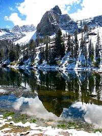
Brandon at Lake Blanche![Sundial reflection]() Sundial Peak reflection
Sundial Peak reflection
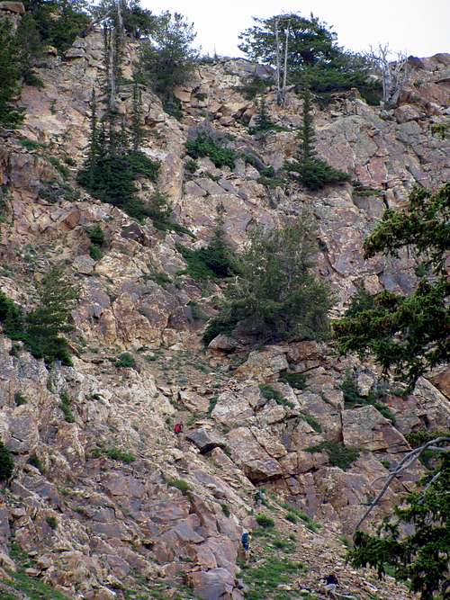
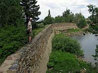
We crossed the man-made wall separating Lake Blanche from Lake Florence, and shortly after this the trail ended. The first time around, there were a couple feet of snow, and the easiest way was to actually stay close to the small run-off stream coming down from Sundial’s southwest slopes. We tried the same approach this time, but soon found that with all the fallen trees and dense bushes it was easier actually looping around further to the west (away from Sundial), staying on the large rock slabs up above the surrounding vegetation. Eventually we came to a large slab slope with a few cairns, helping us know we were on the right path.
At this point it started raining slightly, so David and I remarked that if it started coming down heavier then we might have to turn back since the big rock slabs would be much more slippery then. We followed the run-off up the smooth rock slope until we spotted the weakness in the stone walls surrounding the western side of Sundial, and then proceeded to hike up a faint trail through a small talus field. We reached a small headwall at this point that was easier to bypass by backtracking to the north briefly, and after climbing up around another small run-off stream we found ourselves on a more gradual slope leading to the southeast towards the saddle separating Sundial from Cottonwood Ridge to the south.
![Sundial Peak mini falls]() Our path up the run-off along Sundial's west slope.
Our path up the run-off along Sundial's west slope.![Sundial Peak southwest slope]() Southwest slopes
Southwest slopes![Sundial Peak snowfield]() Snowfield
Snowfield
Fortunately the drizzle eventually went away (even though temperature-wise I loved it), and the skies looked to be clearing up as we made our way towards the saddle. We followed the stream for the most part, crossing some more large black slabs and loose talus on the way. With our eyes we followed what appeared to be the main summit of Sundial to the south, and it looked like we could start making our way up to the ridge before going all the way to the low point of the saddle. At this spot there were more trees growing out of the step rock walls, and it looked like it would be doable and save us from having to continue southeast along the stream. We made our way up the steep slope, and despite the loose scree on the various ledges on our way up, there was enough solid rock along the way for us to pull ourselves up.
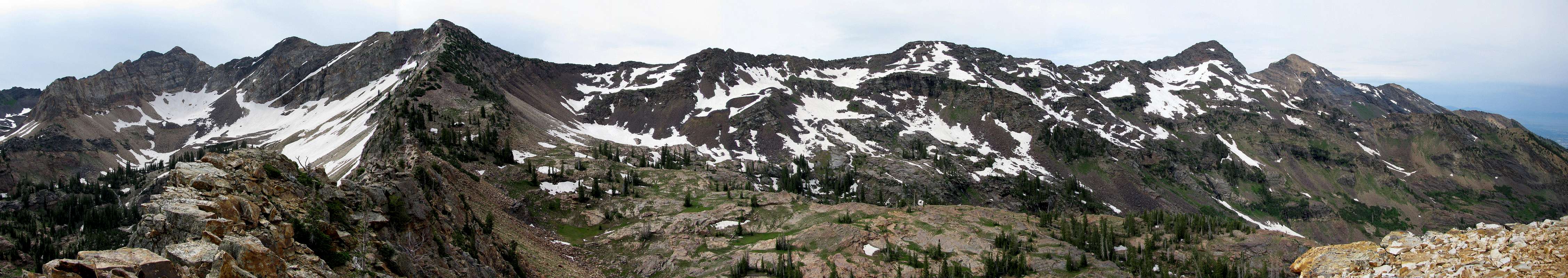
![]()
Cottonwood Ridge panorama
The Best Part
![Sundial summit ridge]() Looking towards the top ...
Looking towards the top ...![Sundial ridge]() ... and bottom of the scramble on Sundial Peak's south ridge.
... and bottom of the scramble on Sundial Peak's south ridge.![Sundial summit behind Brandon]() False summit
False summit![Sundial scramble views]() Scrambling views
Scrambling views
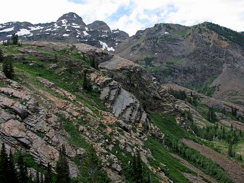
Upon reaching the ridge after a couple hundred vertical feet of scrambling, we were greeted with an awesome view of Monte Cristo and its neighboring un-named peaks on the Cottonwood Ridge. There was an abrupt drop-off of the ridge we were on to the east, and to the north we could now see the exposed semi-knife-edge ridge leading to the summit of Sundial. The scrambling here was a blast, and definitely ranks as one of my favorite routes in the Wasatch (although the Devil’s Castle traverse may trump it when I get around to trying that one). It was somewhat similar to the ridge scrambles I’d seen on Pfeifferhorn and Lone Peak, with just as much exposure as either of those, but technically not any harder. Here are some pictures of David taking part in the scrambly goodness:
![Sundial Peak crux]() Coming up the crux Coming up the crux |
|
|
![Sundial false summit]() On top false summit
On top false summit![View east from Sundial crux]() View east from crux
View east from crux
We stayed right on top of the ridge for the most part, but at one point we came to a large boulder in front of us which seemed to be the crux. I investigated off to the right (east) side, and despite having to make our way over some smaller loose-looking boulders (which I made sure to stomp on while holding the more solid looking wall on the left before committing my full weight to them), after dropping down on that side and making our way back up, we could now make out the actual summit just a few dozen feet ahead of us.
![Sundial summit over Lake Blanche Basin]() Sundial Peak over Lake Blanche basin.
Sundial Peak over Lake Blanche basin.![Monte Cristo from Sundial]() Monte Cristo from Sundial Peak summit.
Monte Cristo from Sundial Peak summit.![Kessler Peak from Sundial Peak]() Kessler Peak
Kessler Peak![Brandon at Sundial summit]() Brandon at the summit
Brandon at the summit
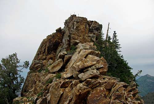
We signed the summit register (in a large gray mailbox covered by some rocks) and busted out the snacks, admiring the awesome scenery. Walking a bit further north along the summit ridge we were able to look down on the lower summit of Sundial, which is the only one visible when viewing the peak from across Lake Blanche to the northwest.
![Sundial summit pic]() David and Brandon on the summit.
David and Brandon on the summit.![Sundial lower summit]() Looking down at the lower summit of Sundial Peak.
Looking down at the lower summit of Sundial Peak.![Dromedary & East Twin]() Dromedary & East Twin to the west
Dromedary & East Twin to the west![Basin east of Sundial Peak]() Basin to the east
Basin to the east
We had contemplated going up to the un-named peak immediately above the ridge connecting Sundial to Cottonwood Ridge from here, but today I was feeling a bit lazy so we decided to call it good at this point. I told David that some people actually traverse the entire ridge in one day, and from this angle that feat seemed even more impressive. Until I get back in better shape, usually just getting up somewhere on the Cottonwood Ridge itself seems like a big enough accomplishment for me. After some summit photos we made our way down.
![Scramble to Sundial ridge]() Scrambling back down from the ridge.
Scrambling back down from the ridge.![Pond northwest of Sundial]() Scenic pond
Scenic pond![Sundial Peak]() Sundial climbing walls
Sundial climbing walls
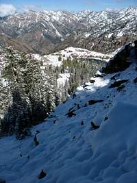
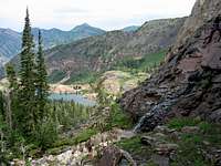
The same steep slope west of the ridge was a bit more difficult on the way down because of all of the loose scree, so I had to be more careful this time to not knock any rocks onto David below me. Some scree-skiing would have been nice (like what you can do descending to the upper Broads Fork meadow from the Sunrise-Twins saddle), but since this part was steeper it wasn’t safe enough to try that. At the bottom we ran into the first people we’d seen since Lake Blanche. They asked if we made it to the top, and upon responding affirmatively, they decided to take the quicker option of the same slope as us instead of continuing to the low point of the saddle, to save distance not doubling back as far. We continued on down the same way we came up, with good views of Lake Lillian, Lake Florence, and Lake Blanche below us to the north.
![Wildcat Ridge over lakes]() Lake Lillian, Lake Florence, and Lake Blanche below us to the north.
Lake Lillian, Lake Florence, and Lake Blanche below us to the north.![Lake Blanche wall]() Lake Blanche wall
Lake Blanche wall![Orange halfpipe]() Orange halfpipe
Orange halfpipe
At the lake we finally encountered all of the people I had expected to see earlier on a Saturday morning. Among them were a few younger children, as well as several people who I was surprised had actually made it up to the lake. Good for them. On the way down we probably saw over a hundred people making their way up to the lake. With the dense vegetation it was a bit difficult to maintain two lanes of traffic, so usually we or the people coming up would step off into the bushes on the side. It makes me think that this trail would be a pain to maintain, and gives me a greater appreciation for those who do trail maintenance work here. About a mile from the bottom we came upon a slower-moving mother and son who wouldn’t let us pass, so it took us a bit longer to get back to the parking lot.
![Dromedary & Sunrise]() Cottonwood Ridge from the Lake Blanche Trail.
Cottonwood Ridge from the Lake Blanche Trail.![Lake Blanche trail]() Wildflowers seen going back down the Lake Blanche Trail.
Wildflowers seen going back down the Lake Blanche Trail.![Cottonwood Ridge run-off]() Cottonwood Ridge run-off
Cottonwood Ridge run-off![Run-off near Lake Blanche Trailhead]() Trailhead run-off
Trailhead run-off
As long as you do the hike early enough or on a weekday then the crowds aren’t too bad, and I’d highly recommend going past Lake Blanche up to Sundial. The views are even better higher up, and the scramble along the summit ridge is among the most fun ones I’ve done in the Wasatch. Another advantage is that you can tag the summit and be back down in just half a day (with good route-finding skills past the lakes), making it much less strenuous than the peaks above Broads Fork, for example. I’d definitely classify it as a must-do hike for any Wasatch peak-bagger.
Sundial Peak Stats
DISTANCE:
9 miles roundtrip
MILL B SOUTH FORK TRAILHEAD:
6,200 feet
SUMMIT ELEVATION:
10,320 feet
ELEVATION GAIN:
4,150 feet
DIFFICULTY:
Class 3
TIME:
6 hours
![Sundial Peak from Mill B North Trail]() Sundial Peak from the Mill B North Trail.
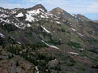
Sundial Peak from the Mill B North Trail.![Our route up Sundial Peak]() Our route to the top, seen from Mount Olympus.
Our route to the top, seen from Mount Olympus.


Comments
Post a Comment