
|
|
Canyon |
|---|---|
|
|
37.21110°N / 112.8966°W |
|
|
Hiking |
|
|
Overview
 Pot holes and slickrock decorate the east side of Zion and this route is not exception. The scenery is spectacular from beginning to end.
Separation Canyon
Distance: 2.5 Miles round trip.
Elevation: 5950 Feet
On a December day Tim Tabor, Tanya, and myself decided to explore some less snow covered areas on the east side of Zion National Park. Originally our plans were to take us up some steep slickrock to a pass that I deemed very difficult because of the light dusting of snow that we had received the two previous days. Instead, South Ariel Peak was our first objective because the southern slopes were free of snow. We enjoyed the hike and rewards offered by this relatively easy summit to climb, but looking southeasterly we could see a wash/canyon that we had yet to explore. Since the day was early we decided to fill the rest of the afternoon with a new adventure.
The wide open wash that had caught our interest headed south from Route 9. After an uneventful descent from South Ariel Peak we drove about 1 km east on Route 9 from the mouth of Keyhole Canyon which is also the parking area for South Ariel Peak. There is a good sized pullout on the south side of the road which will fit three vehicles. We loaded our necessary gear and headed off to do some exploring.
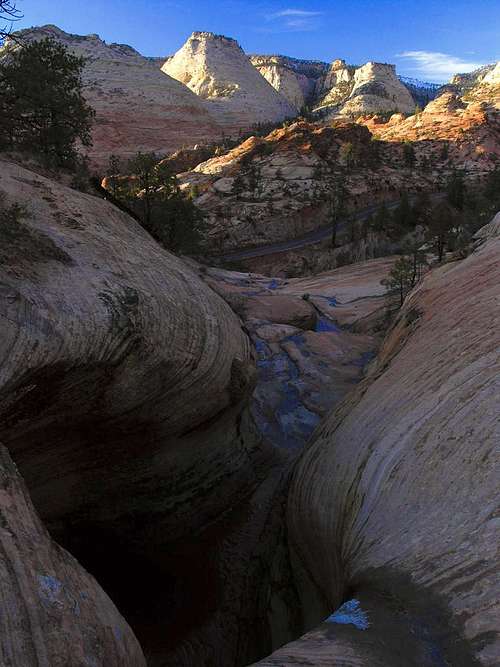
This easy hike meanders south from Route 9 on the eastern side of Zion National Park toward Parunuweap. A great hike to do in the winter months while temperatures are mild and days are short. Along the way, desert tanks may contain some water adding to the charm particularly if they are frozen. Predominately this is a wide open wash that gently climbs to the saddle separating the spectacular white domes of the east side of Zion near Route 9, from the infrequently traveled plateaus above Parunuweap. Just above the saddle is a wonderful little cap-rock summit that is fairly easy to climb sporting views to the south and north. A great place to sit back, have some lunch and relax.
We did this hike after spotting it from on top of South Ariel Peak. After descending the peak, we began hiking “Separation Canyon” at about noon and finished the entire walk from car to car in less than 4 hours.
Separation Canyon

Although water is rare on the east side of the park select pot holes here and there capture rainfall and store it until it finally evaporates.
Separation Canyon
Drive 14.9 miles west of Mt. Carmel Jct., or 1.9 miles west of the east entrance of Zion National Park to get to the parking area. From the east end of the Zion-Mt. Carmel Tunnel drive east 3.6 miles for the parking area.
The hike took us immediately down a steep embankment into Clear Creek. From the bottom of Clear Creek we headed downstream about 300 metres until a tree covered slope showed enough weakness on the left side that we could ascend toward a saddle in the ridge. We scrambled up a slickrock ramp, but on the return realized that a very easy to follow animal path bypassed the steeper slickrock. This allowed us to enter into the large wash dubbed “Separation Canyon”. Once in the wide open wash, we made a quick jaunt downstream to view the charming slickrock "Falls" that emptied into Clear Creek. We then turned south and headed up-canyon.
Upstream travel was unimpeded, however the stream bed split shorty. I explored to the left and then decided the right stream bed might be the best way to go. After about 100 metres I decided to ascend south out of the stream-bed to gain a ridge. This was the wrong choice. In retrospect, it is better to bear left at the stream-bed intersections. The objective for us, at least that late afternoon was to arrive at a nipple we called "Separation Point" that was visible from the wash below.
Either direction will put you on a ridge that will make the final ascent possible, but the wash to the left avoids a lot of bushwhacking.
Parking our vehicles .7 of a mile east of the parking area for Keyhole Slot Canyon, we then dropped down into Clear Creek, and then walked a few hundred meters downstream.
Separation Peak
 364263:alignright:medium
Winter is an ideal time to photograph the mountain on the east side of the park when pot holes of water allow reflection.
Like most of the unnamed canyons and peaks on the east side of Zion National Park, there is no red tape other than dishing out the park entrance fee to get inside of the park.
Entrance Fees
America the Beautiful Pass and Fees
This is a great pass to get if you are visiting a lot of National Park and Monuments since it lets you into just about everything.
$80 (annual) Pass to "all" public lands
(Private Vehicle $25 (7 days)
Zion Park Pass $50 (annual)
Pedestrian/Bike $12 (7days)
Over-sized Vehicle Fee (2 times /7days)
Backcountry Permit: $10
Over-sized Vehicles
If you are bringing a camper or bigger into the park you need to know that there is a $15 (good for 2 trips in 7 days) escort fee for anything 7'10" wide and/or 11'4" tall or larger.
Camping
 The larger and center peak in this photo is Separation Peak. This view is from the other side of the highway along the Jug Handle Arch Route.
The Watchman Campground is near the south entrance of the park and is open year-round. Sites are given on a first come, first use basis November through March. Reservations can be made during the rest of the year. $16 per site without electric hookups, $18 per site with electric hookups, and $20 per site for river sites. Reservations: 877-444-6777
The South Campground is also located near the south entrance and is open March through October. All sites in the South Campground are first-come, first serve. $16 per site, per night.
Both of these campgrounds provide restrooms, picnic tables, RV dump, drinking water and utility sinks. There are no showers.
Free Camping near Zion
Mosquito Cove, located between mile markers 23 and 24 on the south side of Highway 9, south of Springdale. Also you can probably camp on the BLM land around Eagle Crags.
Showers
Zion-area showers:
Tsunami Java & Juice - Springdale
Zion Rock & Mountain Guides -Springdale
Zion Food and Lodging
Food and Lodging - NPS Site
Informative Links about Zion National Park
National Park Service
Springdale Chamber Commerce
East Zion Tourism Council